Safety Bay, Western Australia facts for kids
Quick facts for kids Safety BayPerth, Western Australia |
|||||||||||||||
|---|---|---|---|---|---|---|---|---|---|---|---|---|---|---|---|

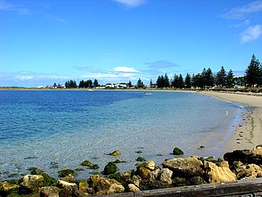
Safety Bay seen from the south
|
|||||||||||||||
| Postcode(s) | 6169 | ||||||||||||||
| Area | 4.6 km2 (1.8 sq mi) | ||||||||||||||
| LGA(s) | City of Rockingham | ||||||||||||||
| State electorate(s) | Rockingham | ||||||||||||||
| Federal Division(s) | Brand | ||||||||||||||
|
|||||||||||||||
Safety Bay is a coastal suburb located south of Perth, the capital city of Western Australia. It is part of the City of Rockingham.
Contents
Exploring Safety Bay's Past
Safety Bay was once a small, sheltered area on the north side of Warnbro Sound. In 1837, a surveyor named John Septimus Roe explored the area. He called it "Safety Bay" because it was a safe place for boats to anchor.
Early Plans for a Port
In the 1830s, a man named Thomas Peel thought Safety Bay would be a great spot for a port. He wanted to start a whaling business there. He also planned to export jarrah timber from the inland forests.
Governor Stirling and Surveyor-General Roe approved Peel's idea. In 1842, a town site called 'Liverpool' was even planned. However, Peel's port project did not happen at that time.
The Disappearing Harbour
Roe had measured the water depth in the area, finding it to be about 12.8 meters. This deep area was later called "Peel Harbour." But by 1846, the harbour had filled with sand and mud. It was no longer deep enough for ships. People started calling it "Peel Basin" instead.
Over time, this basin completely disappeared from maps by 1890. Some people think the harbour might be slowly reforming today. For example, Tern Island reconnected to the Safety Bay shore in 2001.
Growth and Development
In the late 1920s, the land in Safety Bay was divided into smaller lots for building. The suburb then grew steadily through the 1930s. Safety Bay Road, which connects Safety Bay to Rockingham, was improved during World War II. It was later extended to connect with major highways like the Kwinana Freeway and the Forrest Highway.
Fun Things to Do in Safety Bay
Safety Bay is famous for its calm, safe, and sheltered beach. This made it a popular spot for family holidays many years ago. The beach offers amazing views of Warnbro Sound.
Water Activities and Wildlife
The boat ramp at Safety Bay Beach is very popular for launching boats. Many people enjoy fishing and sailing here. Nearby, Shoalwater beach is a favorite spot for windsurfers and kitesurfers.
The entire bay is part of the Shoalwater Islands Marine Park. This park is a special home for many birds and marine animals. You can find penguins, dolphins, whales, and sea lions here. Local boat tours offer chances to see this amazing wildlife up close.
Local Amenities
Safety Bay has many shops, cafes, and restaurants for visitors and residents. It is also close to larger shopping areas and businesses in Rockingham.
Getting Around Safety Bay
Safety Bay has a good road system. The nearby Kwinana Freeway makes it easy to drive to Perth, which is about 50 kilometers away. The drive usually takes about 45 minutes.
You can reach the port city of Fremantle in about 30 minutes by car. The resort city of Mandurah is only 20 minutes to the south. Buses also connect Safety Bay to these places. These buses link up with the Perth-Rockingham-Mandurah train service. A train ride from Rockingham to Perth takes about 33 minutes.
There's also a bike path, Perth Bicycle Network route SW38. It connects Waikiki Beach in Safety Bay with Rockingham Beach in Rockingham.
 | Jessica Watkins |
 | Robert Henry Lawrence Jr. |
 | Mae Jemison |
 | Sian Proctor |
 | Guion Bluford |

