Sagamore Hills Township, Summit County, Ohio facts for kids
Quick facts for kids
Sagamore Hills Township
|
|
|---|---|

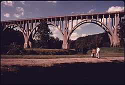
The Brecksville-Northfield High Level Bridge
|
|

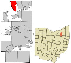
Location in Summit County and the state of Ohio.
|
|
| Country | United States |
| State | Ohio |
| County | Summit |
| Area | |
| • Total | 11.3 sq mi (29.3 km2) |
| • Land | 11.3 sq mi (29.2 km2) |
| • Water | 0.0 sq mi (0.0 km2) |
| Elevation | 932 ft (284 m) |
| Population
(2020)
|
|
| • Total | 10,845 |
| • Density | 959.7/sq mi (371.4/km2) |
| Time zone | UTC-5 (Eastern (EST)) |
| • Summer (DST) | UTC-4 (EDT) |
| ZIP code |
44067
|
| Area code(s) | 330 |
| FIPS code | 39-69428 |
| GNIS feature ID | 1087015 |
| Website | Sagamore Hills Township |
Sagamore Hills Township is a community located in Summit County, Ohio, in the United States. It is one of nine townships in Summit County. In 2020, about 10,845 people lived there.
Contents
Where is Sagamore Hills Located?
Sagamore Hills Township is in the northwestern part of Summit County. It shares borders with several other towns and townships.
- To the north, it borders Walton Hills.
- Northfield is to the northeast.
- To the east, you'll find Northfield Center Township.
- Boston Township is located to the south.
- To the west, it borders Brecksville.
- The northwest corner touches Independence.
- Valley View is also to the northwest, just east of Independence.
No larger cities or towns are located directly inside Sagamore Hills Township.
What is the History of Sagamore Hills?
Sagamore Hills is the only township with this name in the entire state of Ohio. Its unique name helps it stand out.
Schools in Sagamore Hills
Students in Sagamore Hills Township attend schools that are part of the Nordonia Hills school system. One of the elementary schools, Rushwood Elementary, is located right in Sagamore Hills.
See also
 In Spanish: Municipio de Sagamore Hills para niños

All content from Kiddle encyclopedia articles (including the article images and facts) can be freely used under Attribution-ShareAlike license, unless stated otherwise. Cite this article:
Sagamore Hills Township, Summit County, Ohio Facts for Kids. Kiddle Encyclopedia.
