Saint-Bois facts for kids
Quick facts for kids
Saint-Bois
|
|
|---|---|
|
Part of Arboys en Bugey
|
|

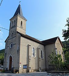
Église St Baudille
|
|
| Country | France |
| Region | Auvergne-Rhône-Alpes |
| Department | Ain |
| Arrondissement | Belley |
| Canton | Belley |
| Commune | Arboys en Bugey |
| Area
1
|
9.22 km2 (3.56 sq mi) |
| Population
(2021)
|
142 |
| • Density | 15.40/km2 (39.89/sq mi) |
| Time zone | UTC+01:00 (CET) |
| • Summer (DST) | UTC+02:00 (CEST) |
| Postal code |
01300
|
| Elevation | 301–778 m (988–2,552 ft) (avg. 320 m or 1,050 ft) |
| 1 French Land Register data, which excludes lakes, ponds, glaciers > 1 km2 (0.386 sq mi or 247 acres) and river estuaries. | |
Saint-Bois (pronounced "san bwa") was once a small town or village in eastern France. It was located in the Ain department.
On January 1, 2016, Saint-Bois joined with another town. It became part of a new, larger town called Arboys en Bugey. This means Saint-Bois is no longer a separate commune.
Population in Saint-Bois
The number of people living in Saint-Bois changed over time. Counting the population helps us understand how towns grow or shrink. Here's how many people lived there in different years:
| Historical population | ||
|---|---|---|
| Year | Pop. | ±% p.a. |
| 2006 | 116 | — |
| 2011 | 127 | +1.83% |
| 2021 | 142 | +1.12% |
| Source: INSEE | ||
As you can see, the population of Saint-Bois slowly grew. In 2006, there were 116 people. By 2021, just before it merged, the population had reached 142 people.
See also
 In Spanish: Saint-Bois para niños
Black History Month on Kiddle
Famous African-American Scientists:
 | Charles R. Drew |
 | Benjamin Banneker |
 | Jane C. Wright |
 | Roger Arliner Young |

All content from Kiddle encyclopedia articles (including the article images and facts) can be freely used under Attribution-ShareAlike license, unless stated otherwise. Cite this article:
Saint-Bois Facts for Kids. Kiddle Encyclopedia.


