Saint-Joseph Lake facts for kids
Quick facts for kids Saint-Joseph Lake |
|
|---|---|
 |
|
| Location | Lac-Saint-Joseph (TNO), La Jacques-Cartier Regional County Municipality, Capitale-Nationale, Quebec |
| Coordinates | 46°54′50″N 71°38′39″W / 46.91389°N 71.64417°W |
| Lake type | Lake of dam |
| Primary inflows | Rivière aux Pins, ruisseau Le François |
| Primary outflows | Ontaritzi River |
| Basin countries | Canada |
| Max. length | 8.1 km (5.0 mi) |
| Max. width | 2.33 km (1.45 mi) |
| Surface area | 11.31 ha (0.0437 sq mi) |
| Max. depth | 37 m (121 ft) |
| Surface elevation | 159 m (522 ft) |
| Islands | 1 |
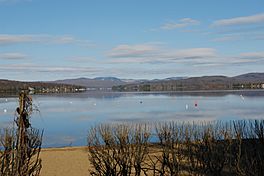
Saint-Joseph Lake (French: Lac Saint-Joseph) is a beautiful freshwater lake in Quebec, Canada. It's located in the La Jacques-Cartier Regional County Municipality, within the Capitale-Nationale area.
This lake is a popular spot for fun activities and vacations. Many people come here to relax and enjoy the outdoors. The area is known for its forests, mountains, and easy access to the city of Quebec. The Duchesnay tourist resort covers most of the lake's shores, offering lots of things to do.
Forestry, which is about managing forests, is another important activity here. A road called Chemin Thomas-Maher goes all around the lake. It's used by both tourists and for forestry work.
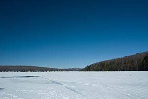
During winter, the lake usually freezes over. It's often safe to walk or play on the ice from late December to early March.
Contents
Exploring Saint-Joseph Lake
Saint-Joseph Lake is about 8.1 kilometers (5 miles) long, stretching from north to south. It covers an area of 11.31 square kilometers (4.37 square miles). The distance around the lake is 22.4 kilometers (13.9 miles).
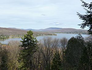
This lake was formed by glaciers a very long time ago. It's located about 30 kilometers (18.6 miles) west-northwest of Quebec. The lake has a unique shape, narrowing in the middle, almost like a peanut. The northern part of the lake is larger than the southern part.
Water Sources for the Lake
Saint-Joseph Lake gets its water from several streams and rivers. The main ones are:
- The Rivière aux Pins: This river flows into the east side of the lake. It brings water from many smaller streams and lakes, including Lake Belle Truite, Lakes Tantaré, Cesena, Regio, and Lac des Pins River. Some of these waters come from the Canadian Forces Base Valcartier area.
- Le François stream: This stream flows into the northwest side of the lake. It is fed by three small mountain lakes, including Lac Le François.
The Ontaritzi River's Journey
The water from Saint-Joseph Lake flows out into the Ontaritzi River. This happens at the Duchesnay dam, which holds back the lake's waters. The river is about 4.5 kilometers (2.8 miles) long.
First, the Ontaritzi River flows west for about 600 meters (0.37 miles). Along this path, it goes under two bridges:
- The Jacques-Cartier cycle path bridge, which is part of the "Green Route."
- The Route 367 bridge.
The river also flows past the Duchesnay forestry school. After this, the river turns southeast and flows for another 2.1 kilometers (1.3 miles). It then crosses the Laroche Rapids, heading south. Finally, the Ontaritzi River joins the Jacques-Cartier River. It flows around Île à Prévost, an island located near the village of Sainte-Catherine-de-la-Jacques-Cartier. The entire Ontaritzi River flows within the area of Sainte-Catherine-de-la-Jacques-Cartier.
Who Manages the Lake Area?
Most of Saint-Joseph Lake (the west, north, and east sides) is managed by the town of Lac-Saint-Joseph. The southeast part of the lake is managed by the town of Fossambault-sur-le-Lac, which was founded in 1949. The area near where the water flows out is managed by Sainte-Catherine-de-la-Jacques-Cartier.
There are a few small communities, or hamlets, around the lake:
- Duchesnay: Located southwest, near the dam.
- Lake View: On the southeast side.
- Lac-Saint-Joseph: To the west.
The main road around the lake has different names depending on where you are. It's called "Chemin Thomas-Maher" in Lac-Saint-Joseph, "route Duchesnay" in the Duchesnay hamlet, and "route de Fossambault" in Fossambault-sur-le-Lac.
The Name of the Lake
The name "Lac Saint-Joseph" has a long history! It first appeared on a map made in 1632 by Samuel de Champlain, a famous French explorer.
A French friar named Gabriel Sagard wrote in 1636 about how the lake got its name. He said that the French named it "Sainct Joseph" because a priest named Joseph Le Caron spent part of a winter there with the local Indigenous people. They hunted animals like caribou, which were plentiful.
In 1656, the name "L. St Joseph" was shown on a map by Nicolas Sanson d'Abbeville. Before that, in the early 1800s, the Indigenous people called this lake "Ontarietsi" or "Ontaritzi." In 1833, a newspaper called the Gazette de Québec used the name "Lontarizé."
Around that time, about thirty Irish families moved to the southeast area of the lake, which is now Fossambault-sur-le-Lac. The lake was also sometimes called "Grand Lac des Vents," meaning "Great Lake of Winds." The name "Lac Saint-Joseph" was officially recognized in 1912.
The name "Lac Saint-Joseph" was formally added to Quebec's official list of place names on December 5, 1968.
 | May Edward Chinn |
 | Rebecca Cole |
 | Alexa Canady |
 | Dorothy Lavinia Brown |


