Saint Charles River (Valleyfield) facts for kids
Quick facts for kids Saint Charles River |
|
|---|---|

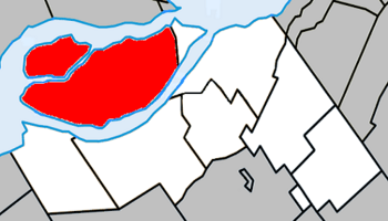
Map of the Rivière Saint-Charles/Salaberry-de-Valleyfield
|
|
| Native name | Rivière Saint-Charles |
| Country | Canada |
| Province | Quebec |
| Physical characteristics | |
| Main source | Lake Saint Francis 250 m (820 ft) 45°15′20″N 74°09′05″W / 45.25556°N 74.15139°W |
| River mouth | Lake Saint-Louis 45°17′36″N 74°02′20″W / 45.29333°N 74.03889°W |
| Length | 25 km (15.5 mi) |
The Saint Charles River (French: Rivière Saint-Charles) is a part of the Saint Lawrence River. It begins in Salaberry-de-Valleyfield, Quebec, Canada. This river separates two islands: Grande-Île and the Island of Salaberry. These islands are about 50 km east of Montreal. The river is 8 km long. It flows from Lake Saint Francis east to Lake Saint-Louis, dropping 24 meters along its path.
Contents
Exploring the Saint Charles River's Location
The Saint Charles River is not a separate river on its own. It is actually an arm, or branch, of the much larger Saint Lawrence River. It starts at the end of Lake Saint Francis in Salaberry-de-Valleyfield. From there, it flows through the town of Saint-Timothée. Finally, it empties into Lake Saint Louis to the east.
Originally, there were two channels at the eastern end of Lake Saint Francis. These were a northern channel and the Saint Charles River. Because of fast-moving water, several canals have been built over time. The Old Beauharnois Canal and the Soulanges Canal are no longer used. However, the Beauharnois Canal has changed how the Saint Charles River flows. In the past, this river was a key source of power for factories in Salaberry-de-Valleyfield.
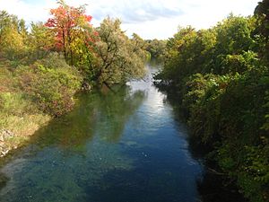
Most of the river's edges have buildings or homes on them. But some parts of its banks are still natural and undeveloped.
How the Landscape Shaped the River
The Saint Charles River is located in an area called the Saint Lawrence Lowlands. The ground here is mostly flat limestone rock. However, the landscape was mainly shaped by ancient glaciers. These glaciers left behind deep, rich soils across the flat land. This area is rarely more than 200 meters above sea level.
Long ago, before many trees were cut down and buildings were put up, the Saint Lawrence Lowlands had many forests and wet areas. Today, only small pieces of these natural areas remain. The region between Lake Saint Francis and Lake Saint Louis used to have a diverse river environment. Now, it has become a slower-moving lake-like area. The Saint Charles River has not been heavily dammed. However, its natural environment has still been greatly changed.
The Saint Lawrence Lowlands is Canada's most developed area. Most of Canada's people and factories are found here. The Saint Charles River area has seen a lot of growth in farming and industry. Many homes are also built along the river, which is common for rivers in this region. Only about 15% of the natural shoreline in this area is left today. The local government of Valleyfield recently bought a part of the river. They have stopped new building projects there for now.
Why Fish Migration Matters Here
Many dams have been built on the Saint Lawrence River. This makes it hard for some fish to move up and down the river. Many fish species can easily swim downstream through the Beauharnois Dam. But some, like eels and lake sturgeon, cannot survive going through the dam's turbines.
The Saint Charles River is important for fish because it has only one small dam near its mouth. This allows fish to move more easily up and downstream. A special path for fish, called a fish ladder, was built to help them migrate. Studies have shown that this fish ladder has helped some species, like minnows, to move more freely.
A Look Back at the Saint Charles River's Past
Before factories were built, the river and its nearby lands were mostly used for farming. Both the Iroquois people and early European settlers farmed here. In the mid-1800s, people realized the river could be used to create electricity. Soon, factories began to appear in the area.
The old Beauharnois Canal was built in 1849. Its power was used by a saw mill called Valleyfield Mills. This mill was once Canada's biggest supplier of paper for newspapers. Because of its power potential, many factories were built along the Saint Charles River and the old Beauharnois Canal over time.
During the time of heavy factory growth, the river's health was often ignored. After the first Beauharnois Canal was built in 1849, a dam was placed at the river's mouth. This was done to control its flow. Until the 1970s, the river's flow was kept very low. This allowed as much water as possible to go through other canals.
However, waste from factories along its banks started to make the river dirty. For example, a factory called Expro Inc., which makes chemical products, was known for releasing waste into the river. After many years of this, an agreement was made. Hydro Quebec and the City of Salaberry-de-Valleyfield decided to increase the river's flow. They set it to 30 cubic meters per second. This helped to dilute the unpleasant smells coming from the river.
Since the 1970s, the water flow in the river has stayed constant at 30 cubic meters per second. But not much has been done to clean the river itself. Several studies have shown that the river's water quality is low. It is much lower than the water quality of the Saint Lawrence River in general. The long-term effects of factories and waste have given the river a bad reputation in the community. Sometimes, people even call it the "rivière des étangs," which means "river of dirty ponds."
Fun Activities on the Saint Charles River
Salaberry-de-Valleyfield is a popular spot for people who love boating. Sailing and motorboating are very popular on Lake Saint Francis. The Saint Charles River also has a world-class whitewater kayak course. This course is located at the very start of the river, where it leaves Saint Francis Bay.
The site was completely rebuilt in 2002 for kayak paddling. It offers 300 meters of paddling challenges, from easy to medium difficulty. This spot is great for racing because the water level is controlled and stays mostly the same. Major events have been held here, including the 2004 Canadian Slalom Championships and the 2009 North American Under-23 Paddling Championships.


