St. Leonard, Maryland facts for kids
Quick facts for kids
St. Leonard, Maryland
|
|
|---|---|

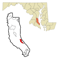
Location of St. Leonard, Maryland
|
|
| Country | |
| State | |
| County | |
| Area | |
| • Total | 2.31 sq mi (5.99 km2) |
| • Land | 2.29 sq mi (5.92 km2) |
| • Water | 0.03 sq mi (0.07 km2) |
| Elevation | 108 ft (33 m) |
| Population
(2020)
|
|
| • Total | 778 |
| • Density | 340.48/sq mi (131.46/km2) |
| Time zone | UTC−5 (Eastern (EST)) |
| • Summer (DST) | UTC−4 (EDT) |
| FIPS code | 24-69675 |
| GNIS feature ID | 0591216 |
St. Leonard is a small community in Calvert County, Maryland, in the United States. It is known as a "census-designated place" (CDP). This means it's an area identified by the U.S. Census Bureau for collecting statistics. In 2020, about 778 people lived here. Some nearby communities, like Calvert Beach and Long Beach, also use the St. Leonard ZIP code.
Contents
Exploring St. Leonard's Past
St. Leonard has a small downtown area. You can find several shops, gas stations, and a local grocery store there. The town also has a volunteer fire department. This department has hosted many famous music groups in the past. Bands like Lynyrd Skynyrd, Alan Jackson, and Hootie and the Blowfish have played concerts at an outdoor stage next to the fire department.
There are fun places to visit near St. Leonard. One is Flag Ponds Nature Park. It's a nature preserve located south of Long Beach, right along the Chesapeake Bay. Another great spot is Jefferson Patterson State Park, about 7 miles (11 km) south of town. This park hosts an annual Celtic festival. It is also home to Maryland's state archaeology center. The park is also famous for being the site of important naval battles. These battles happened in the Patuxent River during the War of 1812.
Where is St. Leonard?
St. Leonard is located in the southeastern part of Calvert County. Its exact location is 38°28′23″N 76°30′13″W / 38.47306°N 76.50361°W. The community of Calvert Beach is to its east. Long Beach is to its southeast.
Maryland Routes 2 and 4 run along the western side of St. Leonard. These roads lead north about 6 miles (10 km) to Prince Frederick. Prince Frederick is the main town in Calvert County. If you go south on these roads for about 13 miles (21 km), you will reach Solomons. Maryland Route 765 (St. Leonard Road) is an older main road that goes through the center of the community.
The United States Census Bureau says that St. Leonard covers a total area of about 2.3 square miles (6.0 square kilometers). Most of this area, about 2.29 square miles (5.9 square kilometers), is land. Only a small part, about 0.03 square miles (0.1 square kilometers), is water.
Who Lives in St. Leonard?
| Historical population | |||
|---|---|---|---|
| Census | Pop. | %± | |
| 2020 | 778 | — | |
| U.S. Decennial Census | |||
The most recent census in 2020 counted 778 people living in St. Leonard.
Based on the 2000 census, there were 536 people living in St. Leonard. There were 169 households and 142 families. The population density was about 165 people per square mile (64 people per square kilometer).
Out of all households, almost half (49.1%) had children under 18 living there. Most households (68.0%) were married couples living together. About 12.4% of households were people living alone.
The average age of people in St. Leonard was 32 years old. About 30.0% of the population was under 18. About 6.7% of the population was 65 years or older.
The average income for a household in St. Leonard was $67,188. For families, the average income was $62,321.
More to Explore
 In Spanish: St. Leonard (Maryland) para niños

