Salcha, Alaska facts for kids
Quick facts for kids
Salcha, Alaska
Soł Chaget, Saagescheeg
|
|
|---|---|

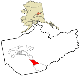
Location within Fairbanks North Star Borough and the state of Alaska
|
|
| Country | United States |
| State | Alaska |
| Borough | Fairbanks North Star |
| Area | |
| • Total | 77.06 sq mi (199.58 km2) |
| • Land | 75.28 sq mi (194.98 km2) |
| • Water | 1.78 sq mi (4.60 km2) |
| Elevation | 650 ft (200 m) |
| Population
(2020)
|
|
| • Total | 977 |
| • Density | 12.98/sq mi (5.01/km2) |
| Time zone | UTC-9 (Alaska (AKST)) |
| • Summer (DST) | UTC-8 (AKDT) |
| ZIP code |
99714
|
| Area code(s) | 907 |
| FIPS code | 02-66550 |
Salcha is a small community in Alaska, a state in the United States. It is known as a census-designated place (CDP). This means it's an area that looks like a town but doesn't have its own local government. The name Salcha comes from the Tanana language words Soł Chaget, and in Tanacross language it's Saagescheeg.
In 2020, about 977 people lived in Salcha. It's part of the larger Fairbanks, Alaska area.
Where is Salcha Located?
Salcha is found in the Fairbanks North Star Borough. It's about 40 miles (64 km) south of Fairbanks. You can find it along the Richardson Highway.
The community is right next to the Salcha River, which is a great spot for fishing. The larger Tanana River is also nearby. Salcha has its own post office, and its ZIP code is 99714.
The total area of Salcha is about 77 square miles (199.58 square kilometers). Most of this area is land, with a small part being water.
What is the Climate Like in Salcha?
Salcha has a very cold climate, known as a dry-winter continental subarctic climate. This means winters are long, very cold, and dry. Summers are short and cool.
| Climate data for Salcha | |||||||||||||
|---|---|---|---|---|---|---|---|---|---|---|---|---|---|
| Month | Jan | Feb | Mar | Apr | May | Jun | Jul | Aug | Sep | Oct | Nov | Dec | Year |
| Record high °F (°C) | 56 (13) |
50 (10) |
56 (13) |
76 (24) |
84 (29) |
92 (33) |
90 (32) |
90 (32) |
74 (23) |
62 (17) |
51 (11) |
49 (9) |
92 (33) |
| Mean daily maximum °F (°C) | 4.1 (−15.5) |
12.6 (−10.8) |
25.8 (−3.4) |
43.7 (6.5) |
60.7 (15.9) |
69.5 (20.8) |
71.1 (21.7) |
65.5 (18.6) |
54.2 (12.3) |
31.2 (−0.4) |
14.7 (−9.6) |
5.1 (−14.9) |
38.2 (3.4) |
| Mean daily minimum °F (°C) | −13.7 (−25.4) |
−9.7 (−23.2) |
−2.7 (−19.3) |
17.3 (−8.2) |
33 (1) |
44.6 (7.0) |
48.2 (9.0) |
43.3 (6.3) |
33.1 (0.6) |
15.4 (−9.2) |
−2.4 (−19.1) |
−12.7 (−24.8) |
16.1 (−8.8) |
| Record low °F (°C) | −65 (−54) |
−57 (−49) |
−49 (−45) |
−32 (−36) |
12 (−11) |
30 (−1) |
31 (−1) |
15 (−9) |
−2 (−19) |
−37 (−38) |
−37 (−38) |
−59 (−51) |
−65 (−54) |
| Average precipitation inches (mm) | 0.43 (11) |
0.37 (9.4) |
0.22 (5.6) |
0.24 (6.1) |
0.89 (23) |
2.37 (60) |
2.99 (76) |
2.19 (56) |
1.28 (33) |
0.94 (24) |
0.54 (14) |
0.54 (14) |
13.01 (330) |
| Average snowfall inches (cm) | 7.9 (20) |
6 (15) |
4.7 (12) |
2.9 (7.4) |
0.9 (2.3) |
0 (0) |
0 (0) |
0 (0) |
1.1 (2.8) |
11.4 (29) |
9.6 (24) |
10 (25) |
54.6 (139) |
| Average precipitation days | 6 | 5 | 4 | 4 | 8 | 12 | 14 | 13 | 10 | 9 | 8 | 7 | 100 |
Population of Salcha
| Historical population | |||
|---|---|---|---|
| Census | Pop. | %± | |
| 1980 | 319 | — | |
| 1990 | 354 | 11.0% | |
| 2000 | 854 | 141.2% | |
| 2010 | 1,095 | 28.2% | |
| 2020 | 977 | −10.8% | |
| U.S. Decennial Census | |||
Salcha first appeared on the U.S. Census in 1980. At that time, 319 people lived there. The population grew quite a bit over the years. In 2010, it reached 1,095 people. By 2020, the population was 977.
In 2000, there were 854 people living in Salcha. About 36% of the homes had children under 18. The average age of people living in Salcha was 38 years old.
See also
 In Spanish: Salcha para niños
 | George Robert Carruthers |
 | Patricia Bath |
 | Jan Ernst Matzeliger |
 | Alexander Miles |

