
Salem, Alabama facts for kids
Quick facts for kids
Salem, Alabama
|
|
|---|---|

The Y'all Come Novelty Shop in Salem's business district
|
|

Salem, Alabama
Location in Alabama

Salem, Alabama
Location in the United States
|
|
| Country | United States |
| State | Alabama |
| Counties | Lee |
| Area | |
| • Total | 115.3 sq mi (299 km2) |
| Population
(July 2007)
|
|
| • Total | 6,428 |
| • Density | 66/sq mi (25/km2) |
| Time zone | UTC-6 (CST) |
| • Summer (DST) | UTC-5 (CDT) |
| ZIP code |
36874
|
| Area code(s) | 334 |
| GNIS feature ID | 126233 |
Salem is a small community in Lee County, Alabama, in the United States. It's called an "unincorporated community" because it doesn't have its own local government, like a city or town. Salem is located along two main roads, U.S. Routes 280 and 431. These roads connect it to nearby cities like Opelika and Phenix City. Salem is also considered part of the larger Auburn Metropolitan Area.
History of Salem
Salem was first settled in 1835. It grew very quickly over the next 20 years. In 1846, Salem officially became a town with its own government. It was one of the biggest towns in the area at that time.
However, things changed after a big fire in 1854. This fire destroyed much of the town. Then, the Civil War (1861-1865) caused more problems. The town's government stopped working, and many people moved away.
In 1865, when Lee County was formed, Salem tried to become the county seat (the main town where the county government is). But it lost the bid. Over the next few decades, Salem's town government became inactive. Today, Salem is a small unincorporated community with only a few hundred people.
The Salem-Shotwell Covered Bridge
By the late 1900s, Salem was known for having the only covered bridge in Lee County. This bridge was called the Salem-Shotwell Covered Bridge. It was a special symbol of the area. Sadly, in 2005, a storm caused a tree to fall on the bridge, destroying it. But don't worry! The bridge was rebuilt in 2007. You can now see it at Opelika Municipal Park in nearby Opelika.
A post office first opened in Salem in 1839.
Tornado of 2009
On February 28, 2009, a strong tornado hit Salem. It touched down around 8:30 in the morning. This tornado was an EF2 tornado, which means it had very strong winds.
The tornado caused a lot of damage. It destroyed the Salem Chapel AME church and several homes. Part of Wacoochee Junior High School was also damaged. The Anglican Church of the Resurrection, which had just been finished in 2008, was also destroyed. This church was in a building that many people knew as the old McLain Museum.
The tornado moved east-northeast across U.S. Highway 280, which goes through Salem. It then lifted up about two miles to the east. Luckily, no one died, and there were no major injuries reported.
Gallery
-
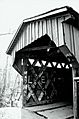
The Salem-Shotwell Covered Bridge in Salem, Alabama as it looked in 2003.
-

The falls at Moffit's Mill on Uchee Creek near Salem.
-
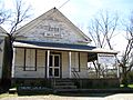
Dr. Andrew McLain's Office & Drug Store. This building was destroyed by the 2009 tornado. It was listed on the National Register of Historic Places.


Notable People
- Lil Cory, a Rapper
