
Samangan Province facts for kids
Quick facts for kids
Samangan Province
سمنگان
|
|
|---|---|

Samangan Province
|
|

Location of Samangan within Afghanistan
|
|
| Country | |
| Capital | Samangan |
| Area | |
| • Total | 11,262 km2 (4,348 sq mi) |
| Population
(2009)
|
|
| • Total | 350,400 |
| • Density | 31.113/km2 (80.584/sq mi) |
| Time zone | UTC+04:30 (AST) |
| Main language(s) | Dari Persian, Uzbek |
Samangan (Persian: سمنگان) is a province in the northern part of Afghanistan. It is one of the 34 provinces that make up the country. In 2006, about 313,211 people lived here. The main city and capital of Samangan Province is also called Samangan. The province is known for its beautiful landscapes and historical sites.
Contents
Understanding Samangan's Geography
Samangan Province is located in a key area of Afghanistan. It shares borders with several other provinces. To the north, it borders Balkh Province. To the northeast, you'll find Kunduz Province. Baghlan Province is to the east, and Bamyan Province is to the south. To the west, it borders Sar-e Pol Province. This location makes Samangan an important link between different regions.
 |
Balkh Province | Kunduz Province | |
|
| Sar-e Pol Province | Baghlan Province | |||
| Bamyan Province |
Districts and Their Communities
Samangan Province is divided into several smaller areas called districts. Each district has its own capital city or main town. These districts help manage the local communities and services. Here is a list of the districts in Samangan Province, along with their capitals and populations:
| District | Capital | Population | Area | Notes |
|---|---|---|---|---|
| Aybak | Aybak, Samangan | 85,427 | 909.91676 | |
| Darah Sof Balla | Darah Sof Balla | 52,473 | Created in 2005 within Darah Sof District | |
| Darah Sof Payan | Darah Sof Payan | 55,858 | 4539.27567 | Created in 2005 within Darah Sof District |
| Feroz Nakhchir | Feroz Nakhchir | 11,701 | Created within Khulmi District and shifted from Balkh Province in 2005 | |
| Hazrati Sultan | Hazrati Sultan | 36,690 | 1223.92574 | |
| Khuram Wa Sarbagh | Khuram Wa Sarbagh | 30,704 | ||
| Ruyi Du Ab | Ruyi | 40,358 |
Historical and Cultural Sites
Samangan Province is home to interesting historical places. One of the most famous is a Buddhist stupa and monastery. A stupa is a special dome-shaped building used for meditation or as a shrine. What makes this one unique is that it was carved out of the rock, so it's actually below ground level! There are also five caves nearby that were once used by monks for meditation. These sites show the rich history of the region.
Life and Agriculture in Samangan
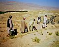
Many people in Samangan Province work in agriculture. They grow crops in the flat fields, often with mountains in the background. Pistachio farming is an important part of the local economy. Sometimes, people in the villages receive food aid to help support their families. The Khulm River basin is also important for the region's water supply.
Images for kids
-
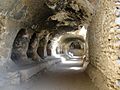
Below Buddhist stupa is a series of five caves, former monks’ cells for meditation.
-
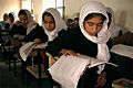
Samangan School
-
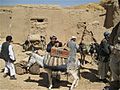
Villagers in Samangan province receiving food parcels
-
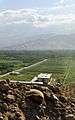
Flat agricultural fields with mountains in the background
-
Pistachio farmers
-
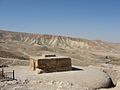
Remains of the Buddhist stupa and monastery on a hill above Samangan. Instead of being built up, it has been carved out of the rock so is completely below ground level!
-
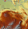
Map of the Khulm River basin


See also
 In Spanish: Provincia de Samangán para niños
