San Andrés Sajcabajá facts for kids
Quick facts for kids
San Andrés Sajcabajá
|
|
|---|---|
|
Municipality
|
|

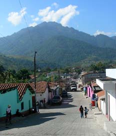
Street scene in San Andrés Sajcabajá, November 2006
|
|
| Country | |
| Department | |
| Municipality | San Andrés Sajcabajá |
| Government | |
| • Type | Municipal |
| Area | |
| • Municipality | 446 km2 (172 sq mi) |
| Elevation | 1,200 m (3,900 ft) |
| Highest elevation | 2,200 m (7,200 ft) |
| Lowest elevation | 1,000 m (3,000 ft) |
| Population
(Census 2002)
|
|
| • Municipality | 19,035 |
| • Urban | 1,875 |
| • Ethnicities | K'iche' (89%) Ladino (11%) |
| • Religions | Roman Catholicism Evangelicalism Maya |
| Climate | Am |
| Website | Site |
San Andrés Sajcabajá is a town and a municipality in Guatemala. It is located in the El Quiché area of the country. The municipality includes the main town of San Andrés Sajcabajá and 62 smaller communities in the countryside. Most of the people living here, about 89%, are from the K'iche' ethnic group.
Contents
History of San Andrés Sajcabajá
Early History and Spanish Arrival
Before the Spanish arrived, this area was known as Sajcabajá. It was home to different groups of people from the K'iche' Kingdom of Q'umarkaj. After the K'iche' people were defeated, Spanish rule began in Sajcabajá between 1552 and 1580.
The Dominican religious group from Sacapulas was in charge of teaching Christianity to the local people. They used a system called reducciones. This system gathered people into new, organized towns.
Colonial Era and Municipality Status
During the time of Spanish rule, San Andrés Sajcabajá was an important stop. It was located on a main road, called the camino real. This road connected Joyabaj and Sacapulas. It also linked the capital city of Guatemala, which was then in Tecpán, to Chiapas.
San Andrés Sajcabajá officially became a municipality in 1892. This meant it gained its own local government.
Recent Challenges and Community Impact
More recently, San Andrés Sajcabajá faced difficulties during the 36-year Guatemalan civil war (1960–1996). The years between 1981 and 1984 were especially tough. During this time, the Guatemalan army set up a military base in the town's Catholic church building. This led to a period of great challenges for the people living there.
Geography and Environment
Location and Climate
The municipality of San Andrés Sajcabajá is found within the Sierra de Chuacús mountain range. The town and its many small communities are located at different heights. They are between 1,000 and 2,000 meters (about 3,280 to 6,560 feet) above sea level.
The climate here is mild, or temperate. Temperatures usually stay between 12°C and 24°C (54°F and 75°F). The area also receives a good amount of rain each year, typically between 1,000 and 2,000 millimeters (about 39 to 79 inches).
Land Use and Farming
Because the area is very mountainous, more than 77% of the land is too steep for most types of farming. This land is mainly used for growing trees and forests.
The main crops grown for food are maize (corn) and beans. These are grown by local farmers to feed their families. Some communities also grow vegetables, but only if they have access to water for irrigation. These vegetables include tomatoes, onions, cabbage, squash, and güisquil (chayote). These fresh products are then sold in the local market.
See also
 In Spanish: San Andrés Sajcabajá para niños
 | Aurelia Browder |
 | Nannie Helen Burroughs |
 | Michelle Alexander |


