
San Fernando, Chile facts for kids
Quick facts for kids
San Fernando
|
|||||
|---|---|---|---|---|---|
.jpg)
San Fernando's central plaza.
|
|||||
|
|||||
| Country | |||||
| Region | |||||
| Province | |||||
| Founded | 1742 | ||||
| Founded by | José Antonio Manso de Velasco | ||||
| Government | |||||
| • Type | Municipality | ||||
| Area | |||||
| • Total | 2,441.3 km2 (942.6 sq mi) | ||||
| Elevation | 89 m (292 ft) | ||||
| Population
(2017 Census)
|
|||||
| • Total | 73,973 | ||||
| • Density | 30.3007/km2 (78.4783/sq mi) | ||||
| Demonym(s) | Sanfernandino/a | ||||
| Sex | |||||
| • Men | 36,077 | ||||
| • Women | 37,896 | ||||
| Time zone | UTC-4 (CLT) | ||||
| • Summer (DST) | UTC-3 (CLST) | ||||
| Postal code |
3070000
|
||||
| Area code(s) | +56 72 | ||||
| Website | Official website: https://www.munisanfernando.cl/ | ||||
.svg)


San Fernando is a city in central Chile. It's the main city of Colchagua Province and the second biggest city in the O'Higgins Region. It's located in a rich valley near the Tinguiririca River. The city is about 89 meters (292 feet) above sea level. San Fernando was founded in 1742 and became the capital of its province in 1840.
Contents
What Makes San Fernando Special?
San Fernando is well-known for its rodeos. Rodeos are a traditional sport in Chile, similar to cowboy competitions. The city is in the heart of Chile's farming country.
Farming and Food
The land around San Fernando is very fertile. Farmers here grow many crops. These include wheat, rice, and different types of beans. They also grow grapes for making Chilean wine. There's even a special wine brand called San Fernando.
Many companies that export fresh fruit are located near San Fernando. These include Frusan, Unifruti, and Agricola Panagro. You can find almost every kind of fresh fruit and vegetable grown here. This ranges from citrus fruits to high-quality fresh cherries.
Travel and Transport
Two major routes pass through San Fernando. The Pan-American Highway is a very long road that connects many countries. Chile's main railroad also runs through the city.
The Wine Route
San Fernando is at the top of Chile's Colchagua Valley. This area is famous for its vineyards. You can follow the "wine route" from San Fernando to Santa Cruz. Along the way, you can visit some of Chile's oldest vineyards.
Places to Visit
There are several interesting places to see in and around San Fernando:
- Casa Silva: This is a hotel, vineyard, and winery. It's a great place to learn about wine.
- Hacienda Los Lingues: This is a traditional Chilean-style house. It used to be owned by a wealthy landowner. Now, it's a hotel and restaurant. You can even go horseback riding into the Andes mountains from here.
Las Termas Del Flaco
San Fernando is also the starting point for trips to "Las Termas Del Flaco." These are natural hot springs. You can reach them by traveling east from the main highway towards Puente Negro. The hot springs are open from mid-December to April. This area is also famous for its large groups of Tricahue parrots. You can also find fossilized dinosaur footprints there!
Population and People
In 2017, a survey counted the people living in San Fernando. The city covers an area of about 2,441.3 km2 (943 sq mi). There were 73,973 people living there. This included 36,077 men and 37,896 women. The population grew by 16.1% between 2002 and 2017. People from San Fernando are called Sanfernandino/a.
How San Fernando is Governed
San Fernando is a commune, which is a type of local government area in Chile. It is managed by a municipal council. The council is led by a mayor. The mayor is chosen by the people in an election every four years. The current mayor is Pablo Silva Pérez.
Weather in San Fernando
San Fernando has a mild climate. Here's a quick look at the average temperatures and rainfall:
| Climate data for Rengo | |||||||||||||
|---|---|---|---|---|---|---|---|---|---|---|---|---|---|
| Month | Jan | Feb | Mar | Apr | May | Jun | Jul | Aug | Sep | Oct | Nov | Dec | Year |
| Mean daily maximum °C (°F) | 29.8 (85.6) |
28.8 (83.8) |
26.2 (79.2) |
22.1 (71.8) |
18.8 (65.8) |
14.0 (57.2) |
13.8 (56.8) |
14.2 (57.6) |
18.4 (65.1) |
21.7 (71.1) |
24.0 (75.2) |
28.3 (82.9) |
21.7 (71.0) |
| Daily mean °C (°F) | 21.4 (70.5) |
20.2 (68.4) |
17.0 (62.6) |
13.6 (56.5) |
10.5 (50.9) |
7.6 (45.7) |
7.9 (46.2) |
8.5 (47.3) |
11.3 (52.3) |
14.4 (57.9) |
16.7 (62.1) |
20.1 (68.2) |
14.1 (57.4) |
| Mean daily minimum °C (°F) | 12.8 (55.0) |
11.6 (52.9) |
9.0 (48.2) |
6.7 (44.1) |
5.4 (41.7) |
2.5 (36.5) |
3.2 (37.8) |
3.6 (38.5) |
5.0 (41.0) |
7.7 (45.9) |
9.5 (49.1) |
11.5 (52.7) |
7.4 (45.3) |
| Average precipitation mm (inches) | 5.4 (0.21) |
9.3 (0.37) |
9.2 (0.36) |
16.6 (0.65) |
98.7 (3.89) |
157.6 (6.20) |
118.2 (4.65) |
100.4 (3.95) |
38.9 (1.53) |
24.3 (0.96) |
18.7 (0.74) |
3.4 (0.13) |
600.7 (23.64) |
| Average relative humidity (%) | 61 | 62 | 70 | 76 | 84 | 85 | 84 | 84 | 77 | 74 | 69 | 60 | 74 |
| Source: Bioclimatografia de Chile | |||||||||||||
Images for kids
-
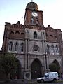
San Francisco Church.
-
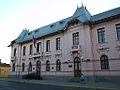
Gobernación de Colchagua.

,_2005.jpg)
See also
 In Spanish: San Fernando (Chile) para niños
