San Manuel Colohete facts for kids
Quick facts for kids
San Manuel Colohete
|
|
|---|---|
|
Municipality
|
|

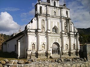
The Old Colonial Church of San Manuel de Colohete
|
|
| Country | Honduras |
| Department | Lempira |
| Municipality since | 2 February 1901 |
| Area | |
| • Municipality | 172 km2 (66 sq mi) |
| Population
(2015)
|
|
| • Municipality | 14,583 |
| • Density | 84.78/km2 (219.6/sq mi) |
| • Urban | 1,500 |
San Manuel Colohete is a town and municipality in Honduras. It is located in the Lempira department. You can find it about 20 miles southwest of Gracias, the capital city of the department.
The whole municipality has about 15,000 people. Around 1,500 people live in the main town center. A famous building here is the old Spanish church. It was built in the late 1600s. The church has seven statues of saints on its front. Inside, you can still see original paintings made with mud-based paint. There is also a beautiful carved and gold-covered altar. Some parts of the church have been fixed recently.
San Manuel Colohete is also on a popular route for hikers. These hikers are often going to or coming from Celaque. Celaque is the tallest mountain in Honduras. You can see this huge mountain from many places around San Manuel.
Contents
History of San Manuel Colohete
In 1887, San Manuel Colohete was a small settlement. It was part of a village called "Concepcion Colohete." This village was then part of the Gracias municipality.
On February 2, 1901, San Manuel Colohete became its own municipality. This happened during the time Terencio Sierra was in charge. The name "Colohete" comes from an old Indian language. It means "Cradle of Scorpions." Long ago, brave warriors of the chief Lempira lived in this area.
Geography and Nature
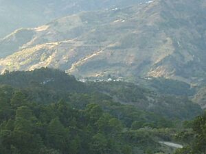
San Manuel Colohete is in a flat area. This flat part is surrounded by mountains. The plants and trees here are quite varied.
- Pine forests: You can find tall pine trees.
- Dry subtropical forests: These forests have plants that can live in drier weather.
- Bushes and undergrowth: Some hills are covered only with small bushes and low plants.
The mountains and hills around the main town are very steep. The weather is usually cool. However, it can get warm during the summer. The villages and smaller settlements are in large dips in the land around the main town.
Where San Manuel Colohete Is Located
San Manuel Colohete shares its borders with several other places:
- North: It borders the Gracias municipality.
- South: It borders the municipalities of La Campa and San Sebastián.
- East: It borders the La Campa municipality.
- West: It borders the San Sebastián municipality and the Ocotepeque department.
The total area of San Manuel Colohete is 172 square kilometers.
Local Resources and Economy
San Manuel Colohete is a great place to grow coffee. This is because it is high up from the sea. Farmers also grow a lot of beans and corn here.
The main town has electricity. People can also use mobile phones. Raising cattle is mostly for the people who live here. Some homes sell gasoline and diesel fuel. There is also a small quarry that digs for limestone. You can see it on the way to the town center.
Population Information
In 2001, the population was 10,908 people. By 2015, it was estimated to be 14,583 people.
- Villages: There are 10 villages in the municipality.
- Settlements: There are 85 smaller settlements.
People of San Manuel Colohete
A census in 2013 showed the population was 14,063 people. Most of the people are Indigenous. About 96% are Lenca people. A small number, about 3.7%, are Mestizo (people of mixed European and Indigenous background). Very few people are Black or Afro-Honduran or from other groups.
Fun Things to Do and See
- Local holidays: The town celebrates La Concepción Inmaculada (The Immaculate Conception) on December 8th. San Manuel was once known as Concepción Colohete.
See also
 In Spanish: San Manuel Colohete para niños
 | Aurelia Browder |
 | Nannie Helen Burroughs |
 | Michelle Alexander |


