San Pedro de Quemes Municipality facts for kids
Quick facts for kids
San Pedro de Quemes
|
|
|---|---|
|
Municipality
|
|

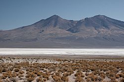
Salar de Chiguana
|
|

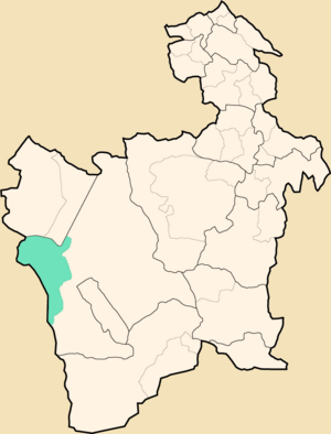
Location within Potosí Department
|
|
| Country | |
| Department | Potosí Department |
| Province | Nor Lípez Province |
| Seat | San Pedro de Quemes |
| Area | |
| • Total | 1,657 sq mi (4,291 km2) |
| Elevation | 13,000 ft (4,000 m) |
| Population
(2001)
|
|
| • Total | 815 |
| • Ethnicities | Quechua |
| Time zone | UTC-4 (BOT) |
San Pedro de Quemes (which is called Qimis in the Quechua language) is a town and a municipality in Bolivia. It is located in the Potosí Department, which is like a state or province. The town of San Pedro de Quemes is the main place in this municipality. It is the second largest municipal section of the Nor Lípez Province.
Contents
Exploring the Geography of San Pedro de Quemes
The municipality of San Pedro de Quemes is found near the famous Salar de Uyuni. This is a huge salt flat, one of the largest in the world.
Mountains and Volcanoes
Many tall mountains and volcanoes are located in this area. Some of these natural features also form part of the border with Chile.
Here are some of the highest mountains in the municipality:
- Araral
- Chiwana
- Ch'aska Urqu
- Iru Phutunqu
- Julina
- Kachi Unu
- K'uchu Unu
- Luxsar
- Michincha
- Millu Urqu
- Paruma
- Patilla
- Phuruncha
- Q'aluta Wintu Luma
- Sarapuru
- Tankani
- Tirani
- Ukilla
- Ullawi
- Ullqa
- Wanaku
- Yarita
Understanding the Municipality's Divisions
The municipality is divided into different smaller areas called cantons. Each canton has its own number of residents.
Here are the cantons and their populations from 2001:
- Cana - 44 inhabitants
- Chiguana - 10 inhabitants
- Pajancha - 52 inhabitants
- Pelcoya - 135 inhabitants
- San Pedro de Quemes - 574 inhabitants
The People of San Pedro de Quemes
Most of the people living in San Pedro de Quemes are not from indigenous groups. However, a large part of the population, about 45%, are people of Quechua descent.
Here is a breakdown of the different ethnic groups:
| Ethnic group | % |
|---|---|
| Quechua | 45.0 |
| Aymara | 6.3 |
| Guaraní, Chiquitos, Moxos | 0.2 |
| Not indigenous | 48.3 |
| Other indigenous groups | 0.2 |
See also
 In Spanish: San Pedro de Quemes para niños
 | DeHart Hubbard |
 | Wilma Rudolph |
 | Jesse Owens |
 | Jackie Joyner-Kersee |
 | Major Taylor |


