
Ollagüe facts for kids
Quick facts for kids Ollagüe |
|
|---|---|

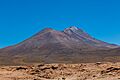
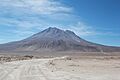
Ollagüe as viewed from the west.
|
|
| Highest point | |
| Elevation | 5,868 m (19,252 ft) |
| Prominence | 1,686 m (5,531 ft) |
| Listing | Ultra |
| Naming | |
| Native name | Error {{native name}}: an IETF language tag as parameter {{{1}}} is required (help) |
| Geography | |

Ollagüe
Location in Bolivia
|
|
| Location | Potosí Department, Nor Lípez Province, Pelcoya Canton, Bolivia - Antofagasta Region, El Loa Province, Chile |
| Parent range | Andes |
| Geology | |
| Age of rock | Pleistocene |
| Mountain type | Stratovolcano |
| Last eruption | 65,000 years ago |
Ollagüe, also known as Ullawi, is a large stratovolcano located in the Andes mountains. It sits right on the border between Bolivia and Chile. Its highest point is 5,868 meters (about 19,252 feet) above sea level.
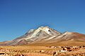
This volcano has a crater at its top that opens towards the south. On the western side of the crater, there are several lava domes. The newest of these domes has a strong fumarole, which is like a steam vent. You can see this steam from far away!
Ollagüe is very old, mostly formed during the Pleistocene era. It started growing over a million years ago. During its early stages, it created many lava flows. Over time, parts of the volcano collapsed, causing huge landslides. Later, new volcanic activity filled in these collapsed areas.
Even though there's no clear record of Ollagüe erupting recently, it's considered an active volcano. It is watched by the National Geology and Mining Service (SERNAGEOMIN) in Chile. The volcano also has sulfur deposits, which have been mined in the past.
Contents
What's in a Name?
The original name for the volcano in the Aymara language was Ullawi. This name comes from the Aymara word ullaña, which means "to see" or "to watch." So, Ullawi means "viewpoint."
The more common name today is Ollagüe. Other names you might hear are Oyague, Ollagua, and Oyahué.
Where is Ollagüe?
Ollagüe sits right on the border between Chile and Bolivia. Most of the volcano is on the Bolivian side. The Chilean part is in the Ollagüe commune. The Bolivian part is in the Potosí Department.
Some towns and places near Ollagüe include Amincha, Buenaventura, Cosca, El Chaco, and Santa Rosa. A main road runs along the western side of the volcano. People have reported seeing warning signs about minefields in the area.
Volcanoes in the Andes
Ollagüe is part of the Central Volcanic Zone (CVZ). This is one of several chains of volcanoes in the Andes mountains. Volcanoes form here because the Nazca Plate (an oceanic plate) is sliding beneath the South America Plate (a continental plate). This process is called subduction. As the oceanic plate sinks, it releases water and other materials. These materials cause the rock above to melt, forming magma. This magma then rises to the surface, creating volcanoes.
The Central Volcanic Zone has about 1,100 volcanoes. Many of these volcanoes are very tall, over 5,500 meters (about 18,000 feet) high. The Earth's crust is very thick here, up to 70 kilometers (about 43 miles). This thick crust can mix with the rising magma, changing its composition.
Ollagüe's Shape and Features
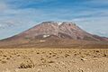
Ollagüe is a stratovolcano, which means it's a cone-shaped volcano built up by many layers of hardened lava, ash, and rock. It often has snow on its slopes, and its yellow and red colors make it look beautiful. The dry climate in this region means the volcano's shape is very well preserved.
Ollagüe has two main peaks: Ollagüe South (5,868 meters high) and Ollagüe North (5,863 meters high). The main crater is about 300 meters (984 feet) below the summit. The western edge of this crater is made of several lava domes.
The volcano also has smaller vents on its sides. These include Ch'aska Urqu on the southeast and La Celosa on the northwest. These smaller vents suggest that magma sometimes travels along cracks in the Earth's crust to erupt on the volcano's slopes.
Nearby, you can find large salt flats like the Salar de Ollague and the Salar de San Martin. These salt flats are at elevations of about 3,690 to 3,694 meters (about 12,100 to 12,120 feet).
Past Ice Ages
Today, it's too dry and sunny for glaciers to form on Ollagüe. However, the volcano shows signs of past glaciers. You can find moraines, which are piles of rocks and dirt left behind by glaciers. These moraines are found on the lower slopes and near the summit. This tells us that Ollagüe was once covered by ice during colder periods, like the Little Ice Age.
Giant Landslides
Ollagüe has experienced huge landslides, also called sector collapses. One major collapse happened on the western side of the volcano. Debris from this landslide flowed for 16 kilometers (about 10 miles) into the nearby salt flats. This landslide deposit covers about 100 square kilometers (about 38 square miles) and has a bumpy surface.
Scientists believe this collapse happened around 292,000 years ago. It might have been caused by the volcano growing too tall and becoming unstable. Magma pressure inside the volcano could have also triggered the collapse. The collapse left a large scar on the volcano's side, but new lava flows later filled it in.
Older landslides also occurred on Ollagüe about 450,000 years ago. These collapses were also influenced by cracks in the Earth's crust.
What is Ollagüe Made Of?
The rocks from Ollagüe are mostly andesite and dacite. These rocks are rich in crystals. Scientists study these crystals to understand how the magma formed deep inside the Earth.
There are also areas on Ollagüe where the rocks have been changed by hot water and steam. This process is called hydrothermal alteration. It has created deposits of sulfur, alunite, and gypsum on the volcano.
The magma inside Ollagüe's main chamber was very hot, ranging from 825 to 1000 degrees Celsius (1517 to 1832 degrees Fahrenheit). Over time, the magma became cooler. Sometimes, new, hotter magma would enter the chamber, reheating it.
Steam Vents (Fumaroles)
A large fumarole is active at the summit of Ollagüe. Its plume of steam and gas can rise up to 100 meters (about 328 feet) high. It's so strong that you can see it from more than 10 kilometers (about 6 miles) away!
The gases from this fumarole are mainly water vapor and sulfur dioxide. Smaller amounts of carbon dioxide are also present. Scientists measure how much sulfur dioxide is released. In 2013, it was about 150 tons per day.
When Did Ollagüe Erupt?
Scientists have used special dating methods to figure out when Ollagüe erupted. Most of its activity happened over the last million years.
The volcano's growth is divided into stages:
- Ollagüe I: Between 1.2 million and 900,000 years ago.
- Ollagüe II: Between 900,000 and 600,000 years ago.
- Ollagüe III: From 400,000 years ago to the present.
The oldest activity, called Vinta Loma and Santa Rosa, formed most of the volcano's main body. During this time, lava flows and some explosive eruptions occurred.
Later, new lava flows and domes formed on the volcano's sides, like the Ch'aska Urqu and La Celosa areas. These eruptions happened from different vents around the volcano.
After the main landslide, new lava flows and domes filled the collapse scar. The youngest of these lava domes is about 65,000 years old.
Recent Activity and Dangers
While Ollagüe hasn't had a major eruption in recorded history, it is still considered potentially active because of its strong fumarole. There were uncertain reports of eruptions in 1903 and 1927. Increased steam activity was noted in 1854, 1888, 1889, and 1960.
The Chilean National Geology and Mining Service (SERNAGEOMIN) monitors Ollagüe. If it were to erupt, it could affect the nearby town of Ollagüe and the main highway.
Sulfur Mining
Ollagüe has rich sulfur deposits, which were mined for many years. The Santa Cecilia and Santa Rosa mines were located on the volcano. In 1990, it was estimated that the Santa Rosa mine had about 3 million tons of sulfur.
Large-scale mining began in the late 1800s. Sulfur was needed for the saltpeter and copper industries. Mining continued until the 1990s, when it became too expensive to compete in the global market.
A road was built up to 5,500 meters (about 18,000 feet) high to reach the mines. Sulfur was transported by an aerial tramway, which replaced llamas! There were also processing plants and railway stations nearby.
Most of the mining was done by local indigenous workers. They were better adapted to the harsh conditions at high altitudes, like the cold, strong winds, and thin air. Today, much of the old mining infrastructure is in ruins. Since 2015, a project has been working to record and preserve the history of sulfur mining in this region.
Images for kids
-
-

Fumarole clearly visible
-
-
-
-
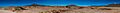
Panoramic image, with Ollagüe in the centre
-
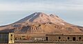
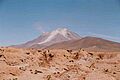
Ollagüe from the town of the same name, the La Celosa lava domes are in the foreground
-


See also
 In Spanish: Volcán Ollagüe para niños
- Aucanquilcha
- Olca
- List of volcanoes in Bolivia
- List of volcanoes in Chile
