
San Vittore, Switzerland facts for kids
Quick facts for kids
San Vittore
|
||
|---|---|---|
 |
||
|
||

San Vittore
Location in Switzerland

San Vittore
Location in Canton of Graubünden
|
||
| Country | Switzerland | |
| Canton | Graubünden | |
| District | Moesa | |
| Area | ||
| • Total | 22.06 km2 (8.52 sq mi) | |
| Elevation | 278 m (912 ft) | |
| Population
(Dec 2020 )
|
||
| • Total | 864 | |
| • Density | 39.166/km2 (101.44/sq mi) | |
| Postal code |
6534
|
|
| Surrounded by | Arvigo, Buseno, Castaneda, Claro (TI), Cresciano (TI), Germasino (IT-CO), Lumino (TI), Roveredo | |

San Vittore is a small town, also called a municipality, in the Moesa Region of Switzerland. It is located in the canton of Grisons (Graubünden).
Contents
Geography of San Vittore

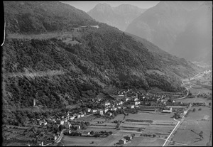
San Vittore is found in the lower part of the Moesa river valley. It's only about 2 km (1.2 mi) away from the border of the canton of Ticino. The town is also about 6 km (3.7 mi) upstream from Arbedo-Castione, where the Moesa river joins the Ticino river.
At 278 meters (912 ft) above sea level, San Vittore is the lowest town in the Graubünden canton.
The area of San Vittore is about 22 km2 (8.5 sq mi). A good part of this land, 15.5%, is used for farming. A much larger part, 66.7%, is covered by forests. About 2.8% of the land has buildings or roads. The remaining 15% is made up of things like rivers, glaciers, or mountains that aren't used for farming or building.
Population and People
San Vittore has a population of 864 people. About 14.2% of the people living there are from other countries. Over the last 10 years, the number of people in San Vittore has grown by 16.2%.
Most people in San Vittore speak Italian, which is 88.7% of the population. German is the second most common language at 7.6%, and French is third at 1.1%.
In 2000, the population was almost equally split between males and females. About 12.5% of the people were children aged 0 to 9. Teenagers aged 10 to 19 made up about 8.6% of the population.
When it comes to education, about 73.5% of adults (aged 25-64) in San Vittore have finished high school or gone on to higher education, like university.
San Vittore has a low unemployment rate of 2.06%. This means most people who want to work can find jobs.
Jobs and Economy
The jobs in San Vittore are divided into three main types:
- Primary sector: This includes jobs like farming. In 2005, 23 people worked in this area, with about 10 businesses.
- Secondary sector: This involves making things, like in factories or construction. There were 129 people working in this sector, with 13 businesses.
- Tertiary sector: These are service jobs, like working in shops, offices, or tourism. 68 people worked in this sector, with 23 businesses.
Population Changes Over Time
Here's how the population of San Vittore has changed over many years:
| year | population |
|---|---|
| 1850 | 594 |
| 1900 | 517 |
| 1950 | 468 |
| 1960 | 516 |
| 1970 | 666 |
| 1980 | 555 |
| 1990 | 611 |
| 2000 | 657 |
Important Historical Sites

San Vittore has some very important historical places. These are called heritage sites of national significance. They are protected because they are a big part of Switzerland's history and culture.
Two of these special sites are:
- The Chapel of S. Lucio e dintorni (a chapel and its surroundings)
- The Torre di Pala (a historic tower)
See also
 In Spanish: San Vittore para niños
