Sanchez Reservoir facts for kids
Quick facts for kids Sanchez Reservoir |
|
|---|---|

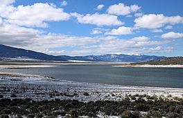
Looking south across the reservoir.
|
|
| Location | Costilla County, Colorado |
| Coordinates | 37°05′02″N 105°24′52″W / 37.08389°N 105.41444°W |
| Type | reservoir |
| Primary inflows | Ventero Creek Sanchez Canal |
| Basin countries | United States |
| Managing agency | Sanchez Ditch and Reservoir Company |
| Designation | Sanchez Reservoir State Wildlife Area |
| Built | 1912 |
| First flooded | 1912 |
| Surface area | 3,145 acres (1,273 hectares) |
| Water volume | 103,000 acre-feet (127,000,000 cubic meters) |
| Surface elevation | 2,518 meters (8,261 feet) |
Sanchez Reservoir is a large lake located in southcentral Colorado. It sits west of the beautiful Sangre de Cristo Mountains in Costilla County.
This reservoir gets its water from Ventero Creek and the Sanchez Canal. The Sanchez Canal is a special channel that brings water from Culebra Creek and two other creeks into the reservoir.
Contents
Sanchez Reservoir: A Colorado Lake
Sanchez Reservoir is an important man-made lake in Colorado. It helps store water for the area. The reservoir is also a popular spot for outdoor activities.
Where is Sanchez Reservoir?
This large body of water is found in the southern part of Colorado. It is in Costilla County, which is a county in the state. The reservoir is located to the west of the tall Sangre de Cristo Mountains.
How Was the Reservoir Built?
The dam that holds back the water for Sanchez Reservoir was built a long time ago. It was finished in 1912. The dam is made of earth.
Because of some leaks in the dam, the reservoir does not always fill up completely. Also, the area sometimes has droughts. A drought means there is not enough rain. This also keeps the reservoir from reaching its full size.
Fishing Fun and Safety
Many people enjoy fishing at Sanchez Reservoir. The Colorado Parks and Wildlife group helps manage fishing here. The reservoir is part of the Sanchez Reservoir State Wildlife Area.
It's important to know about fish safety. The Colorado Department of Public Health and Environment has given a special warning. This warning is about eating certain fish from the lake. It says that northern pike and walleye caught here might have unsafe levels of mercury.


