Sandy Bay, Gibraltar facts for kids
Quick facts for kids Sandy Bay |
|
|---|---|
 |
|
| Location | |
| Country | Gibraltar |
| Location | Gibraltar |
| Coordinates | 36°07′52″N 5°20′29″W / 36.131058°N 5.341514°W |
| Details | |
| Owned by | Government of Gibraltar |
| Type of harbor | Natural/Artificial |
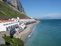
Sandy Bay is a small village, bay, and beach located on the eastern side of Gibraltar. It sits on the Mediterranean Sea coast, opposite the main city and the Rock of Gibraltar. You can find it south of Catalan Bay, and it's easy to reach by following Sir Herbert Miles Road.
Contents
Collecting Water: The Old Catchments
Right above Sandy Bay, you can see where Gibraltar's large water catchments used to be. These were special areas designed to collect rainwater. They are no longer used today.
The slope where these catchments sat is called the Great Gibraltar Sand Dune. This is a very old, solid sand dune that covers most of the eastern side of the Rock of Gibraltar. Because the dune's surface was naturally smooth, it was a perfect spot to build a water collection system.
This system was made from corrugated steel sheets and a layer of concrete. When it rained, the water would flow down the slope. It then went into an open channel that led to large reservoirs built inside The Rock.
When Were the Reservoirs Built?
Work on four huge water reservoirs began in 1898. Each of these could hold 5 million gallons of water! They were carved right into the western side of The Rock. The Governor of Gibraltar, George Stuart White, officially opened them in 1901. These first reservoirs got their water from smaller collection areas on the western side of The Rock.
The larger water catchments above Sandy Bay were built over many years, from 1903 to 1961. They were needed because Gibraltar's demand for water kept growing. The first plan was to cover an area of 10 acres (40,000 m2) (about 40,000 square meters).
Between 1911 and 1914, a fifth reservoir was dug inside The Rock. The collection area also grew to 24 acres (97,000 m2) (about 97,000 square meters). By 1961, the total area for collecting water reached its biggest size: 34 acres (140,000 m2) (about 137,000 square meters).
Sandy Bay Today
In 2001, the Gibraltar Ornithological and Natural History Society started a project to remove the old water catchment structures. By 2006, the slope was completely returned to its natural state. Now, it's covered in plants that naturally grow in this special part of Gibraltar.
You can continue south along Sir Herbert Miles Road from Sandy Bay. This road goes through the Dudley Ward Tunnel all the way to Europa Point, which is the very southern tip of Gibraltar.
The Dudley Ward Tunnel was closed for a while after a rockfall in 2002. However, it was suggested in 2007 that the tunnel should reopen. This would help with traffic in the area, especially near the new homes being built around Rosia. After a lot of engineering work, the tunnel finally reopened in November 2010.
Sandy Bay is also home to one of the few places where people live on the east side of The Rock. This residential area is known as Both Worlds.
Making the Beach Better
On June 25, 2014, officials in Gibraltar celebrated the opening of the new Sandy Bay. A lot of public money was spent to improve the beach, which had almost disappeared.
The beach was made much bigger by adding about 50,000 tons of sand. This sand was brought all the way from Laayoune in the Western Sahara. To protect the new sand from waves, two curved walls called groynes were built. A breakwater was also constructed in front of the beach. This helps to stop the waves from washing away the sand. There's even a hidden breakwater underwater that connects the ends of the two groynes.
See also
 In Spanish: Sandy Bay para niños
 | Chris Smalls |
 | Fred Hampton |
 | Ralph Abernathy |

