
Rock of Gibraltar facts for kids
Quick facts for kids Rock of Gibraltar |
|
|---|---|

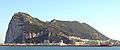
Western face of the Rock of Gibraltar, in April 2006
|
|
| Highest point | |
| Elevation | 426 m (1,398 ft) |
| Prominence | 423 m (1,388 ft) |
| Geography | |

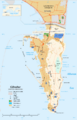
Location of the Rock of Gibraltar's summit
|
|
| Location | Gibraltar |
| Parent range | Betic Cordillera |
| Geology | |
| Age of rock | Jurassic |
| Climbing | |
| Easiest route | Gibraltar Cable Car, Road, Hike |
The Rock of Gibraltar, also called the Jabel-al-Tariq, is a huge limestone rock sticking out into the sea. It got its name from a Berber leader, Tariq ibn-Ziyad, who conquered Spain. This famous rock is found in Gibraltar, at the very end of Europe on the Iberian Peninsula. It stands 426 m (1,398 ft) tall!
Most of the top part of the Rock is a nature reserve. This reserve is home to about 300 Barbary macaques, which are a type of monkey. Many tourists visit each year to see these monkeys and explore the amazing network of tunnels inside the Rock.
Long ago, the Romans called the Rock of Gibraltar Mons Calpe. It was one of the two Pillars of Hercules. The other pillar was Mons Abyla or Jebel Musa in Africa, across the Strait. Ancient Greeks and Phoenicians believed these two pillars marked the edge of the known world. But the Phoenicians actually sailed much further into the Atlantic Ocean!
Gibraltar is surrounded by the Mediterranean Sea.
Contents
Rock's Formation: A Look at Geology

The Rock of Gibraltar is a single, massive monolithic rock. Its main ridge has a sharp top, reaching over 400 meters above sea level. This part is made of limestones and dolomites from the Early Jurassic period.
Scientists have found old marine fossils inside the Rock. These fossils include brachiopods, corals, and snails. These findings tell us that the Gibraltar limestone formed during the Early Jurassic age.

Today, the Rock of Gibraltar is a peninsula that reaches into the Strait of Gibraltar from southern Spain. It is connected to the mainland by a sandy strip of land called a tombolo. This strip is only about 3 m (9.8 ft) high.
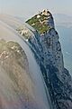
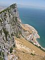
On its north side, the Rock rises straight up from the sea to 411.5 m (1,350 ft). The highest point of the Rock is 426 m (1,398 ft) at O'Hara's Battery, near the south end. The middle peak, Signal Hill, is 387 m (1,270 ft) high. This is also where the top station of the Gibraltar Cable Car is located.
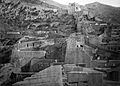
The eastern side of the Rock has steep cliffs that lead down to sandy slopes. These slopes were formed during past glaciations when sea levels were lower. The western side, where the City of Gibraltar is, is not as steep.
Calcite, a mineral in limestone, slowly dissolves in rainwater. This process creates caves over time. That's why the Rock of Gibraltar has more than 100 caves! St. Michael's Cave, halfway up the western slope, is the most famous and a popular place for tourists.
Scientists have also found Neanderthal fossils in several spots on the Rock. In 1848, a Neanderthal woman's skull was discovered at Forbes' Quarry. Later, excavations in Gorham's Cave showed that Neanderthals lived there. Plant and animal remains in the cave proved that Neanderthals had a very varied diet.
Fortifications: Protecting the Rock

The Rock of Gibraltar has been a very important military spot for centuries.
Moorish Castle
The Moorish Castle is an old building from when the Moors ruled Gibraltar for 710 years. It was built in 711 A.D., when the Berber leader Tariq ibn-Ziyad first landed on the Rock. A historian from the 1600s wrote that Tariq burned his ships after landing.
The main part of the castle still standing is the Tower of Homage. It's a huge building made of brick and a very strong concrete called tapia. The upper part of the tower had living areas and a Moorish bath for its past residents.

Underground Tunnels: The Galleries
A special feature of the Rock is its system of underground passages, known as the Galleries or the Great Siege Tunnels.
The first tunnels were dug during the Great Siege of Gibraltar, which lasted from 1779 to 1783. General Elliot, who led the soldiers during the siege, wanted to fire cannons at the Spanish from the side of the Rock. A sergeant suggested digging a tunnel. At first, they just needed an opening for air, but once it was made, they put a gun there! By the end of the siege, the British had built six openings and placed four guns.
The Galleries that tourists can visit today were built later, finished in 1797. They are a huge system of halls and passages, almost 304 m (997 ft) long. From these tunnels, you can see amazing views of the Bay of Gibraltar, the narrow strip of land connecting it to Spain, and Spain itself.
World War II and Beyond
When World War II started in 1939, the people living in Gibraltar were moved to places like Morocco and the United Kingdom. This was so the military could make Gibraltar stronger against a possible German attack. By 1942, there were over 30,000 British soldiers, sailors, and airmen on the Rock. They made the tunnel system even bigger. The Rock became a key place for protecting shipping routes in the Mediterranean Sea.
In 1997, it was revealed that the British had a secret plan called Operation Tracer. The plan was to hide soldiers in tunnels under the Rock if the Germans captured it. This team would use radio equipment to report enemy movements. A six-person team waited in Gibraltar for two and a half years. But the Germans never got close to capturing the Rock, so the men were never sealed inside. The team went back to their normal lives when the war ended.
Famous Sayings

The saying "solid as the Rock of Gibraltar" means something is very safe or strong.
The motto of the Royal Gibraltar Regiment and Gibraltar itself is Nulli Expugnabilis Hosti. This is Latin for "No Enemy Shall Expel Us."
Nature Reserve: Home to Wildlife

About 40% of Gibraltar's land area became a nature reserve in 1993. This means its plants and animals are protected by law.
Flora and Fauna: Plants and Animals
The Rock of Gibraltar is home to many interesting plants and animals. The most famous are the Barbary macaques, also known as the Rock apes. There are also Barbary partridges and unique flowers like the Gibraltar candytuft.
The Barbary macaques might have come from North Africa, or they could be the last of populations that lived across Southern Europe millions of years ago. Some animals on the Rock have been brought back by the Alameda Wildlife Conservation Park.
Birds: A Stop for Migrators
The Rock of Gibraltar is at the top of the Strait. This makes it a very important spot for migrating birds. Many birds stop here to rest and eat before continuing their long journeys over the sea and desert. In spring, they return to get ready for their trips to Western Europe, sometimes flying as far as Greenland or Russia.
BirdLife International has named the Rock an Important Bird Area. This is because an estimated 250,000 raptors (birds that hunt) fly across the Strait each year, making it a "bottleneck" where many birds gather. The Rock also supports populations of Barbary partridges and lesser kestrels that live and breed there.
Images for kids
-
Western face of the Rock of Gibraltar, in April 2006
-
Location of the Rock of Gibraltar's summit
-
A Levant cloud forming against the eastern cliffs of the Rock of Gibraltar
-
The sheer east side of the Rock of Gibraltar
-
The Moorish Castle
-
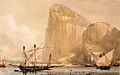
The Rock of Gibraltar's North Front cliff face from Bayside (c.1810) showing the embrasures in the Rock
-
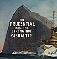
1909 insurance advertisement
-
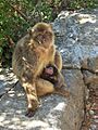
A female Barbary macaque feeding her young at Mediterranean Steps, on the Rock of Gibraltar
See also
 In Spanish: Peñón de Gibraltar para niños
