Sanilac Petroglyphs Historic State Park facts for kids
Quick facts for kids Sanilac Petroglyphs Historic State Park |
|
|---|---|
| ezhibiigadek asin | |
|
IUCN Category III (Natural Monument)
|
|

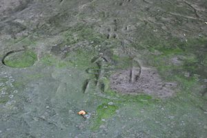
Detail of a carved archer-like carving at the site
|
|
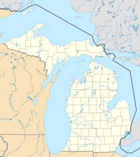
| Location | The Thumb, Sanilac County, Michigan, United States |
| Nearest town | Cass City, Michigan |
| Area | 240 acres (97 ha) |
| Elevation | 751 feet (229 m) |
| Designation | Michigan state park |
| Established | 1971 |
| Visitors | 4,300 (in 2015) |
| Administrator | Michigan Department of Natural Resources / Saginaw Chippewa Nation |
| Website | Sanilac Petroglyphs Historic State Park |
|
Sanilac Petroglyphs
|
|
| NRHP reference No. | 71001024 |
| Added to NRHP | January 25, 1971 |
The Sanilac Petroglyphs Historic State Park is a special place in Michigan. It is also known as ezhibiigadek asin, which means "written on stone" in the Ojibwe language. This park covers about 240 acres in Sanilac County. It is home to the largest collection of ancient petroglyphs (rock carvings) made by Native American people in Michigan.
These amazing carvings were made long ago, before Christopher Columbus arrived in America. They show important beliefs and stories of the Native American tribes. The park also has a fun hiking trail that follows the nearby Cass River. This historic park is looked after by both the Michigan Department of Natural Resources and the Saginaw Chippewa Nation. It became a state park in 1971 and is listed on the National Register of Historic Places.
Contents
Discovering the Ancient Rock Art
The most important part of the park is a large sandstone rock that is about 1,000 square feet. On this rock, there are around 100 different petroglyphs. These are the most rock carvings found in one place in Michigan. Experts believe they were carved between 400 and 1,400 years ago.
People living in the area discovered these carvings after a huge forest fire in 1881. The fire burned away trees and plants, revealing the ancient rock.
What the Carvings Show
The petroglyphs tell stories about the spiritual and cultural knowledge of the Native American tribes who lived near the Great Lakes. Some carvings show swirls, lines, and handprints. Others show living beings with special meanings:
- Ebmodaakowet: This is the archer, a person with a bow and arrow. He shoots knowledge into the future.
- Migizi Inini: This is the Eagle Man. He looks to the east, where the new day begins. He flies over to make sure people are following their traditions.
- Mishibizhew: This is the water panther. This creature protects the waters of the Great Lakes.
Studying and Protecting the Carvings
Archaeologists, who study ancient cultures, have been looking at this site since the 1920s. They have found old stone tools and pottery in the park. These finds show that different tribal groups have lived in this area for about 8,000 years.
In 1940, two researchers, Darrel J. Richards and Carl Holmquist, carefully recorded the petroglyphs. They made drawings and copies of the carvings. Richards' drawings are now kept at the Cranbrook Institute of Science in Michigan.
Efforts to Preserve the Site
After this, the Cranbrook Institute worked with the University of Michigan and the Michigan Department of Natural Resources. Together, they created the first plan to protect the site. In 1966, the Michigan Archaeological Society bought 240 acres around the petroglyphs. Five years later, they gave the land to the state. In 1971, the site officially became a Michigan state park and was added to the National Register of Historic Places.
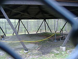
The state has made improvements to keep the rock safe. In the mid-1990s, a wooden shelter was built over the carvings. A fence was also put around the petroglyph area.
In 2018, experts used special technology called Lidar and detailed photos. They collected billions of data points to map the site very accurately. This showed details that are hard to see with just your eyes. These digital maps will help track any changes to the petroglyphs over time.
Challenges to Keeping the Carvings Safe
The sandstone rock where the petroglyphs are carved is delicate. It can be damaged by weather and other things in nature. Over the years, people have walked on it and even written graffiti on it. Long ago, someone even chipped out an entire symbol and the rock around it to keep as a souvenir.
In 2017, new carvings were made on the rock by unknown people. All this human activity, along with natural weathering, makes the original petroglyphs hard for visitors to see. There is worry that if more is not done to protect them, the carvings could disappear by the end of this century.
Nature and Wildlife at the Park
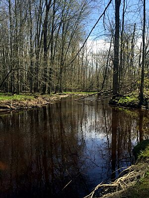
Beyond the rock carvings, you can explore the Cass River floodplain forest. There is a 1.5-mile hiking trail that loops through this area and crosses the river twice.
The park is home to many different animals. You might see deer, turkeys, ruffed grouse, green herons, and belted kingfishers. Along the trail, you can also see many outcrops of Marshall Sandstone. You can also find the spot where a 19th-century logging camp used to be. Signs along the trail explain interesting facts about the nature and history of the park.
Who Manages the Park?
On December 2, 2019, the Michigan Department of Natural Resources and the Saginaw Chippewa Nation signed an agreement. This agreement means they will work together to manage the park. This is a very important step, as it is the first time a Michigan state park has been managed jointly by the state and a Native American tribe.
The pavilion where the petroglyphs are located is usually open to visitors from May 28 through the summer. However, due to the COVID-19 pandemic, the pavilion remained closed into the summer of 2020.
 | May Edward Chinn |
 | Rebecca Cole |
 | Alexa Canady |
 | Dorothy Lavinia Brown |


