Santa Gertrudis Asistencia facts for kids

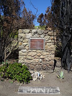
Santa Gertrudis Asistencia Monument, April 2018
|
|
| Location | Approximately five miles north of Mission San Buenaventura on the Camino Real |
|---|---|
| Coordinates | 34°20′51″N 119°17′49.5″W / 34.34750°N 119.297083°W |
| Patron | Gertrude the Great |
| Native tribe(s) Spanish name(s) |
Chumash |
The Santa Gertrudis Asistencia, also called the Santa Gertrudis Chapel, was like a small branch or "sub-mission" of the Mission San Buenaventura. It was part of the many Spanish missions built in California.
This small chapel was built sometime between 1792 and 1809. It was located about five miles from the main Mission San Buenaventura, further inland along the Ventura River. Sadly, the original site was covered up in 1968 when California State Route 33 (a highway) was built.
Before the highway construction, archaeologists dug up and studied the site. Some of the original foundation stones were moved. These stones were used to create the Santa Gertrudis Asistencia Monument. This monument was named a Ventura County Historic Landmark in 1970.
Contents
History of the Santa Gertrudis Asistencia
The Santa Gertrudis Asistencia was set up as a "sub-mission" for the Mission San Buenaventura. It served the Chumash people who lived in the Ventura River valley. This area was important for farming.
When Was It Built?
We don't know the exact date the asistencia was built. Historians believe it was created between 1792 and 1809. This was when the second church was being built at the main Mission. The asistencia was named after Gertrude the Great. She was a German nun, mystic, and writer from the 1200s.
Location Along El Camino Real
The asistencia was built along El Camino Real. This was a historic trail that connected all of California's Spanish missions. The Camino Real turned north from Mission San Buenaventura, following the Ventura River.
The Santa Gertrudis site was about 5.1 miles north of the Ventura River's mouth. It was also about 220 feet from the river's east bank. Some stories say it was near a sycamore tree. This tree was used by the Chumash people for their special ceremonies.
In 1926, a writer named Sol N. Sheridan described the spot. He said it was always a sacred place for the Native Americans. A large sycamore tree stood there. Under its branches, they would gather to worship their ancient god. Even in later times, they would hang feathers, cloth, and animal skins on its leaves as offerings.
A Safe Place During Troubles
During four difficult times for Mission San Buenaventura, the Mission padres (priests) sometimes moved to the Santa Gertrudis Asistencia.
- After a Fire: One possible move happened after a fire in the 1790s. This fire destroyed the first Mission church. Some accounts say a temporary mission, the Santa Gertrudis, was used until the main church was finished in 1809.
- After an Earthquake: Another move happened after the 1812 San Juan Capistrano earthquake. The padres moved inland for several months until the Mission was fixed. They built adobe buildings and huts during this time.
- Pirate Threat: A third move was in December 1818. This was because of a threat from Hippolyte Bouchard and his Peruvian pirate ships. The padres moved inland with the Mission's animals and valuable items. It's not completely clear if Santa Gertrudis was the exact spot, but some writings suggest it was considered a safe place.
- Another Earthquake: The fourth move happened after the 1857 Fort Tejon earthquake. Two historical accounts say the padres moved to Santa Gertrudis then.
In the mid-1880s, a farmer named Salmon R. Weldon plowed the land where the asistencia was. This covered up the remains of the chapel.
Archaeological Digs at the Site
In the 1960s, the state of California planned to build California State Route 33 over the area. This was believed to be the site of the Santa Gertrudis Asistencia. Before the highway was built, archaeologists were called in for an emergency dig.
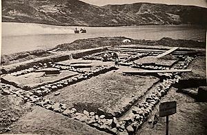
Archaeologists Roberta S. Greenwood and R. O. Browne led the excavation. They worked from March to April 1966. They had done some test digs before, but without much luck.
What Was Found?
During the 1966 dig, they found the exact spot of the asistencia. They used an old map from 1853. The dig uncovered the foundation of a building. It measured about 15.5 meters by 11.25 meters (about 50 by 37 feet). The foundation was made of large sandstone boulders. These were likely carried from the nearby Ventura River.
The building had four rooms. They were arranged in a U-shape around a sheltered courtyard. The largest room, Room 4, was likely used for worship. This was based on its size and where the main entrance seemed to be.
No walls were found standing, but an adobe brick was discovered. This led the archaeologists to believe the walls were made of adobe bricks.
They also found pieces of roof tiles. They thought that Emigdio Ortega might have taken the tiles. He reportedly bought roof tiles from the Mission padres after the 1857 earthquake. The tile pieces from Santa Gertrudis looked just like tiles at the Ortega Adobe. This suggested they came from the same place.
The archaeologists also found remains of two ovens or kilns behind the building.
After the dig, many people wanted the chapel to be moved and rebuilt. However, no plan was put in place before the highway construction. So, in January 1968, the remains of the chapel were moved. They were buried in a pit about 160 meters (about 525 feet) southeast of where the building originally stood.
Santa Gertrudis Asistencia Monument
In 1968, some of the chapel's original foundation stones were moved. They were used to create the Santa Gertrudis Asistencia Monument. This monument is about 500 feet south of the chapel's original spot. It's on the east side of North Ventura Avenue.
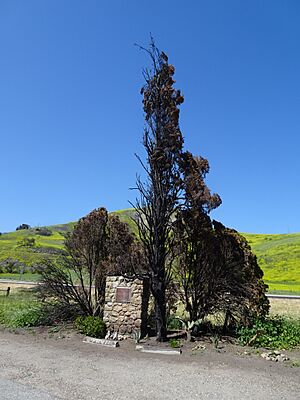
The monument was named Ventura County Historic Landmark No. 11 in December 1970. In December 2017, the Thomas Fire burned trees next to the monument. But the monument itself, being made of stone, was not harmed.
See also
 | Frances Mary Albrier |
 | Whitney Young |
 | Muhammad Ali |


