Sare facts for kids
Quick facts for kids
Sare
|
||
|---|---|---|
 |
||
|
||
| Country | France | |
| Region | Nouvelle-Aquitaine | |
| Department | Pyrénées-Atlantiques | |
| Arrondissement | Bayonne | |
| Canton | Espelette | |
| Intercommunality | Sud Pays Basque | |
| Area
1
|
51.34 km2 (19.82 sq mi) | |
| Population
(2006)
|
2,314 | |
| • Density | 45.072/km2 (116.74/sq mi) | |
| Time zone | UTC+01:00 (CET) | |
| • Summer (DST) | UTC+02:00 (CEST) | |
| INSEE/Postal code |
64504 /64310
|
|
| Elevation | 27–881 m (89–2,890 ft) (avg. 77 m or 253 ft) |
|
| 1 French Land Register data, which excludes lakes, ponds, glaciers > 1 km2 (0.386 sq mi or 247 acres) and river estuaries. | ||
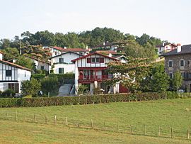
Sare is a charming village, also known as a commune, located in the southwestern part of France. It is part of the Pyrénées-Atlantiques département, which is like a county or region.
Sare is nestled in the western foothills of the Pyrenees mountains. It is about 15 kilometers (about 9 miles) east of Saint-Jean-de-Luz. This town is also close to the beautiful Atlantic Ocean.
Discovering Sare
Sare is a small but interesting place. It has a population of about 2,314 people, based on numbers from 2006. The village sits at an elevation of 77 meters (about 250 feet) above sea level. However, the land around it ranges from 27 meters to 881 meters high. This shows how close it is to the mountains!
What is a Commune?
In France, a commune is the smallest unit of local government. Think of it like a town or a village. Each commune has its own mayor and local council. They help manage things like schools, roads, and local services for the people living there.
Where is Sare Located?
Sare is in a special part of France called the Pyrénées-Atlantiques département. This area is known for its stunning landscapes. It has both mountains and a coastline. The Pyrenees mountains form a natural border between France and Spain. The Atlantic Ocean is also nearby, offering beautiful beaches and coastal towns.
 | John T. Biggers |
 | Thomas Blackshear |
 | Mark Bradford |
 | Beverly Buchanan |


