Saw Mill Run facts for kids
Quick facts for kids Saw Mill Run |
|
|---|---|

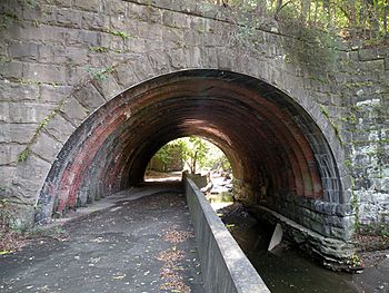
The Seldom Seen Arch, built in 1903, over Saw Mill Run along Saw Mill Run Boulevard not far from Woodruff Street in the Beechview neighborhood of Pittsburgh, Pennsylvania
|
|
| Physical characteristics | |
| Main source | Castle Shannon, Pennsylvania |
| River mouth | Ohio River |
| Length | 9.3 mi (15.0 km) |
| Basin features | |
| Basin size | 19 sq mi (49 km2) |
Saw Mill Run is a small river, also called a tributary, that flows into the Ohio River in Pennsylvania. It's an urban stream, meaning it flows through cities and towns. This stream is entirely within Allegheny County, Pennsylvania.
Saw Mill Run joins the Ohio River in Pittsburgh, near where the Allegheny and Monongahela rivers meet to form the Ohio. This spot was once a town called Temperanceville in the 1830s. The stream creates a path through the hilly area south of Pittsburgh, known as the South Hills. People have used this path for travel for a very long time.
The stream got its name from a real saw mill that used to operate near where it flows into the Ohio River. This mill was important during the building of Fort Pitt between 1759 and 1761. The mill provided a lot of the wood needed to build the new Fort after the British took control from the French.
Contents
How Transportation Grew Along Saw Mill Run
Saw Mill Run has been a key route for different types of transportation over the years. From early railroads to modern light rail, its path has helped connect communities.
Railroads and Their History
In the past, several railroads used the path along Saw Mill Run. These railways were important for moving coal and people.
Early Coal Railroads
The Coal Hill Coal Railroad was one of the first. It crossed Saw Mill Run on a bridge called a trestle and went upstream in 1861. Later, the Pittsburgh and Castle Shannon Railroad bought this line. They made it longer, following Saw Mill Run from the Pittsburgh and Castle Shannon Tunnel all the way to Castle Shannon, Pennsylvania. Another railway, the Little Saw Mill Run Railroad, followed a different branch of the stream towards Mt. Lebanon, Pennsylvania.
The Wheeling and Lake Erie Railway
The Wheeling and Lake Erie Railway (W&LE) also had a short rail line near the western end of the stream. This line was used by the Pittsburgh and West Virginia Railway to connect with another railroad. The W&LE used it until late 2008. Most of this railway line has since been removed.
Trolleys and Light Rail Today
The path of the Pittsburgh and Castle Shannon Railroad, except for the tunnel, was leased by Pittsburgh Railways in 1905. They later bought it in 1950. This railroad was special because it used a "dual gauge" system. This meant coal trains ran on a narrow track, often at night, while trolleys used a wider track. Today, this same path is part of the Pittsburgh Light Rail system. It follows Saw Mill Run from near the South Hills Junction (PAT station) to Castle Shannon, Pennsylvania.
Highways Parallel to the Stream
A part of Pennsylvania Route 51 runs right next to Saw Mill Run. This section of the highway is even named Saw Mill Run Boulevard, showing its close connection to the stream.
Understanding the Saw Mill Run Watershed
A watershed is an area of land where all the water drains into a single stream, river, or lake. The Saw Mill Run watershed is quite large.
Size and Location of the Watershed
The watershed of Saw Mill Run covers about 12,432 acres (50.31 km2), which is roughly 19 square miles (49 km2). The main stream itself is about 9.3 miles (15.0 km) long. It collects water from parts of several communities, including Bethel Park, Castle Shannon, Mount Oliver, and the city of Pittsburgh.

