
Scheduled monuments in Maidstone facts for kids
There are 27 amazing historic sites in Maidstone, Kent, England, that are called scheduled monuments. These are special places or buildings that are super important to the history of the United Kingdom. They get special protection from the government so they can't be changed without permission. Historic England, a group that looks after our heritage, helps decide which places get this protection.
Maidstone is a local area in Kent, covering about 152 square miles. It's mostly countryside, with the town of Maidstone in the northwest. About 166,400 people lived there in 2016. The scheduled monuments in Maidstone are from all different times, from a really old stone from the Stone Age to a tiny building from the 1700s that was once a mortuary. But most of them are from the Middle Ages.
Even though many of these sites are now just ruins or earthworks (shapes in the ground), Maidstone has the remains of four castles and five moated manor houses. A moat is a ditch, usually filled with water, that protected a building. There are also several buildings that used to be churches or parts of religious communities, like an abbey, a priory, and two tithe barns. A tithe barn was used to store a portion of crops given to the church. The buildings around the old College of All Saints and the Archbishop's Palace in Maidstone town centre are the best-preserved group of these monuments. Plus, seven medieval bridges over the River Medway and its smaller rivers are also protected.
What are Scheduled Monuments?
A scheduled monument is like a very old, important treasure. It's a place that tells us a lot about the past. These sites are protected by law to make sure they are not damaged or changed without permission. This helps us keep them safe for everyone to learn from and enjoy for many years to come.
Historic England is the main group that finds and lists these important places. They make sure that these ancient sites are looked after. Sometimes, a building can also be a "listed building," which is another way to protect it. But for very old archaeological sites, scheduled monument status is usually used.
Discovering Maidstone's Ancient Sites
Maidstone is full of history, from ancient stones to medieval castles and bridges. Let's explore some of these fascinating scheduled monuments:
| Name | What's Left | When it's From | Where it is | Map Link | What it is |
|---|---|---|---|---|---|
| White Horse Stone | Megalith (large stone) | Neolithic (Stone Age) | Aylesford | 51°18′54″N 0°30′53″E / 51.315003°N 0.514852°E | This is a huge standing stone, about 3 meters tall. People think it might have been part of an ancient burial chamber from the Stone Age, but there's no clear proof. It's a very old and mysterious landmark. |
| Moat at Coldbridge Farm | Earthworks (shapes in the ground) | 14th century | Boughton Malherbe | 51°11′46″N 0°41′41″E / 51.196066°N 0.694698°E 51°11′57″N 0°41′48″E / 51.199288°N 0.696589°E |
These are the remains of a medieval manor house called Coldbridge Castle. The house was taken down around the 1500s. You can still see parts of its two moats, which were ditches that protected the house. There's also an old paddock boundary and a fish pond. |
| Boughton Quarry camp | Earthworks | Iron Age | Boughton Monchelsea/ Loose |
51°14′10″N 0°31′42″E / 51.236099°N 0.528296°E | This is a U-shaped earthwork from before the Romans came to Britain. It covers about 28 acres and was probably a large settlement for the Belgae people, an ancient tribe. |
| Boxley Abbey | Standing buildings and buried remains | 1143 | Boxley | 51°18′01″N 0°31′30″E / 51.300385°N 0.525013°E | These are the remains of a Cistercian Abbey, which was a type of monastery. Most of it was taken down a long time ago. The Boxley Abbey Barn is the biggest part left. It's in poor condition and needs repair. |
| East Farleigh Bridge | Stone bridge | 14th century | East Farleigh | 51°15′16″N 0°29′05″E / 51.254437°N 0.484629°E | This is a medieval stone bridge with five arches that crosses the River Medway. It has strong, pointed parts called cutwaters on each side to help the water flow. It's a very old and important bridge. |
| East Sutton Manor | Earthworks | Medieval | East Sutton | 51°12′49″N 0°37′06″E / 51.213685°N 0.618313°E | This is a homestead moat, which means a moated area where a house once stood. It's in the grounds of East Sutton Park. The moat is partly filled with water and was likely the site of the old East Sutton manor house. |
| Sherway Bridge | Stone bridge | 17th century | Headcorn | 51°10′15″N 0°40′13″E / 51.170916°N 0.67014°E | This is a brick bridge built in the 1680s. It was rebuilt in 1846. |
| Ripple Manor | Earthworks | Medieval | Hollingbourne | 51°16′48″N 0°36′23″E / 51.279975°N 0.606394°E | This is the site of the medieval Ripple manor house. The moat and the island in its center are about 50 by 30 meters, and the moat is 7 to 15 meters wide. |
| Leeds Priory | Buried remains and standing buildings | 12th century | Leeds | 51°14′51″N 0°36′39″E / 51.247517°N 0.610777°E | These are the buried remains of an Augustinian priory (a type of monastery) founded in 1119. Later, a mansion was built on the same spot. A dovecote (a building for pigeons) and another building from the old priory still stand. The site needs repair to prevent collapse. |
| Lock-up or Mortuary | Standing building | Early 18th century | Lenham | 51°14′16″N 0°43′06″E / 51.237734°N 0.718466°E | This is a small stone building that was once used as a mortuary for the local workhouse. It was also used as a village jail. |
| College of All Saints | Standing buildings, ruins, and buried remains | 14th century | Maidstone | 51°16′11″N 0°31′18″E / 51.269687°N 0.521796°E | The buildings of this college were mostly built in the 1300s. They were made of rag-stone, a local type of stone. The remaining buildings were once the Master's house, the College Gateway, the dining hall, dorms, and the Master's Tower. There are also buried remains under modern buildings. |
| Gatehouse, Archbishop's Palace | Standing building | 13th to 14th century | Maidstone | 51°16′17″N 0°31′16″E / 51.271374°N 0.521142°E | This two-story building was built from rough stone and timber. It was an outbuilding for the Archbishop's Palace next door. Today, it's used as an office. |
| Len Bridge | Stone bridge | 14th century | Maidstone | 51°16′17″N 0°31′17″E / 51.271524°N 0.52128°E | This stone bridge crosses the River Len near where it meets the River Medway. It has two narrow arches designed for a watermill. A modern bridge is built above it, so you can only see the old bridge from the gardens of the Archbishop's Palace. |
| Tithe Barn | Standing building | 14th century | Maidstone | 51°16′17″N 0°31′20″E / 51.27128°N 0.522141°E | This large barn is made of rag-stone walls. It has a projecting two-story porch. The barn was used by the nearby Archbishop's Palace to store crops. |
| Earthworks in Milbay's Wood | Earthworks | Medieval | Nettlestead | 51°13′52″N 0°23′37″E / 51.231159°N 0.393729°E | These earthworks were once banks that held back water for a mill pond. People used to think they were part of an Iron Age hill fort, but now we know they were for a mill. |
| Moat at Lovehurst Manor | Earthworks | Medieval | Staplehurst | 51°08′38″N 0°32′27″E / 51.143811°N 0.540878°E | This is a homestead moat in the grounds of Lovehurst Manor. It's a circular moat, about 65 by 70 meters, and it's filled with water. It marks the spot of the original manor house. |
| Moot mound near Knox Bridge | Earthworks | Medieval | Staplehurst | 51°08′15″N 0°32′57″E / 51.137552°N 0.549097°E | These are the remains of a "moot," which was a meeting place, and a ditch around it. It was once thought to be a Norman castle mound. |
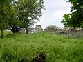
| Stockbury Castle | Earthworks | Norman | Stockbury | 51°19′25″N 0°38′54″E / 51.323726°N 0.648247°E | These are the remains of a "motte-and-bailey castle." A motte is a mound, and a bailey is a courtyard. The mound has been flattened, but parts of the ditch around the courtyard are still there. |
| Sutton Valence Castle | Ruins | 12th century | Sutton Valence | 51°12′44″N 0°35′53″E / 51.212313°N 0.597973°E | These are the ruins of a 12th-century square tower, called a keep. It's made of rag-stone and stands on an artificial mound. The remains are about 7 meters high, but the tower was probably much taller originally. |
| Teston Bridge | Stone bridge | 15th century | Teston | 51°15′11″N 0°26′51″E / 51.252983°N 0.447388°E | This is a medieval stone bridge over the River Medway. The middle three arches are from the 15th century or even earlier. The rest of the bridge was rebuilt in the 1800s. It has strong cutwaters on both sides. |
| Binbury Castle | Ruins and earthworks | Norman/ Medieval |
Thurnham | 51°18′44″N 0°35′53″E / 51.312206°N 0.598017°E | These are the remains of a motte-and-bailey castle. The ditch around the mound is still quite clear. Parts of a medieval manor house are also next to the castle site. This site is in poor condition and needs attention. |
| Corbier Hall | Buried remains | Late 14th century | Thurnham | 51°17′03″N 0°34′55″E / 51.284301°N 0.582057°E | This is believed to be the site of Corbier Hall. Foundations and a cellar were found in 1862, along with traces of a moat. Farming over the years has removed any signs on the surface, so now it can only be seen as a "crop mark" from above (different plant growth). |
| Thurnham Roman Villa | Buried remains | Roman | Thurnham | 51°17′08″N 0°34′36″E / 51.285535°N 0.576676°E | These are the remains of buildings connected to a Roman villa. The main part of the villa hasn't been found yet. Digs in the 1800s and 1900s found mosaic floors and stone walls. The site is now near the M20 motorway. |
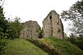
| Thurnham Castle | Ruins | Norman/ Medieval |
Thurnham | 51°17′38″N 0°35′30″E / 51.293983°N 0.591594°E | These are the ruins of a motte-and-bailey castle located on a hill. The courtyard area is about 55 by 35 meters. Parts of the flint walls are still standing, with the largest section about 22 meters long and 3.5 meters high. |
| Laddingford Bridge | Stone bridge | 14th century | Yalding | 51°12′49″N 0°25′10″E / 51.213742°N 0.419345°E | This is a medieval stone bridge over the River Teise with two pointed arches from the 14th century. The brick walls on the sides were added later. |
| Twyford Bridge | Stone bridge | 14th century | Yalding | 51°13′20″N 0°25′11″E / 51.222162°N 0.419686°E | This is a 40-yard long medieval stone bridge with four arches over the River Medway. It also has a raised path over the low ground next to the river. It has very large cutwaters on both sides. |
| Yalding Bridge | Stone bridge | 15th century | Yalding | 51°13′25″N 0°25′46″E / 51.223725°N 0.429322°E | This medieval stone bridge is 455 feet long and crosses the River Beult and the nearby flood plain with six arches. It is the longest medieval bridge in Kent. |
Images for kids
-
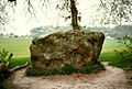
White Horse Stone is a megalith which possibly formed part of a neolithic burial chamber.
-
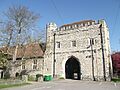
The College of All Saints (gateway shown), Maidstone contains a number of intact and ruined structures.
-
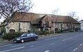
The Tithe Barn in Maidstone was constructed to serve the Archbishop's Palace.
-
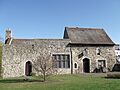
The Gatehouse to the Archbishop's Palace is in use today as an office building.
-
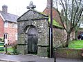
The Workhouse mortuary, Lenham, has also been used as the village gaol.
-
The remains of Sutton Valence Castle stand on an artificial mound.
-
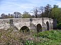
Teston Bridge, one of a number of medieval crossings over the River Medway and its tributaries that are scheduled monuments.
-
The ruins of Thurnham Castle on the North Downs


