Scottsville, Texas facts for kids
Quick facts for kids
Scottsville, Texas
|
|
|---|---|

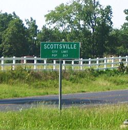
City limit sign at the intersection of US 80 and FM 2199
|
|

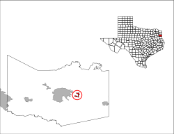
Location of Scottsville in Harrison County, Texas
|
|
| Country | United States |
| State | Texas |
| County | Harrison |
| Area | |
| • Total | 1.32 sq mi (3.41 km2) |
| • Land | 1.32 sq mi (3.41 km2) |
| • Water | 0.00 sq mi (0.00 km2) |
| Elevation | 371 ft (113 m) |
| Population
(2020)
|
|
| • Total | 334 |
| • Density | 253.0/sq mi (97.95/km2) |
| Time zone | UTC-6 (Central (CST)) |
| • Summer (DST) | UTC-5 (CDT) |
| ZIP code |
75688
|
| Area code(s) | 903, 430 |
| FIPS code | 48-66332 |
| GNIS feature ID | 2411846 |
Scottsville is a small city located in Harrison County, Texas, United States. In 2010, about 376 people lived there. By 2020, the population had changed to 334 people. It's a quiet place with a rich history.
Contents
History of Scottsville
Scottsville was first settled in June 1840 by William Thomas Scott and his family. He bought a lot of land and started five large cotton farms. One of these was Scottsville Plantation, where he lived.
Sadly, these farms were built and run by enslaved people. William Thomas Scott became the biggest slave owner in Harrison County. His home was even said to look like the mansion of Jefferson Davis in Mississippi.
On August 4, 1869, Scottsville got its own post office. In 1929, about 300 people lived in the community. A special marker was put up in 1936 to remember when Scottsville was founded and to celebrate 100 years of Texas Independence.
During the Great Depression, fewer people lived there, with the population dropping to just 50. But by the 1950s, it grew back to 260 people. The number of people living in Scottsville stayed pretty steady for the rest of the 1900s.
Geography and Location
Scottsville is found along Farm Roads 1998 and 2199. It's north of U.S. Highway 80 in the eastern part of Harrison County. The city is about 8 miles (13 km) east of Marshall, which is the main city of the county.
U.S. Highway 80 runs along the southern edge of Scottsville. It goes west to Marshall and east about 11 miles (18 km) to Waskom. Interstate 20 is about 3 miles (5 km) south of Scottsville. You can get to it from exit 624, which is Farm to Market Road 2199.
The United States Census Bureau says that Scottsville covers about 3.4 square kilometers (1.3 square miles) of land. There is no water area within the city limits.
Climate in Scottsville
The weather in Scottsville has hot and humid summers. Winters are usually mild to cool. This type of weather is called a humid subtropical climate. On climate maps, it's shown as "Cfa." This means it has warm temperatures and plenty of rain throughout the year.
Population and People
Scottsville has seen its population change over the years. Here's a quick look at how many people have lived there:
| Historical population | |||
|---|---|---|---|
| Census | Pop. | %± | |
| 1970 | 259 | — | |
| 1980 | 245 | −5.4% | |
| 1990 | 283 | 15.5% | |
| 2000 | 263 | −7.1% | |
| 2010 | 376 | 43.0% | |
| 2020 | 334 | −11.2% | |
| U.S. Decennial Census | |||
In 2010, Scottsville had 376 residents. The population was made up of different groups, including white, Black or African American, Native American, and Asian people. About 7.2% of the population was Hispanic or Latino.
By 2020, the population went down to 334 people. The city continues to be a mix of different backgrounds.
Education in Scottsville
Public schools in Scottsville are part of the Marshall Independent School District. Younger students attend David Crockett Elementary School, which teaches grades K-5. Older students go to Marshall Junior High School and Marshall High School.
For college, most students in Harrison County, including Scottsville, can attend Panola College. This is a community college that offers many different programs.
See also
 In Spanish: Scottsville (Texas) para niños

