Seal Islands (Aleutians East) facts for kids

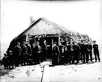
Russian Orthodox priest and members of his congregation, ca. 1905
|
|
| Geography | |
|---|---|
| Location | Bering Sea |
| Coordinates | 56°40′39″N 159°24′35″W / 56.67750°N 159.40972°W |
| Length | 7 mi (11 km) |
| Administration | |
| State | Alaska |
| Borough | Aleutians East |
| Additional information | |
| Time zone | |
| • Summer (DST) | |
| ZIP code | 99... |
| Area code | +1 907 |
The Seal Islands are a group of more than 12 islands located in the Bering Sea. These islands stretch about 7 miles (11 kilometers) towards the northeast. They are very close to the coast of Bristol Bay in Alaska. You can find them about 33 miles (53 kilometers) southwest of the Port Heiden Airfield.
Where the Name Comes From
The name "Seal Islands" has an interesting history. On old Russian maps, these islands were called "Ostrova Nerpichoi." This Russian name also means "Seal Islands."
A Russian naval officer and mapmaker named Mikhail Tebenkov gave them this name. He created detailed maps of the Northwest Coasts of America in 1852. The islands first appeared with the English name "Seal Islands" on a United States Bureau of Fisheries (USBF) map in 1888.
Black History Month on Kiddle
Outstanding African-Americans
 | Chris Smalls |
 | Fred Hampton |
 | Ralph Abernathy |

All content from Kiddle encyclopedia articles (including the article images and facts) can be freely used under Attribution-ShareAlike license, unless stated otherwise. Cite this article:
Seal Islands (Aleutians East) Facts for Kids. Kiddle Encyclopedia.

