Segundo, Colorado facts for kids
Quick facts for kids
Segundo, Colorado
|
|
|---|---|

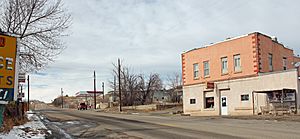
Colorado State Highway 12 as it passes through Segundo.
|
|

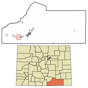
Location of the Segundo CDP in Las Animas County, Colorado.
|
|
| Country | |
| State | |
| County | Las Animas County |
| Founded | 1904 |
| Government | |
| • Type | unincorporated community |
| Area | |
| • Total | 0.694 sq mi (1.797 km2) |
| • Land | 0.694 sq mi (1.797 km2) |
| • Water | 0 sq mi (0.000 km2) |
| Elevation | 6,605 ft (2,013 m) |
| Population
(2020)
|
|
| • Total | 100 |
| • Density | 140/sq mi (56/km2) |
| Time zone | UTC-7 (MST) |
| • Summer (DST) | UTC-6 (MDT) |
| ZIP Code |
Trinidad 81082
|
| Area code(s) | 719 |
| GNIS feature ID | 2583292 |
Segundo is a small community in Las Animas County, Colorado, United States. It's called an unincorporated community because it doesn't have its own city government. It's also a census-designated place (CDP), which means the government counts its population for official records. In 2020, about 100 people lived in Segundo. The local post office in Trinidad handles mail for the area.
Contents
History of Segundo
How Segundo Was Founded
Segundo was started in 1904 by a company called Colorado Fuel and Iron (CF&I). It was built as a company town. This means the company owned most of the homes and businesses. The main goal was to house workers for a nearby coal mine.
What Does "Segundo" Mean?
The town's name, Segundo, comes from the Spanish word for "second." This is because it was the second mining community CF&I built. The first one was called Primero, which means "first."
Life in Early Segundo
CF&I tried to make Segundo a good place to live. They offered decent homes for the time. The company also helped people improve their lives. They sponsored a YMCA center, which is like a community center. There was also an elementary school for kids. Small businesses and a company store (a store owned by the company) were also part of the town.
Why Segundo Changed
Segundo was a busy town until the 1920s. Then, its population started to shrink. People faced health problems because of air pollution from the mines. Many homes also lacked indoor plumbing, which was becoming common in other places.
Demand for metallurgical coke (a type of fuel used in making steel) also went down. This meant workers lost their jobs. After a big fire in 1929, CF&I stopped its operations in Segundo. The town's population dropped so much that it almost became a ghost town.
Geography of Segundo
Where is Segundo Located?
Segundo is located about 14 miles (23 km) west of Trinidad. You can find it along Colorado State Highway 12. The town sits in the valley of the Purgatoire River.
Size of the Community
The area officially known as the Segundo CDP covers about 1.797 square kilometers (or 444 acres). All of this area is land.
Population of Segundo
How Many People Live Here?
The United States Census Bureau keeps track of the population in places like Segundo. They first defined Segundo as a CDP for the United States Census 2010.
Here's how the population has changed:
- 2010: 98 people
- 2020: 100 people
See also
 In Spanish: Segundo (Colorado) para niños


