
Seitz Canyon facts for kids
Quick facts for kids Seitz Canyon |
|
|---|---|

Seitz Canyon, looking southeast
|
|

Seitz Canyon
Location in Nevada
|
|
| Length | 5.5 mi (8.9 km) |
| Geography | |
| Location | Elko County, Nevada, United States |
Seitz Canyon is a beautiful and important canyon located in the Ruby Mountains of Elko County, in the northeastern part of Nevada, United States. It stretches for about 5.5 miles (8.8 kilometers).
This canyon was shaped a long time ago by huge sheets of ice called glaciers. These glaciers moved through the area during past ice ages. Seitz Canyon is a wild and scenic place. It is protected as part of the Ruby Mountains Wilderness Area and the Seitz-Echo Research Natural Area.
Contents
How Seitz Canyon Was Formed
Seitz Canyon shows amazing signs of how glaciers carved out the land. It has a special U-shape, which is typical for valleys created by glaciers.
The Canyon's Main Branch
The main part of Seitz Canyon starts high up at the top of Mount Silliman. This mountain is about 11,250 feet (3,429 meters) tall. Nearby are other tall peaks like Mount Gilbert and another unnamed peak.
From these high points, the canyon drops sharply for over 2,000 feet (610 meters). This steep drop is called a "headwall." It leads down to a flatter area that holds Seitz Lake.
Around Seitz Lake, you can see the clearest evidence of glaciers. Many bare granite rocks still have dark marks and scratches. These "striations" were made when the glaciers scraped across the rock.
Middle and Lower Sections
From Seitz Lake, the canyon gently slopes down to its middle part, which is about 8,000 feet (2,438 meters) high. Here, you'll find many aspen trees and ponds created by beavers.
The canyon then drops further to its lower section, around 7,000 feet (2,134 meters). This area has open forests of aspen and white fir trees, along with flat areas covered in sagebrush. Huge granite cliffs and tall, pointed rocks called "pinnacles" rise about 1,500 feet (457 meters) above.
The South Branch
Like its neighbor, Lamoille Canyon, Seitz Canyon has more than one branch. The southern branch starts at the highest point of the mountain range, the north face of Ruby Dome. Ruby Dome is about 11,387 feet (3,471 meters) tall. Two other peaks, Ruby Pyramid and Seitz Peak, are also nearby.
This southern branch drops steeply in four steps before joining the main part of Seitz Canyon.
A Unique Valley Merger
Scientists believe the southern branch of Seitz Canyon might have once flowed into a smaller valley called Thompson Creek. However, early glaciers were powerful enough to break through the ridge between the two canyons. This allowed the ice to flow into the deeper main branch of Seitz Canyon.
Because of this, Thompson Creek is now a "hanging valley." This means its source is perched high up, about 1,200 feet (366 meters), on the wall of Seitz Canyon. This merger also left a large area of exposed granite at the bottom of Seitz Canyon. The stream here forms a steep waterfall almost 1,000 feet (305 meters) long.
Rabbit Creek and Moraines
When the two branches of Seitz Canyon meet, they form Rabbit Creek. This creek flows into Pleasant Valley and then winds across Lamoille Valley. Finally, it joins the Humboldt River near the town of Halleck.
As Rabbit Creek leaves the mountains, you can see another interesting feature of Seitz Canyon: "lateral moraines." These are the best examples of moraines in the Ruby Mountains. Moraines are ridges of rocks and dirt that glaciers left behind as they moved. These ridges show the path the glaciers took and have smaller ridges that formed as the glaciers slowly melted away at the end of the last ice age.
Naming the Canyon
Seitz Canyon, and the lake within it, were named after two brothers, George and Edward Seitz. They were early ranchers in Pleasant Valley. George eventually moved away, but Ed Seitz became the sheriff of Elko County in 1869.
Gallery
-
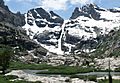
The headwall of Seitz Canyon, and Seitz Lake, looking south
-
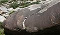
Glacial striations, patina, and sculptured granite near Seitz Lake
-
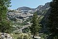
Ruby Dome, looking up the south fork of Seitz Canyon
-
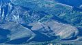
Lateral moraines at the mouth of Seitz Canyon


