Sergent Lake facts for kids
Quick facts for kids Sergent Lake |
|
|---|---|

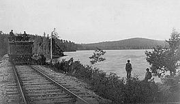
View of lake Sergent, circa 1888
|
|
| Location | Lac-Sergent (TNO), Portneuf Regional County Municipality, Capitale-Nationale, Quebec |
| Coordinates | 46°52′33″N 71°42′56″W / 46.8758°N 71.7155°W |
| Lake type | Lake of dam |
| Primary inflows | Several riparian streams |
| Primary outflows | Discharge of Lake Sergent |
| Basin countries | Canada |
| Max. length | 2.8 km (1.7 mi) |
| Max. width | 1.1 km (0.68 mi) |
| Max. depth | 37 m (121 ft) |
| Surface elevation | 154 m (505 ft) |
| Islands | 1 |
Lake Sergent is a freshwater lake located in the town of Lac-Sergent, Quebec, Canada. It's a popular spot for vacations, with many homes and cottages built along its shores. People started coming here for holidays around 1896.
Contents
Exploring Lake Sergent's Location
Lake Sergent is found north of the Saint-Laurent River. It sits between the towns of Saint-Raymond and Sainte-Catherine-de-la-Jacques-Cartier. It's the smallest of three big lakes in the area that are popular for vacations. The other two are Saint-Joseph Lake and Sept-Îles Lake.
Mountains and Water Flow
Mountains and forests surround Lake Sergent. To the southeast, a mountain reaches 330 meters high. Other peaks around the lake range from 270 to 372 meters. The lake gets its water from several small streams that flow down from these mountains. Lake Sergent is usually frozen from November to April each year.
The water flows out of Lake Sergent from its southern end. This outflow travels southwest for about 4.5 kilometers in a straight line. However, if you follow the winding path of the water, it's about 8.4 kilometers. This water eventually joins the Portneuf River.
Getting Around Lake Sergent
A railway line, once called the Transcontinental, passes by the south side of the village of Lac-Sergent. This railway helped the area grow a lot in the 1800s. Today, Route 367 goes around the northern part of the lake. A road called "chemin du Tour-du-Lac" circles the rest of the lake.
The Name of Lake Sergent
The name "Lac Sergent" was used even before 1829. A surveyor named Jean-Pierre Proulx mentioned it in his report that year. Historian Eugène Rouillard believes the name came about in the early 1800s. It might honor an old soldier who lived by the lake.
The name "Lac Sergent" was officially recognized on December 5, 1968. This was done by the Commission de toponymie du Québec, which is in charge of place names in Quebec.
Related Places to Discover
- Lac-Sergent, the town right next to the lake
- Portneuf Regional County Municipality
- Portneuf River
- Duchesnay tourist resort
 | Calvin Brent |
 | Walter T. Bailey |
 | Martha Cassell Thompson |
 | Alberta Jeannette Cassell |


