Sevenoaks District facts for kids
Quick facts for kids
Sevenoaks
Sevenoaks District
|
|
|---|---|
|
Non-metropolitan district
|
|

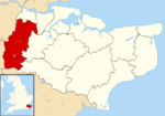
Sevenoaks shown within Kent
|
|
| Sovereign state | United Kingdom |
| Constituent country | England |
| Region | South East England |
| Non-metropolitan county | Kent |
| Status | Non-metropolitan district |
| Admin HQ | Sevenoaks |
| Incorporated | 1 April 1974 |
| Government | |
| • Type | Non-metropolitan district council |
| • Body | Sevenoaks District Council |
| Area | |
| • Total | 142.99 sq mi (370.34 km2) |
| Area rank | 112th (of 326) |
| Population
(2005 est.)
|
|
| • Total | 120,750 |
| • Rank | 193rd (of 326) |
| • Density | 844.47/sq mi (326.052/km2) |
| • Ethnicity | 95.2% White 1.5% S.Asians 1.2% Black 1.2% Mixed Race |
| Time zone | UTC0 (GMT) |
| • Summer (DST) | UTC+1 (BST) |
| ONS code | 29UK (ONS) E07000111 (GSS) |
Sevenoaks is a local government area in west Kent, England. It is called a non-metropolitan district. This means it is a type of local council that manages services for its area. The main office for the council is in the town of Sevenoaks.
The Sevenoaks District was created on 1 April 1974. It was formed by joining together the Sevenoaks Urban District, the Sevenoaks Rural District, and a small part of the Dartford Rural District. This change happened because of a law called the Local Government Act 1972.
Contents
What is the Sevenoaks District Like?
The land in Sevenoaks District is split between buildings and natural areas. About half of the district has buildings, roads, and other structures. The other half is made up of woodlands and farms.
Rivers and Waterways
The district includes the upper part of the River Darenth. It also has some of the starting points for the River Eden. These rivers are important natural features of the area.
The Metropolitan Green Belt
Most of the Sevenoaks District is part of the Metropolitan Green Belt. A Green Belt is a special area of land around a city. Its main purpose is to stop cities from growing too much. It also helps to keep green spaces for people to enjoy. This means there are strict rules about building new things in these areas.
Neighboring Areas
Sevenoaks District shares its borders with several other areas. To the north, it borders Dartford. To the northeast, it borders Gravesham. To the east, it borders Tonbridge and Malling. For a short distance to the southeast, it borders Tunbridge Wells.
It also borders two districts that are similar to it: Wealden in East Sussex to the south, and Tandridge in Surrey to the southwest. To the northwest, it borders two parts of London: the London Borough of Bromley and the London Borough of Bexley.
Population of Sevenoaks
In the year 2011, a count of all the people was done. This is called a census. The 2011 Census showed that the Sevenoaks District had a population of 114,893 people.
See also
 In Spanish: Distrito de Sevenoaks para niños
 | DeHart Hubbard |
 | Wilma Rudolph |
 | Jesse Owens |
 | Jackie Joyner-Kersee |
 | Major Taylor |


