Sgùrr a' Mhaoraich facts for kids
Quick facts for kids Sgùrr a' Mhaoraich |
|
|---|---|

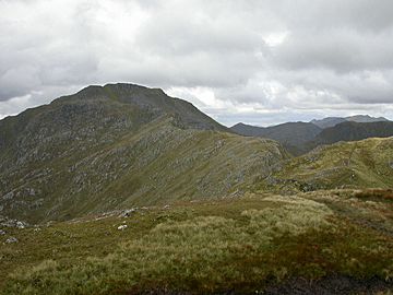
Sgùrr a' Mhaoraich's summit seen from Sgùrr Coire nan Eiricheallach
|
|
| Highest point | |
| Elevation | 1,027 m (3,369 ft) |
| Prominence | 706 m (2,316 ft) |
| Parent peak | Gleouraich |
| Listing | Munro, Marilyn |
| Naming | |
| English translation | peak of the shellfish |
| Language of name | Gaelic |
| Pronunciation | English approximation: SKOOR-ə-VOO-rish |
| Geography | |
| Location | Highland, Scotland |
| OS grid | NG983065 |
| Topo map | OS Landranger 33 |
| Climbing | |
| Easiest route | walk |
Sgùrr a' Mhaoraich is a tall mountain in Scotland. It is found in the northwest part of the Highlands, just north of Loch Quoich. This mountain stands 1027 meters (about 3,369 feet) high. Because of its height, it is known as a Munro.
When you look at Sgùrr a' Mhaoraich from the west or north, it looks very rocky and steep. It has many ridges and bowl-shaped valleys called corries. However, its southern side is much smoother and covered in grass, similar to nearby mountains like Gleouraich.
Contents
What Does the Name Sgùrr a' Mhaoraich Mean?
The mountain was first called Sgùrr a' Mhoraire. This name meant "peak of the landowner." Over time, its name changed on modern maps to Sgùrr a' Mhaoraich.
This new name might come from the Gaelic word maorach, which means "shellfish." Some people think the top of the mountain looks like a shell because it has ribbed shapes.
How Can You Climb Sgùrr a' Mhaoraich?
Most people who climb Sgùrr a' Mhaoraich start from the south. They begin near the shores of Loch Quoich.
The Main Route from Loch Quoich
- A special path, once used by deer stalkers, leads up a ridge called Bac nan Canaichean.
- This path takes you to a smaller peak named Sgùrr Coire nan Eiricheallach, which is 891 meters high.
- From there, a ridge about 1.5 kilometers long connects to the main summit of Sgùrr a' Mhaoraich.
- This ridge has some rocky parts. You can either climb over these rocks or find a way around them.
Another Way to Reach the Summit
- A less common way to climb the mountain is from the northeast end of Glen Quoich.
- This route also uses a stalker's path. It goes through a valley called Coire a' Carorainn.
- The path leads to a rocky peak named An Bathaich, which is 892 meters high.
- From An Bathaich, you head south to Sgùrr a' Mhaoraich. You will cross a high mountain pass, known as a bealach, to get there.
 | Isaac Myers |
 | D. Hamilton Jackson |
 | A. Philip Randolph |

