Shackleton, Western Australia facts for kids
Quick facts for kids ShackletonWestern Australia |
|
|---|---|

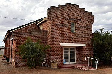
Shackleton Memorial Hall, 2018
|
|
| Established | 1951 |
| Postcode(s) | 6386 |
| Elevation | 249 m (817 ft) |
| Area | [convert: needs a number] |
| Location |
|
| LGA(s) | Shire of Bruce Rock |
| State electorate(s) | Central Wheatbelt |
| Federal Division(s) | O'Connor |
Shackleton is a small town in the Wheatbelt area of Western Australia. It is located near the Salt River. The town is also along a railway line that is no longer used. This line runs between Bruce Rock and Quairading. In 2016, 96 people lived in Shackleton.
About Shackleton
Shackleton started as a stop for the railway line in 1913. The town grew privately before it was officially recognized in 1951. It was named after Ernest Shackleton, a famous explorer who traveled to the Antarctic.
Important Buildings
The local Agricultural Hall was opened in 1920. It was built on land given by Dr. Germyn. This hall was an important meeting place for the community.
Shackleton was once home to what was called the "world's smallest bank." This was a branch of Bankwest. The building was tiny, measuring only 3 by 4 meters (about 10 by 13 feet). The bank closed its doors in 1997.
What the Town Produces
The land around Shackleton is used for farming. Farmers grow wheat and other cereal crops here. The town has a special site where these crops are collected. This site is run by Cooperative Bulk Handling, often called CBH. It helps farmers store and move their grain.
Sports in Shackleton
Shackleton used to have its own Australian rules football team. The team played from 1925 until 1970. After many years, the team stopped playing.
 | Emma Amos |
 | Edward Mitchell Bannister |
 | Larry D. Alexander |
 | Ernie Barnes |


