
Shakopee Historic District facts for kids
Quick facts for kids |
|
|
Shakopee Historic District
|
|

A mound and early brick building in Shakopee Historic District
|
|

Location in Minnesota

Location in the United States
|
|
| Location | 1801–2187 County Highway 101, Shakopee, Minnesota |
|---|---|
| Area | 76 acres (31 ha) |
| Built | 300 BCE–1875 |
| MPS | Scott County MRA (AD) |
| NRHP reference No. | 72000682 |
| Added to NRHP | April 11, 1972 |
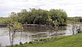
The Shakopee Historic District is a special area in Shakopee, Minnesota, United States. It is a place where important history happened. This district is located along the south bank of the Minnesota River.
It includes very old Native American living areas and burial sites. Some of these date back to before Europeans arrived. There was also a Dakota village here when Europeans first made contact. You can also find early European-American buildings and a place where people crossed the river by ferry.
This area was added to the National Register of Historic Places in 1972. It is important for understanding ancient history and how people lived long ago. It also shows us early buildings and how different cultures met.
The western part of the district is now Shakopee's Memorial Park. The eastern side is called The Landing. This is a living history village run by the Three Rivers Park District. Here, you can see how people lived in the past.
History of Shakopee
Native Americans used this land a very long time ago, starting around 300 BCE. Over many centuries, they built many large mounds here. These mounds were often used for burials or other important purposes.
By the late 1600s, the people living here were part of the Santee band of Eastern Dakota. Around the year 1800, a series of chiefs named Shakopee led the village. This Dakota village had bark lodges and cornfields. Early European explorers and settlers wrote about it. For example, Stephen Harriman Long visited in 1823 and described the village.
In 1839, a Native American person trained in European farming methods came to the village. This was to help introduce new ways of growing food. In 1844, Oliver Faribault moved to the area. He was the son of a trader named Jean-Baptiste Faribault. Oliver built the first European-style house in what became Scott County.
Two years later, Chief Shakopee II invited a Protestant missionary named Samuel W. Pond to live there. Pond came to open a school and a mission. In 1858, a group of Ojibwe warriors attacked the village. This event is known as the Battle of Shakopee. Samuel Pond's two sons later built a gristmill in 1875. This mill is still standing today.
The area began to be developed as an open-air museum in 1969. Oliver Faribault's old cabin was moved to the property. Four buildings from the farm of an early German immigrant family, the Bergers, were also moved there. Many other historical buildings and some copies have been added since then.
Images for kids
-

Prehistoric burial mounds
-
Site of Murphy's Landing
-
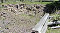
Ruins of Murphy's Inn
-
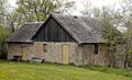
The Pond Gristmill


