Sharptown, Maryland facts for kids
Quick facts for kids
Sharptown, Maryland
|
|
|---|---|

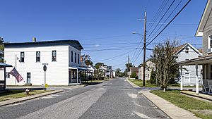
The center of Sharptown in 2020
|
|

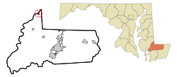
Location of Sharptown, Maryland
|
|
| Country | United States |
| State | Maryland |
| County | Wicomico |
| Incorporated | 1874 |
| Government | |
| • Type | Town commissioners |
| Area | |
| • Total | 0.42 sq mi (1.09 km2) |
| • Land | 0.42 sq mi (1.09 km2) |
| • Water | 0.00 sq mi (0.00 km2) |
| Elevation | 10 ft (3 m) |
| Population
(2020)
|
|
| • Total | 691 |
| • Density | 1,633.57/sq mi (631.33/km2) |
| Time zone | UTC-5 (Eastern (EST)) |
| • Summer (DST) | UTC-4 (EDT) |
| ZIP code |
21861
|
| Area code(s) | 410, 443 |
| FIPS code | 24-71650 |
| GNIS feature ID | 0591265 |
| Website | www.townofsharptown.org |
Sharptown is a small town located in Wicomico County, Maryland, in the United States. In 2010, about 651 people lived there. It is part of the larger Salisbury, Maryland-Delaware Metropolitan Statistical Area.
Contents
Sharptown's History
A special building called the San Domingo School was added to the National Register of Historic Places in 2007. This means it's an important historical place.
Sharptown's Location and Size
Sharptown is found at these coordinates: 38°32′26″N 75°43′8″W / 38.54056°N 75.71889°W.
The United States Census Bureau says the town covers about 0.46 square miles (1.19 square kilometers) in total. Most of this area, about 0.41 square miles (1.06 square kilometers), is land. The rest, about 0.05 square miles (0.13 square kilometers), is water.
Sharptown's Population
| Historical population | |||
|---|---|---|---|
| Census | Pop. | %± | |
| 1880 | 411 | — | |
| 1890 | 427 | 3.9% | |
| 1900 | 529 | 23.9% | |
| 1910 | 722 | 36.5% | |
| 1920 | 713 | −1.2% | |
| 1930 | 727 | 2.0% | |
| 1940 | 653 | −10.2% | |
| 1950 | 680 | 4.1% | |
| 1960 | 620 | −8.8% | |
| 1970 | 660 | 6.5% | |
| 1980 | 654 | −0.9% | |
| 1990 | 609 | −6.9% | |
| 2000 | 649 | 6.6% | |
| 2010 | 651 | 0.3% | |
| 2020 | 691 | 6.1% | |
| U.S. Decennial Census | |||
Population in 2010
In 2010, a census counted 651 people living in Sharptown. There were 251 households, and 176 of these were families. The town had about 1,588 people per square mile (613 people per square kilometer).
Most people in Sharptown were White (92.6%). There were also African American (5.1%) and Asian (0.5%) residents. About 1.8% of people were from two or more races. Hispanic or Latino people made up 2.2% of the population.
Households and Families
Out of the 251 households:
- 35.9% had children under 18 living with them.
- 52.2% were married couples living together.
- 11.6% had a female head of the household with no husband.
- 6.4% had a male head of the household with no wife.
- 29.9% were not families.
About 23.5% of all households were made up of single individuals. Also, 9.6% had someone living alone who was 65 years old or older. On average, each household had 2.59 people, and each family had 3.06 people.
Age of Residents
The average age in Sharptown in 2010 was 39.2 years old.
- 26.1% of residents were under 18.
- 6.7% were between 18 and 24.
- 25.7% were from 25 to 44.
- 26.8% were from 45 to 64.
- 14.7% were 65 years or older.
The town had slightly more females (53.6%) than males (46.4%).
Images for kids
See also
 In Spanish: Sharptown (Maryland) para niños
 | James Van Der Zee |
 | Alma Thomas |
 | Ellis Wilson |
 | Margaret Taylor-Burroughs |

