Shelly Island facts for kids

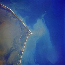
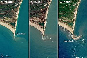
Shelly Island was a temporary island made of sand. It started to appear in April 2017. This sandy island formed as a sandbank in the Outer Banks of North Carolina. It was located near Cape Point in Buxton, North Carolina.
A big storm called Hurricane Maria made the island much smaller. At its biggest, Shelly Island was shaped like a crescent moon. It was about one mile (1.6 kilometers) long and over 500 feet (152 meters) wide. Local people called it Shelly Island because they found so many shells on its beaches. By early 2018, the island had completely disappeared.
Contents
How Shelly Island Formed and Changed
Shelly Island sat only a few hundred feet away from Hatteras Island. The water between them was not very deep, usually less than 5 feet (1.5 meters). The ocean area around this spot is sometimes called the Graveyard of the Atlantic. This is because many ships have sunk there over hundreds of years.
Small pieces of land often appear and then vanish in this area. But Shelly Island was special because it grew so large and so quickly. Scientists think it formed because there were not many strong winter storms called "nor'easters" that year. Also, there were more winds blowing from the southwest than usual. These conditions helped sand build up in one spot, creating the island.
The Island's Connection to Land
For a while, Shelly Island was separate from the mainland. This meant it was part of Dare County, North Carolina. If it had grown big enough to join with Hatteras Island, it might have become part of a national park, the Cape Hatteras National Seashore.
By September 18, 2017, Shelly Island was connected to the mainland when the tide was low. But when the tide was high, water still separated the island from the land. Over the next few weeks, the water channel between the island and the mainland started to get deeper again.
Hurricane Maria's Impact
In late September 2017, Hurricane Maria passed by. After the hurricane, experts in North Carolina thought that Shelly Island had shrunk by about 70%. The part of the island closest to the mainland joined up with it. Only a small, oval-shaped piece of land remained offshore.
Pictures taken from a satellite called Landsat 8 on February 16, 2018, showed that Shelly Island was completely gone. The rest of the island had merged with Cape Point, North Carolina.
Who Claimed Shelly Island?
A businessman named Ken Barlow from Mechanicsville, Virginia, said he owned Shelly Island. He tried to claim the island using a special legal document called a quitclaim deed. He filed this document in the Dare County office on August 7, 2017.
Mr. Barlow continued to say he owned the island even after it disappeared in early 2018. However, experts had warned that the island probably would not last a full year as a separate piece of land.
See also
 In Spanish: Shelly Island para niños


