Sheridan, Missouri facts for kids
Quick facts for kids
Sheridan, Missouri
|
|
|---|---|
 |
|

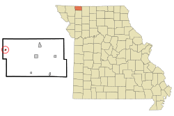
Location of Sheridan, Missouri
|
|
| Country | United States |
| State | Missouri |
| County | Worth |
| Area | |
| • Total | 0.19 sq mi (0.50 km2) |
| • Land | 0.19 sq mi (0.50 km2) |
| • Water | 0.00 sq mi (0.00 km2) |
| Elevation | 1,056 ft (322 m) |
| Population
(2020)
|
|
| • Total | 145 |
| • Density | 747.42/sq mi (288.13/km2) |
| Time zone | UTC-6 (Central (CST)) |
| • Summer (DST) | UTC-5 (CDT) |
| ZIP code |
64486
|
| Area code(s) | 660 |
| FIPS code | 29-67358 |
| GNIS feature ID | 2397656 |
Sheridan is a small city located in the northwest part of Worth County, Missouri, in the United States. It is situated close to the Platte River. In 2020, the city had a population of 145 people.
Contents
History of Sheridan
A post office in Sheridan started operating in 1887. The city was named after a local family who lived in the area.
Geography of Sheridan
Sheridan is found on Missouri Route 246. This road is just one mile east of the Worth County border. The city is also about 3.5 miles south of the state line between Missouri and Iowa. The Platte River flows nearby, about half a mile to the east.
According to the United States Census Bureau, Sheridan covers a total area of about 0.19 square miles (0.50 square kilometers). All of this area is land, with no water.
Population and People
| Historical population | |||
|---|---|---|---|
| Census | Pop. | %± | |
| 1900 | 347 | — | |
| 1910 | 409 | 17.9% | |
| 1920 | 418 | 2.2% | |
| 1930 | 341 | −18.4% | |
| 1940 | 377 | 10.6% | |
| 1950 | 370 | −1.9% | |
| 1960 | 277 | −25.1% | |
| 1970 | 251 | −9.4% | |
| 1980 | 220 | −12.4% | |
| 1990 | 174 | −20.9% | |
| 2000 | 185 | 6.3% | |
| 2010 | 195 | 5.4% | |
| 2020 | 145 | −25.6% | |
| U.S. Decennial Census | |||
Sheridan's Population in 2010
Based on the census from 2010, Sheridan had 195 residents. There were 98 households and 52 families living in the city. The city had about 1026 people per square mile. There were 141 homes, with about 742 homes per square mile.
Most of the people in Sheridan were White, making up 95.4% of the population. A small number were Asian (1.5%), and 1.0% were from other races. About 2.1% of residents identified with two or more races. People of Hispanic or Latino background made up 1.5% of the population.
Out of the 98 households, 20.4% had children under 18 living with them. Many households (45.9%) were married couples living together. A small number had a female head of household without a husband (3.1%). Even fewer had a male head of household without a wife (4.1%). Nearly half (46.9%) were non-family households. About 43.9% of all households had just one person living there. Also, 24.5% of households had someone aged 65 or older living alone. The average household had 1.99 people, and the average family had 2.81 people.
The average age of people in Sheridan was 47.2 years old. About 19.5% of residents were under 18. Around 8.8% were between 18 and 24 years old. About 18.4% were from 25 to 44. A larger group, 29.2%, were between 45 and 64 years old. Finally, 24.1% of the population was 65 years or older. The city's population was almost evenly split between genders, with 49.2% male and 50.8% female.
See also
 In Spanish: Sheridan (Misuri) para niños

