Sheridan, Indiana facts for kids
Quick facts for kids
Sheridan, Indiana
|
|
|---|---|

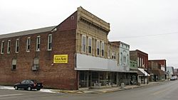
Main Street
|
|

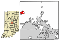
Location of Sheridan in Hamilton County, Indiana.
|
|
| Country | United States |
| State | Indiana |
| County | Hamilton |
| Township | Adams |
| Area | |
| • Total | 2.08 sq mi (5.37 km2) |
| • Land | 2.07 sq mi (5.36 km2) |
| • Water | 0.00 sq mi (0.01 km2) |
| Elevation | 948 ft (289 m) |
| Population
(2020)
|
|
| • Total | 3,106 |
| • Density | 1,499.76/sq mi (579.09/km2) |
| Time zone | UTC-5 (EST) |
| • Summer (DST) | UTC-5 (EST) |
| ZIP code |
46069
|
| Area code(s) | 317 |
| FIPS code | 18-69354 |
| GNIS feature ID | 2397655 |
| Website | www.sheridan.org |
Sheridan is a town located in Adams Township, Hamilton County, Indiana, United States. In 2010, the town had a population of 2,665 people. The very center of Indiana's population is found just northwest of Sheridan.
Contents
The Story of Sheridan's Past
Sheridan was once the second largest town in Hamilton County. It sits on land that used to belong to George Boxley. He was a merchant who had to leave Virginia because he was an abolitionist. This meant he was against slavery and helped enslaved people gain freedom.
How Sheridan Began as Millwood
The start of Sheridan, which was first called Millwood, is a bit unclear. Many town records were lost in a big fire in 1913. This fire destroyed the town hall and many other buildings.
A man named Egbert Higbee laid out a town called Millwood in 1866. It was next to a school on the state road. He started selling lots to merchants and mill owners. Soon, a small village began to grow.
Another person, Caswell Boxley, also created his own plat of Millwood. This was next to Higbee's land. Over time, the main street changed direction to run north and south.
From Millwood to Sheridan
In 1871, the village applied for a post office. However, there was already a town named Millwood in Indiana. So, this Millwood was renamed "Sheridan." It was named after a famous Civil War general, Philip Sheridan.
For a few years, people used both names, Millwood and Sheridan. But the new name eventually stuck. The town's location on the state road was perfect for an agricultural center.
Growth and Industry in Sheridan
Growth was slow until the Monon Railroad arrived in 1882. This brought a big boost to business and industry. Many important buildings from this time are still standing. One example is the H.J. Thistlethwaite Building, built in 1886. It had an opera house, meeting rooms, and shops.
Industries quickly grew along the railroad. The town of Sheridan officially became a town in 1886. In 1888, natural gas was discovered, which helped the town grow even more. Many new businesses moved to Sheridan because of this cheap fuel.
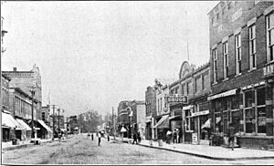
For a while, Sheridan had a glass factory, a cannery, and a large brickworks. Even after the natural gas supply ran out, many industries stayed. Around 1900, Sheridan was the second largest town in the county. Its main street was full of shops, hotels, and banks. Many of these old buildings are still there today.
The Great Fire of 1913
In 1913, a huge fire started in a lumber company. It destroyed much of the south end of downtown Sheridan. The old Town Hall also burned down. After the fire, a new brick building was built for the Town Hall.
Over the next 15 years, many houses on Main Street were replaced by new shops. New businesses opened, including several movie theaters. The American State Bank of Sheridan built its headquarters in 1914. The town's post office moved into a beautiful new building in 1940.
After World War II, more shopping areas developed outside downtown. But downtown Sheridan kept its historic feel. Many buildings from the 1880s to the 1930s are still standing. They show the town's exciting boom years.
Historic Places in Sheridan
Several places in Sheridan are listed on the National Register of Historic Places. These include the George Boxley Cabin, the Davenport-Bradfield House, and the Sheridan Downtown Commercial Historic District.
Sheridan's Location and Land
Sheridan covers about 2.14 square miles (5.54 square kilometers) of land. Only a tiny part, about 0.004 square miles (0.01 square kilometers), is water.
People Living in Sheridan
| Historical population | |||
|---|---|---|---|
| Census | Pop. | %± | |
| 1880 | 308 | — | |
| 1890 | 1,134 | 268.2% | |
| 1900 | 1,795 | 58.3% | |
| 1910 | 1,768 | −1.5% | |
| 1920 | 1,761 | −0.4% | |
| 1930 | 1,763 | 0.1% | |
| 1940 | 1,720 | −2.4% | |
| 1950 | 1,965 | 14.2% | |
| 1960 | 2,165 | 10.2% | |
| 1970 | 2,137 | −1.3% | |
| 1980 | 2,200 | 2.9% | |
| 1990 | 2,046 | −7.0% | |
| 2000 | 2,520 | 23.2% | |
| 2010 | 2,665 | 5.8% | |
| 2020 | 3,106 | 16.5% | |
| U.S. Decennial Census | |||
Population Details from 2010
In 2010, there were 2,665 people living in Sheridan. There were 1,013 households, which are groups of people living together. About 698 of these were families.
The town had about 1,245 people per square mile. Most of the people (95.3%) were White. About 3.3% of the population was Hispanic or Latino.
Many households (38.7%) had children under 18 living with them. The average age in Sheridan was 33.8 years old. About 29.3% of residents were under 18.
Amazing Sports History
Sheridan High School is famous for its successful football teams. They have won many Class 1A Indiana state championships. These wins happened in 1980, 1984, 1987, 1988, 1992, 1998, 2005, 2006, and 2007. Coach Larry "Bud" Wright led the teams to these victories. He is now in the Indiana Hall of Fame.
The Sheridan High School Blackhawk Marching Band has also done very well. They competed in ISSMA Class D competitions. The band reached the State Finals several times. In 1995, they won the ISSMA Class D State Championship!
The Sheridan High School Blackhawk Winter Guard also competed in IHSCGA events. They made it to State Finals in 1994, 1996, 1997, 2000, and 2001. In 1996, they won the third-place bronze medal at the State Finals.
Getting Around Sheridan
Sheridan is about 30 miles (48 kilometers) northwest of downtown Indianapolis. It is located where Indiana Highways 38 and 47 meet. The town used to have the Monon Railroad, but it is no longer in use. Sheridan has its own airport, the Sheridan Airport. The Indianapolis Executive Airport is also nearby.
Learning and Schools
Sheridan has several schools for students:
- Sheridan Elementary School (opened in 2010)
- Sheridan Middle School
- Sheridan High School
The town also has a place for reading and learning, the Sheridan Public Library.
Famous People from Sheridan
Some well-known people have connections to Sheridan:
- Mel Daniels: A former basketball star in the NBA and NCAA.
- David E. Kendall: A personal lawyer for Bill Clinton and Hillary Clinton. He was born and grew up in Sheridan.
- Brad Maynard: A former punter in the NFL (National Football League).
See also
 In Spanish: Sheridan (Indiana) para niños
 | Precious Adams |
 | Lauren Anderson |
 | Janet Collins |


