
Sherpur District facts for kids
Quick facts for kids
Sherpur
শেরপুর
|
|
|---|---|

Location of Sherpur District in Bangladesh
|
|
| Country | |
| Division | Mymensingh Division |
| Area | |
| • Total | 1,363.76 km2 (526.55 sq mi) |
| Population
(BBS census 2011)
|
|
| • Total | 1,542,610 |
| • Density | 1,131.145/km2 (2,929.652/sq mi) |
| Demonym(s) | Sherpuri |
| Time zone | UTC+06:00 (BST) |
| Postal code |
2100
|
Sherpur is a district in central Bangladesh. Think of a district as a large area or region within a country. Sherpur is part of the Mymensingh Division, which is like a bigger group of districts. It used to be a smaller part of the Jamalpur district.
Sherpur became its own district on February 22, 1984. This means it got its own local government and became more independent. The main city of Sherpur is about 198 kilometers (about 123 miles) north of Dhaka, which is the capital city of Bangladesh.
Images for kids
-
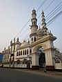
Mysaheba Jame Masque, Sherpur

See also
 In Spanish: Sherpur (zila) para niños

All content from Kiddle encyclopedia articles (including the article images and facts) can be freely used under Attribution-ShareAlike license, unless stated otherwise. Cite this article:
Sherpur District Facts for Kids. Kiddle Encyclopedia.