Stoneville, North Carolina facts for kids
Quick facts for kids
Stoneville, North Carolina
|
|
|---|---|
 |
|

Location of Stoneville, North Carolina
|
|
| Country | United States |
| State | North Carolina |
| County | Rockingham |
| Named for | Stone family |
| Area | |
| • Total | 1.43 sq mi (3.70 km2) |
| • Land | 1.43 sq mi (3.70 km2) |
| • Water | 0.00 sq mi (0.00 km2) |
| Elevation | 814 ft (248 m) |
| Population
(2020)
|
|
| • Total | 1,308 |
| • Density | 914.69/sq mi (353.15/km2) |
| Time zone | UTC-5 (Eastern (EST)) |
| • Summer (DST) | UTC-4 (EDT) |
| ZIP code |
27048
|
| Area code(s) | 336 |
| FIPS code | 37-65100 |
| GNIS feature ID | 2406669 |
| Website | Town Of Stoneville, NC |
Stoneville is a small town located in Rockingham County, North Carolina, in the United States. It's part of the larger Piedmont Triad area. In 2020, about 1,308 people lived there.
Contents
Discovering Stoneville's Past
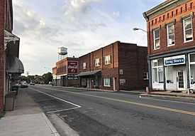
People first settled in this area, between the Mayo and Dan rivers, in the early 1800s. In 1827, a large farm called Deep Springs Plantation was built for James Madison Scales and his wife. This farm was located in what is now Stoneville.
Later, in 1843, the R.H. Lewis Tobacco company started up on the south side of the future town. In the late 1850s, two brothers, Thomas and Pinkney Stone, bought land here. The town was officially recognized on March 5, 1877, and was named after the Stone family.
Stoneville became an important trading center because it was a natural stop on the Norfolk-Western rail line. The town grew by trading tobacco, cotton, and products from grist-mills.
The 1998 Tornado Event
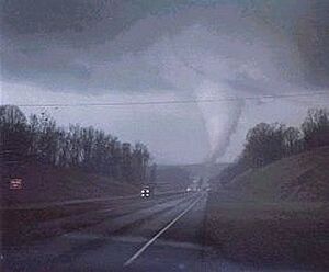
On March 20, 1998, Stoneville was hit by a very strong tornado, known as an F3 tornado. It caused a lot of damage to businesses in the main part of town along Henry Street. The railway station was also destroyed.
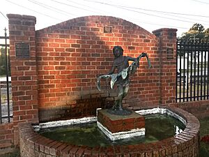
Sadly, two people lost their lives because of the tornado. One was an elementary school teacher and dancer named Beth Mitchell, who died in Stoneville. Another person, Powell Hickman, died southwest of the town. Many buildings in the downtown area were completely gone. Most of the cleanup and repairs were finished within a year. Later, the town built Friendship Park and painted a mural to remember those who were lost.
Stoneville's Location and Size
Stoneville is located in North Carolina and covers an area of about 1.43 square miles (3.70 square kilometers). All of this area is land.
Who Lives in Stoneville?
| Historical population | |||
|---|---|---|---|
| Census | Pop. | %± | |
| 1880 | 100 | — | |
| 1890 | 115 | 15.0% | |
| 1910 | 404 | — | |
| 1920 | 472 | 16.8% | |
| 1930 | 564 | 19.5% | |
| 1940 | 615 | 9.0% | |
| 1950 | 786 | 27.8% | |
| 1960 | 951 | 21.0% | |
| 1970 | 1,030 | 8.3% | |
| 1980 | 1,054 | 2.3% | |
| 1990 | 1,109 | 5.2% | |
| 2000 | 1,002 | −9.6% | |
| 2010 | 1,056 | 5.4% | |
| 2020 | 1,308 | 23.9% | |
| 2021 (est.) | 1,312 | 24.2% | |
| U.S. Decennial Census | |||
2020 Population Snapshot
| Group | Number | Percentage |
|---|---|---|
| White (not Hispanic) | 905 | 69.19% |
| Black or African American (not Hispanic) | 172 | 13.15% |
| Asian | 5 | 0.38% |
| Other/Mixed | 44 | 3.36% |
| Hispanic or Latino | 182 | 13.91% |
According to the 2020 census, Stoneville had 1,308 people living there. These people lived in 474 households, and 374 of these were families.
2010 Population Details
In 2010, there were 1,056 people living in Stoneville. There were 469 households, and 292 of these were families. About 20.7% of households had children under 18 living with them. The average household had 2.13 people.
The population was spread out by age. About 20% of the people were under 18 years old. The median age in Stoneville was 45 years.
Education in Stoneville
Students in Stoneville attend public schools that serve the area:
- Stoneville Elementary School
- West Rockingham Middle School (located in Madison)
- Dalton McMichael High School (located in Mayodan)
The town also has its own library branch, the Stoneville branch library, which is part of the Rockingham Public Library system.
Getting Around Stoneville
Air Travel
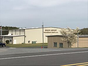
The Rockingham County NC Shiloh Airport is located just southeast of Stoneville. This airport is owned by the county and serves Stoneville, along with nearby towns like Madison, Eden, and Reidsville.
Roads and Highways
Stoneville's center is where Main Street (North Carolina Highway 770) and Henry Street meet. U.S. Route 220 goes around the west side of town. It connects Stoneville to Martinsville, Virginia to the north and Greensboro to the south. U.S. Route 311/North Carolina Highway 135 passes south of the town, between the main business area and the airport.
Train Lines
The Winston-Salem District of the Norfolk Southern Railroad runs north-south through Stoneville, dividing the town.
Historic Places to See
Stoneville is home to a couple of interesting historic sites:
- Deep Springs Plantation
- Mulberry Island Plantation
Famous People from Stoneville
Some notable people have connections to Stoneville:
- Tabitha Brown (born 1979) - an actress and social media personality.
- Beth Mitchell (1972-1998) - a competitive shag dancer.
- T. Clarence Stone (1899–1969) - a politician and businessman.
- William F. Stone (1909-1973) - a lawyer and politician.
- J.J. Webster (1898-1965) - a farmer, businessman, and politician.
- Jeff Webster (born 1966) - a checkers champion.
- John Ray Webster (born 1942) - another checkers champion.
- Mary Comer Webster (1928–2008) - known for her work in political strategy.
See also
 In Spanish: Stoneville para niños


