Shingle Springs, California facts for kids
Quick facts for kids
Shingle Springs
|
|
|---|---|

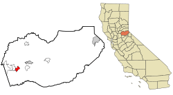
Location in El Dorado County and the state of California
|
|
| Country | |
| State | |
| County | El Dorado |
| Area | |
| • Total | 8.238 sq mi (21.335 km2) |
| • Land | 8.209 sq mi (21.260 km2) |
| • Water | 0.029 sq mi (0.075 km2) 0.35% |
| Elevation | 1,421 ft (433 m) |
| Population
(2020)
|
|
| • Total | 4,660 |
| • Density | 565.7/sq mi (218.42/km2) |
| Time zone | UTC-8 (Pacific (PST)) |
| • Summer (DST) | UTC-7 (PDT) |
| ZIP code |
95682
|
| Area code(s) | 530 |
| FIPS code | 06-71554 |
| GNIS feature ID | 1659645 |
| Reference #: | 456 |
Shingle Springs is a small community in El Dorado County, California. It is located in the Gold Country foothills. The town is about 40 miles (64 km) from Sacramento. It sits right on Highway 50. Nearby towns include Coloma and Placerville.
In 2010, the population of Shingle Springs was 4,432 people. The Shingle Springs Band of Miwok Indians, a Native American tribe, has its main office here.
Contents
History of Shingle Springs
Like many towns in California's Mother Lode, Shingle Springs started as a camp. Gold miners set up this camp during the California Gold Rush. These miners, called "49ers," followed the Carson-Emigrant Trail.
How Shingle Springs Got Its Name
The community got its name from a special machine. This machine made shingles (thin pieces of wood for roofs). It could make 16,000 shingles every day. The machine was near some springs at the edge of the camp. That's how "Shingle Springs" got its name.
Early Records and Post Office History
People who lived in Shingle Springs long ago kept good records. These records help us understand the Gold Rush better. For example, a group called the Boston-Newton Joint Stock Association camped here in 1849. They had traveled a long way across the country.
The town's post office has had a few name changes. It first opened as "Shingle Spring" in 1853. Then it closed in 1855. It reopened as "Shingle Springs" in 1865. In 1895, the name changed to "Shingle." Finally, in 1955, it went back to "Shingle Springs." Because of its history, Shingle Springs is now a California Historical Landmark (number 456).
Native American History in the Area
Before settlers from Europe and America arrived, a Maidu village was in this area. It was called Bamom. This village was located near where Shingle Springs is today.
Where is Shingle Springs?
Shingle Springs covers an area of about 8.2 square miles (21.3 square kilometers). Almost all of this area is land. In 2000, the area was a bit smaller, about 5.2 square miles (13.5 square kilometers).
People of Shingle Springs
In 2010, there were 4,432 people living in Shingle Springs. Most of the people were White (88.4%). There were also Native American (2.4%), Asian (1.1%), and African American (0.3%) residents. About 10.6% of the people were of Hispanic or Latino background.
Most people (98%) lived in homes with their families or housemates. The average household had about 2.67 people. The average age of people in Shingle Springs was 44.6 years old. About 23.3% of the population was under 18 years old.
Schools in Shingle Springs

Shingle Springs has several schools for students:
- Buckeye Elementary School
- California Montessori Project
- Pleasant Grove Middle School
- Ponderosa High School
- Latrobe Elementary School
- Miller's Hill Middle School
- Rescue Elementary School
Shingle Springs Climate
Shingle Springs has a "Mediterranean Climate." This means it has hot, dry summers and mild, wet winters.
See also
 In Spanish: Shingle Springs para niños
 | Percy Lavon Julian |
 | Katherine Johnson |
 | George Washington Carver |
 | Annie Easley |


