
Shoreline Park, Santa Barbara facts for kids
Quick facts for kids Shoreline Park |
|
|---|---|

Aerial view of Shoreline Park in the foreground
|
|
| Location | Shoreline Drive in Santa Barbara, California; Extending from La Marina to west of San Rafael Ave. |
| Area | 14.6 acres (6 ha) |
| Created | 1963-1967 |
| Designer | Richard B. Taylor |
| Operated by | City of Santa Barbara Parks & Recreation Department |
| Website | Shoreline Park |
Shoreline Park is a super popular park in Santa Barbara, California, USA. It's a long, thin strip of land right by the Pacific Ocean. This park sits on top of a mesa, which is like a flat-topped hill or coastal cliff.
Contents
Fun Things to Do at Shoreline Park

Shoreline Park has lots of cool stuff for everyone! You can find a fun playground and a nice picnic area for lunch.
It's also a great spot for whale watching. There's even a telescope and a big statue of a concrete whale tail to help you spot them!
The park also has a special Japanese garden. This garden celebrates Santa Barbara's "sister city" in Japan. A sister city is like a special friend city in another country.
On a clear day, you can see the Channel Islands far out in the ocean. If you visit during certain months, you might even see Gray Whales as they travel. Keep an eye out for other amazing sea animals too, like dolphins and seals!
Getting to the Beach
A special Torii gateway stands at the edge of the cliff. This traditional Japanese gate leads to a wooden staircase. The stairs go down about 53 feet (16 meters) to the beach below.
Be careful though! The beach is completely covered by water during high tide. You can only go down to the beach when the tide is low. When the tide is out, you can even walk to nearby Leadbetter Beach and Arroyo Burro Beach (also called Hendry's Beach).
How Shoreline Park Was Created

Before it was a park, the land where Shoreline Park now sits was used as farmland. This was back in the early 1900s. Later, in the 1950s, new roads and neighborhoods were built nearby. But the land that is now the park was left empty.
Saving the Land for a Park
In the early 1960s, some people wanted to build apartments on this beautiful ocean-front land. But a group of citizens had a different idea. They wanted to save the land so everyone could enjoy the amazing views and access to the coast.
In 1963, these citizens asked the city to buy the land and turn it into a park. The city council agreed! Then, a group called the "Save Our Shoreline Committee" asked voters to approve a plan to buy and develop the park. On August 4, 1964, the voters said "yes" to spending money for the park.

The city bought the land from its private owners in 1966. They also received extra money from the government to help with the costs.
Naming the Park
For a while, people just called it "The Shoreline Park." But in 1967, there was a contest to pick an official name! The judges chose "Shoreline Park," and the city council agreed on August 1, 1967. Even though some people have tried to change the name over the years, it has always stayed Shoreline Park.
A local landscape architect named Richard B. Taylor designed the park. Shoreline Park officially opened on December 14, 1968.
MacGillivray Point Lookout

In 1995, a special stone lookout point was built at the western end of the park. It's called MacGillivray Point. This spot was named after Don MacGillivray, who was the mayor of Santa Barbara when the park was being developed.
However, since 2008, MacGillivray Point has been fenced off. This is because there's a risk of a landslide, and the city wants to keep everyone safe. Experts have been watching the area to make sure it's stable.
Keeping the Park Safe from Erosion
Over the years, the edge of Shoreline Park has faced a lot of coastal erosion. This means the land near the ocean slowly wears away due to storms and natural ground movement.
In 2008, a landslide happened near the stairway leading to the beach after heavy rains. A part of the sidewalk above the cliff collapsed, making it dangerous. Because of this, the stairway and MacGillivray Point were fenced off.
The city started a project called the Shoreline Park Safety Improvement Project to fix these issues. By October 2012, they had completed the work. This included replacing sidewalks, adding new safety fences around MacGillivray Point, moving park benches, and updating signs and lights. These improvements help keep the park safe for everyone to enjoy!
Gallery
-
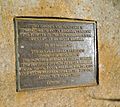
Commemoration plaque for the Torii gate leading to the beaches from the bluffs of Shoreline Park
-
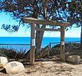
Torii gate along the bluff of Shoreline Park, 2015


