Sibinal facts for kids
Quick facts for kids
Sibinal
|
|
|---|---|
| County | |
| Department | |
| Climate | Cwb |
Sibinal is a town and area in the San Marcos Department of Guatemala. Its name comes from the Mam language. Tziben means "writing" and nal means "Bernard". So, Sibinal means "Bernard's writings".
This town was started in February 1799. It is in a mountainous area, about 2,500 meters (8,200 feet) high. Sibinal is very close to the border between Mexico and Guatemala. The village of Sibinal is also a starting point for people who want to climb Volcano Tacaná.
Contents
History of Sibinal
Early History: Spanish Colony Times

Long ago, in 1690, a nearby area called Tejutla was very large. It included many towns that are now separate, like Sibinal. According to old writings, Tejutla was a rich land with good weather and plenty of water.
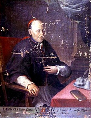
Tejutla was an important place for trade and religion. In 1767, it was described as the main trading center for all the towns around it. Later, in 1770, a bishop named Dr. Pedro Cortés y Larraz visited the area. He called Tejutla "Santiago at the top of the hill." He reported that 64 families lived there and were doing very well. Sibinal itself was officially founded as a settlement in February 1799.
After Guatemala Became Independent
After Guatemala became independent from Spain, the area changed. In 1821, Tejutla was first shown as part of what is now the San Marcos region.
By 1870, Tejutla had grown a lot. Its leaders even asked the government to make it a department capital. This new department would have included many towns, some of which are now in Mexico. Tejutla even had its own representatives in the government back then.
However, things changed when new leaders came to power. Generals Miguel Garcia Granados and Justo Rufino Barrios took control. They were liberals, and they made big changes. They removed some religious groups from Guatemala and stopped a rule that made people pay money to the church. This made Tejutla lose some of its main support. The new government also took land from religious groups and gave it to their friends. These friends then became big landowners in the area.
Climate in Sibinal
Sibinal has a temperate climate. This means it has mild temperatures, not too hot and not too cold.
| Climate data for Sibinal | |||||||||||||
|---|---|---|---|---|---|---|---|---|---|---|---|---|---|
| Month | Jan | Feb | Mar | Apr | May | Jun | Jul | Aug | Sep | Oct | Nov | Dec | Year |
| Mean daily maximum °C (°F) | 18.7 (65.7) |
19.0 (66.2) |
20.5 (68.9) |
21.0 (69.8) |
20.7 (69.3) |
19.7 (67.5) |
19.8 (67.6) |
20.2 (68.4) |
19.6 (67.3) |
19.1 (66.4) |
19.2 (66.6) |
18.9 (66.0) |
19.7 (67.5) |
| Daily mean °C (°F) | 11.3 (52.3) |
11.4 (52.5) |
12.9 (55.2) |
13.9 (57.0) |
14.8 (58.6) |
14.6 (58.3) |
14.6 (58.3) |
14.4 (57.9) |
14.4 (57.9) |
13.8 (56.8) |
12.8 (55.0) |
12.0 (53.6) |
13.4 (56.1) |
| Mean daily minimum °C (°F) | 3.9 (39.0) |
3.9 (39.0) |
5.3 (41.5) |
6.9 (44.4) |
8.9 (48.0) |
9.6 (49.3) |
9.4 (48.9) |
8.7 (47.7) |
9.3 (48.7) |
8.6 (47.5) |
6.4 (43.5) |
5.2 (41.4) |
7.2 (44.9) |
| Average precipitation mm (inches) | 6 (0.2) |
6 (0.2) |
26 (1.0) |
68 (2.7) |
187 (7.4) |
284 (11.2) |
211 (8.3) |
239 (9.4) |
276 (10.9) |
187 (7.4) |
26 (1.0) |
13 (0.5) |
1,529 (60.2) |
| Source: Climate-Data.org | |||||||||||||
Where is Sibinal Located?
Sibinal is about 75 kilometers (47 miles) west of San Marcos city. It is also 317 kilometers (197 miles) west of Guatemala City. Sibinal is surrounded by other towns in the San Marcos Department and shares a border with Mexico.
 |
Tacaná |  |
||
| Ixchiguán and Tajumulco | ||||
| Tajumulco |
See also
 In Spanish: Sibinal para niños
 | Kyle Baker |
 | Joseph Yoakum |
 | Laura Wheeler Waring |
 | Henry Ossawa Tanner |


