Sierra de Baza facts for kids
Quick facts for kids Sierra de Baza |
|
|---|---|

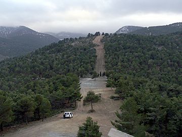
Firebreak in Sierra de Baza
|
|
| Highest point | |
| Peak | Calar de Santa Bárbara |
| Elevation | 2,269 m (7,444 ft) |
| Prominence | 850 |
| Geography | |
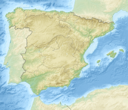
| Location | Granada province, Andalusia |
| Country | Spain |
| Parent range | Penibaetic System |
| Geology | |
| Mountain type | Limestone |
| Climbing | |
| Easiest route | From Baza |
The Sierra de Baza is a mountain range in Spain. It is located near the city of Baza in the Granada province. This mountain range gets its name from the nearby town of Baza.
The highest point in the Sierra de Baza is called Calar de Santa Bárbara. It stands tall at 2,269 meters (about 7,444 feet) above sea level. This area is known for its beautiful natural environment.
Contents
What is the Sierra de Baza?
The Sierra de Baza is a group of mountains. It is part of a larger system called the Penibaetic System. This system includes many important mountain ranges in southern Spain.
Where is the Sierra de Baza located?
This mountain range is found in the Andalusia region of Spain. It sits between other famous mountain ranges. To the west, you'll find the Sierra Nevada. To the north are the Sierra de Cazorla and Sierra de Segura.
As you go east, the Sierra de Baza connects with the Sierra de los Filabres mountains. This location makes it a key part of the region's geography.
Protecting the Sierra de Baza: A Natural Park
A special area has been created to protect the Sierra de Baza. It is called the Parque natural de la Sierra de Baza. This means it is a natural park.
Why is the natural park important?
Natural parks help keep the environment safe. They protect the plants, animals, and natural beauty of an area. The Parque natural de la Sierra de Baza works to preserve this unique mountain ecosystem.
Exploring the park: The GR 7 Footpath
If you like hiking, a long-distance trail goes through the natural park. It is called the GR 7. This path allows people to explore the park's landscapes. It is a great way to see the different parts of the Sierra de Baza.
See also
 In Spanish: Sierra de Baza para niños
 | Tommie Smith |
 | Simone Manuel |
 | Shani Davis |
 | Simone Biles |
 | Alice Coachman |


