Siksika 146 facts for kids
Quick facts for kids
Siksika 146
|
||
|---|---|---|
| Siksika Indian Reserve No. 146 | ||
|
||

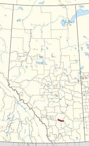
Location in Alberta
|
||
| First Nation | Siksika Nation | |
| Country | Canada | |
| Province | Alberta | |
| Municipal districts | Vulcan Wheatland |
|
| Headquarters | Gleichen | |
| Area | ||
| • Land | 701.96 km2 (271.03 sq mi) | |
| Population
(2021)
|
||
| • Total | 3,576 | |
| • Density | 4.96/km2 (12.8/sq mi) | |
Siksika 146 is a special area of land in southern Alberta, Canada. It is a First Nations reserve that belongs to the Siksika Nation. This land is about 87 kilometers (54 miles) southeast of Calgary. It sits at an elevation of about 857 meters (2,812 feet) above sea level.
Contents
Exploring Siksika 146
The main community called Siksika is located right on the Siksika 146 reserve. This reserve shares its borders with three different areas: Vulcan County, Wheatland County, and the County of Newell.
Historical Park on the Reserve
A very important place on the Siksika 146 reserve is the Blackfoot Crossing historical park. This park helps tell the story of the Siksika Nation and their history. It is a place where visitors can learn about the culture and traditions of the Siksika people.
People and Land Size
In 2021, a count of the population was done in Canada. This count showed that 3,576 people lived on the Siksika 146 reserve.
How Big is Siksika 146?
The Siksika 146 reserve covers a large area of land. It is about 696.54 square kilometers (268.94 square miles). This makes it the second-largest Indigenous reserve in all of Canada. Only the Blood 148, Alberta reserve is larger.
 | Claudette Colvin |
 | Myrlie Evers-Williams |
 | Alberta Odell Jones |


