
Silverhill, Nottinghamshire facts for kids
Quick facts for kids Silverhill |
|
|---|---|

Commemorative Statue Testing for Gas
|
|
| Highest point | |
| Elevation | 204.3 m (670 ft) |
| Prominence | 62 m (203 ft) |
| Geography | |

Silverhill
Location in Nottinghamshire
|
|
| Location | Nottinghamshire, England |
| OS grid | SK470621 |
Silverhill is a special hill located near Teversal in Nottinghamshire, England. It stands as one of the highest points in the county, reaching about 204.3 meters (670 feet) tall.
What makes Silverhill unique is that it's not a natural hill. It was created from the leftover rock and dirt from the old Silverhill coal mine, which closed down in the 1990s. In 2005, the area was transformed by the local council. They planted many trees, created walking paths, and added a fantastic viewpoint.
Now known as Silverhill Woods, it's a popular spot for outdoor activities. It's also part of a network of recreation sites. These areas are connected by paths that used to be old railway lines, once used to transport coal from the mines.
Contents
Amazing Views from Silverhill
From the very top of Silverhill, you can enjoy amazing views. On a clear day, you can see across five different counties! You might even spot famous landmarks like Lincoln Cathedral and Bolsover Castle.
The viewpoint also looks down on the historic Elizabethan Hardwick Hall. You can also see the busy M1 motorway from this high spot. The flat area at the top has stone blocks marking the main compass directions.
The Miner's Statue
A special bronze statue was added to the viewpoint later. It shows a kneeling coal miner holding a Davy lamp, which miners used to carry underground. This sculpture is called Testing for Gas.
It was created by an artist named Antony Dufort. The statue is a tribute to all the brave miners who worked in the Nottinghamshire coalfields. The base of the statue lists the names of 85 main coal mines in the county that operated between 1819 and 2005.
Finding Nottinghamshire's Highest Point
Silverhill was designed to be the highest point in Nottinghamshire. To make sure it was the tallest, an extra five meters (about 16 feet) of height were added during the landscaping work that finished in 2005. At first, it was thought to be 205 meters (673 feet) high.
However, some people thought other places might be taller. Two other spots were suggested: Strawberry Bank near Huthwaite and Newtonwood Lane on the western edge of the county.
The Official Survey
To find out for sure, a special survey was done in 2010. They used two methods: optical levelling and GPS. This helped them measure the exact height of all three locations.
The survey found that Strawberry Bank was about 202 meters (663 feet) high. Silverhill was measured at 204.3 meters (670 feet). The results showed that Newtonwood Lane was actually the highest point in the county, at 205 meters (673 feet).
Strawberry Bank has its own plaque and viewpoint, proudly stating it's the highest natural point. Newtonwood Lane, though unmarked and located near a water reservoir, is also considered a natural high point. It is now officially recognized as the county top for Nottinghamshire.
Images for kids
-
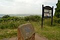
Viewpoint and plaque at Strawberry Bank SK462597
-
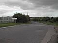
Newtonwood Lane, near Whiteborough SK456606


