Sinks of Gandy facts for kids
Quick facts for kids Sinks of Gandy |
|
|---|---|

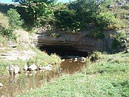
Sinks of Gandy Creek, Upper (upstream) entrance
|
|
| Location | Osceola, West Virginia, U.S. |
| Length | 8,114 feet (2,473 m) |
| Discovery | Before 1830s |
| Geology | Greenbrier Limestone |
| Entrances | 3 |
| Access | Private land; Access generally uncontrolled |
The Sinks of Gandy is a cool cave in Osceola, West Virginia, also known as the Sinks of Gandy Creek or just "The Sinks". It's a special place where a stream called Gandy Creek flows underground! You can find it in eastern Randolph County, West Virginia, right next to the Monongahela National Forest. Even though it's a well-known spot, the Sinks are on private land.
Contents
What is the Sinks of Gandy?
The Sinks of Gandy is like a natural tunnel. Gandy Creek, a small river that flows into Dry Fork, goes underground for about 3,000 feet (915 meters). It passes beneath a hill called Yokum Knob and then comes out on the other side.
The entrance to the Sinks on the upstream (southern) side is about 30 feet (9 meters) wide and 15 feet (4.5 meters) high. It's in a low rock ledge in a big, open field. Inside, the main passage of the cave is mostly straight. It can be anywhere from 4 to 35 feet (1 to 10 meters) high. The passage is usually 40 to 60 feet (12 to 18 meters) wide, but in some spots, it can be as wide as 100 feet (30 meters)!
Sometimes, the creek fills the whole floor of the cave. Other times, it flows in a narrow channel. The exit on the downstream (northern) side is a bit tricky to find. The main stream comes out from under some large rocks, but there's also a drier way out about 100 feet (30 meters) to the east.
History of the Sinks
Gandy Creek, and the Sinks, got their name from Uriah Gandy. He was one of the first settlers in this area, arriving around 1781. People living nearby definitely knew about the Sinks by the 1830s.
One of the earliest written mentions of the Sinks might be from a letter in November 1833. A doctor named Benjamin Dolbeare from Randolph County wrote to a historical society. He described several local caves, including one that sounds like the Sinks: "Between, what is here called, the Aleghany and Rich Mountains, heads a branch of the dry fork a tributary of Cheat River, a ridge extends itself quiet across, from one mountain to the other, and this branc[h], after keeping its course about 3 miles runs under this ridge which [is] about ¾ of mile wide at its base, and very high."
The Sinks area was also known as the last place where elk were hunted in what is now Randolph County. This happened around 1830 and 1835.
The Sinks during the Civil War
In March 1864, during the American Civil War, a small event happened at the Sinks. Some soldiers from the Confederate army, led by General John D. Imboden, had been stopping supply wagons. They went into nearby Tucker County and took things from a store.
Union soldiers chased them and caught up the next day at the Sinks. A small fight happened, and some of the Confederate soldiers were captured. The items taken from the store were also found.
How the Sinks became famous
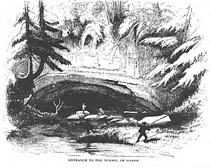
The Sinks first became widely known because of a funny story written by David Hunter Strother. It was published in Harper's Magazine in 1872 and 1873. The story was about a trip to the area that probably happened around 1854. It was called "The Mountains" and told about a group of "Virginia gentlemen" exploring the wild forest and looking for the "tunnel of Gandy."
Later, a writer from West Virginia named Jack Preble helped make the Sinks popular again. He wrote articles and booklets about the cave between the 1940s and 1960s. Around this time, the West Virginia Highway Department even started putting "The Sinks" on official roadmaps, hoping to attract tourists.
The Sinks was first officially mapped by cave explorers from the National Speleological Society on September 1, 1940. They found about 3,056 feet (931 meters) of passages. The cave was mapped again in 1990, and they found even more passages, adding 5,058 feet (1,542 meters). This means the total length of the Sinks is about 8,114 feet (2,473 meters)! As of 2014, this made it the 669th longest mapped cave in the U.S.
Visiting the Sinks
Both entrances to the Sinks are on private land. The upstream entrance is owned by the Teter family, and the downstream exit is owned by the Tingler family. There are no signs in the area pointing to the cave.
There is a parking lot for the Sinks on Dry Fork Road (County Route 40) at 38°42′55.8″N 79°38′15.7″W / 38.715500°N 79.637694°W. A trail to the upstream entrance starts nearby.
The Sinks cave is fairly easy for new visitors to explore. Because it's mostly a straight passage, most people can go through it safely with just a regular flashlight. However, you will need to climb over some rocks and walk through water in certain parts. Many visitors have trouble finding the dry exit on the downstream side, which is about 200 feet (60 meters) back and to the right from where the stream comes out. If you can't find it, you'll have to go back the way you came!
More Information
- McGrew, Wes, Netherworld News, September 1959.
- Perry, Clay, "Come Let's Go Spelunking", Saturday Evening Post, pp. 14–15, 36, 38; 12 July 1941.
- Sanford, Dick, The Potomac Caver, March 1969.
 | Tommie Smith |
 | Simone Manuel |
 | Shani Davis |
 | Simone Biles |
 | Alice Coachman |


