Slayden, Tennessee facts for kids
Quick facts for kids
Slayden, Tennessee
|
|
|---|---|

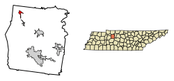
Location of Slayden in Dickson County, Tennessee.
|
|
| Country | United States |
| State | Tennessee |
| County | Dickson |
| Area | |
| • Total | 1.53 sq mi (3.97 km2) |
| • Land | 1.53 sq mi (3.97 km2) |
| • Water | 0.00 sq mi (0.00 km2) |
| Elevation | 735 ft (224 m) |
| Population
(2020)
|
|
| • Total | 170 |
| • Density | 110.89/sq mi (42.82/km2) |
| Time zone | UTC-6 (Central (CST)) |
| • Summer (DST) | UTC-5 (CDT) |
| ZIP code |
37165
|
| Area code(s) | 615 |
| FIPS code | 47-69080 |
| GNIS feature ID | 1303663 |
Slayden is a small town located in Dickson County, Tennessee, United States. In 2010, about 178 people lived there. By 2020, the population was 170.
Contents
Where is Slayden Located?
Slayden is in the northwestern part of Dickson County. You can find it at these coordinates: 36°17′39″N 87°28′14″W / 36.29417°N 87.47056°W. Tennessee State Route 235 goes through the town. This road leads northeast about 10 miles (16 km) to Cunningham. It also goes south about 18 miles (29 km) to Dickson. The United States Census Bureau says Slayden covers an area of about 1.53 square miles (3.97 square kilometers), and it's all land.
How Many People Live in Slayden?
| Historical population | |||
|---|---|---|---|
| Census | Pop. | %± | |
| 1920 | 158 | — | |
| 1930 | 162 | 2.5% | |
| 1940 | 164 | 1.2% | |
| 1950 | 90 | −45.1% | |
| 1960 | 101 | 12.2% | |
| 1970 | 95 | −5.9% | |
| 1980 | 69 | −27.4% | |
| 1990 | 111 | 60.9% | |
| 2000 | 185 | 66.7% | |
| 2010 | 178 | −3.8% | |
| 2020 | 170 | −4.5% | |
| Sources: | |||
In 2000, there were 185 people living in Slayden. These people lived in 79 households, and 54 of these were families. Most of the people were White. A small number were African American or Native American.
The population was spread out by age. About 19.5% of the people were under 18 years old. Around 17.8% were 65 years or older. The average age in Slayden was 43 years old.
A Look at Slayden's History
Slayden grew because of a railroad line. This line, called the "Mineral Branch," was built in the late 1800s. Its main purpose was to move iron from the nearby Cumberland Furnace to sell it. In the early 1900s, Slayden was an important community in Dickson County. It even had a department store.
However, things changed when the railroad line closed. The Cumberland Furnace also stopped working. This caused the area to face economic challenges. People started looking for jobs in bigger cities like Nashville and Clarksville. The local primary school in Slayden closed in 1960. Students then went to a larger school in Vanleer.
Changes in the 1980s and 2000s
By 1980, Slayden's population had dropped to just 69 people. For about ten years, it was known as Tennessee's smallest incorporated town. In the 1980s, the old railroad station was moved to Hickman County. It was meant to be part of an amusement park honoring Minnie Pearl, but the park was never built.
After the 2000 elections, the local voting area was closed. Voters were then split between Vanleer and Cumberland Furnace. In 2003, the town's future as an official community seemed uncertain. Only six people voted in a town election. Also, only two candidates ran for four unpaid positions on the town board. Luckily, the empty spots were filled by people who received write-in votes. More people voted in the 2005 elections, which helped the town continue.
The Slayden Family Connection
The name "Slayden" likely comes from the Slayden family. This family appeared in Dickson County records as early as 1820. Many members of this family were military officers, doctors, or dentists. The Slayden Cemetery, also called Guerin Cemetery, is where many family members are buried. The family name was still present in the area in the 1930s. Today, many relatives of this family use different spellings like "Slayton" or "Slaton."
See also
- In Spanish: Slayden (Tennessee) para niños
 | James B. Knighten |
 | Azellia White |
 | Willa Brown |

