Sleepy Hollow, Marin County, California facts for kids
Quick facts for kids
Sleepy Hollow
|
|
|---|---|
 |
|
| Country | |
| State | |
| County | Marin County |
| Area | |
| • Total | 2.966 sq mi (7.68 km2) |
| • Land | 2.966 sq mi (7.68 km2) |
| • Water | 0 sq mi (0 km2) 0% |
| Elevation | 177 ft (54 m) |
| Population
(2020)
|
|
| • Total | 2,401 |
| • Density | 809.51/sq mi (312.55/km2) |
| Time zone | UTC-8 (Pacific (PST)) |
| • Summer (DST) | UTC-7 (PDT) |
| ZIP Code |
94960
|
| Area codes | 415/628 |
| GNIS feature IDs | 1800792 2628818 |
| FIPS Code | 06-72184 |
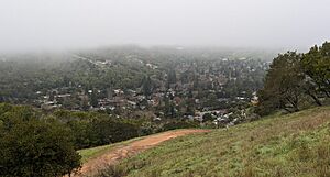
Sleepy Hollow is a small community in Marin County, California, United States. It's a special kind of place called a census-designated place, which means it's a community that is counted by the government but isn't officially a city or town. Sleepy Hollow is located about 7 miles south of Novato and sits at an elevation of 177 feet. In 2020, about 2,401 people lived there.
Contents
A Look Back: Sleepy Hollow's History
In 1838, a man named Domingo Sais received a large piece of land. This land grant was called Cañada de Herrera. It covered about 6,659 acres, which included what we now know as Sleepy Hollow, Fairfax, and parts of San Anselmo.
Early Farms and Roads
In the 1850s, Domingo Sais leased most of the Sleepy Hollow land to Harvey Butterfield. Butterfield started a dairy farm there. The long, winding 2-mile road that leads into and out of the community became known as "Butterfield's Road." This road is still the main way to get around Sleepy Hollow today.
Later, Peter Austin bought the land. He planted many poplar and eucalyptus trees that now line the road. However, Austin had to sell the land because of financial problems.
The Hotaling Family and a Famous Name
A rich family from San Francisco, the Hotalings, bought the land next. They built a fancy mansion at the end of the two-mile road. They named their new home "Sleepy Hollow." This name was a tribute to "The Legend of Sleepy Hollow," a famous short story written by their friend, author Washington Irving. The Hotalings loved to host big parties with many guests. Eventually, they moved back to San Francisco.
Dairy Farms and Big Plans
After the Hotalings, Sigmund Herzog owned the mansion and started another dairy farm on the property. Later, a group from Chicago bought the land. They had big plans to build a luxury hotel with a golf course, a pool, and a private lake. However, these plans didn't work out because of a major economic downturn before the Great Depression.
Golf, War, and a Fire
In the 1930s, Sleepy Hollow had a unique 18-hole golf course. It was the second largest of its kind in the country. In 1939, the land was given to the U.S. Army. They used it secretly to store ammunition during World War II.
After the war, in 1946, A.G. Raisch bought the mansion and 500 more acres. He also threw many grand parties. Eventually, he left the estate, and it was empty for several years. Sadly, the house caught fire and most of it burned down. Only a wall and some steps remain today.
Sleepy Hollow Becomes a Home
Sleepy Hollow became a place where people lived after Lang Realty opened shortly after World War II. In 1966, a Catholic group called the Dominican Order bought the land where the "Sleepy Hollow" mansion once stood. They opened the San Domenico School for Girls. Today, San Domenico School is a private school for both boys and girls from kindergarten through 12th grade. Girls can also board there in high school.
Exploring Sleepy Hollow's Geography
Sleepy Hollow is located in the eastern part of Marin County. To the south, it shares a border with the town of San Anselmo. The Terra Linda area of San Rafael is to the east. While there are no roads directly connecting Sleepy Hollow to Terra Linda, you can find hiking trails that do.
Main Roads and Connections
Butterfield Road is the main street in Sleepy Hollow. You can get to it from Sir Francis Drake Boulevard, which is a major road in Marin County that runs from east to west. The community uses ZIP code 94960 and area codes 415 and 628 for phone numbers.
North of Sleepy Hollow is Lucas Valley-Marinwood. However, there are no direct roads that connect these two communities.
The United States Census Bureau says that Sleepy Hollow covers an area of about 2.97 square miles, and all of it is land.
Who Lives in Sleepy Hollow: Demographics
In 2010, about 2,384 people lived in Sleepy Hollow. Most people live in family homes. About 97% of the people lived in households. The average household had about 2.78 people.
Many families in Sleepy Hollow have children under 18 living at home. The community is made up of people of different backgrounds. The median age in Sleepy Hollow was about 48.1 years old. Most of the homes in Sleepy Hollow are owned by the people who live in them.
Learning in Sleepy Hollow: Education
Sleepy Hollow is part of two school districts: the Ross Valley Elementary School District for younger students and the Tamalpais Union High School District for high school students.
See also
 In Spanish: Sleepy Hollow (California) para niños


