
San Anselmo, California facts for kids
Quick facts for kids
San Anselmo, California
|
|
|---|---|

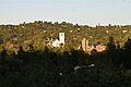
View of San Anselmo
|
|

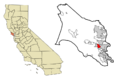
Location in Marin County and the state of California
|
|

San Anselmo, California
Location in the United States
|
|
| Country | United States |
| State | California |
| County | Marin |
| Incorporated | April 9, 1907 |
| Government | |
| • Type | Council–manager |
| Area | |
| • Total | 2.68 sq mi (6.93 km2) |
| • Land | 2.68 sq mi (6.93 km2) |
| • Water | 0.00 sq mi (0.00 km2) 0% |
| Elevation | 46 ft (14 m) |
| Population
(2020)
|
|
| • Total | 12,830 |
| • Density | 4,660.44/sq mi (1,799.41/km2) |
| Time zone | UTC−08:00 (Pacific) |
| • Summer (DST) | UTC−07:00 (PDT) |
| ZIP Codes |
94960, 94979
|
| Area codes | 415/628 |
| FIPS code | 06-64434 |
| GNIS feature IDs | 277591, 2413251 |
San Anselmo is a town in Marin County, California, United States. Its name comes from a Spanish phrase meaning "Saint Anselm."
The town is located about 1.5 miles (2.4 km) west of San Rafael. It sits at an elevation of 46 feet (14 m) and is about 20 miles (32 km) north of San Francisco. San Anselmo is surrounded by other towns: San Rafael to the east, Fairfax to the west, and Ross to the south. The beautiful Mount Tamalpais can be seen clearly to the south. In 2020, the town had a population of 12,830 people.
Contents
History of San Anselmo
San Anselmo has a rich history, from its early days as Native American land to becoming a modern town.
Early Beginnings of the Town
Before American and Spanish settlers arrived, the land where San Anselmo now stands was home to the Coast Miwok people. For many years, the area was mostly used for farming and raising animals.
Things began to change in 1874 when the North Pacific Coast Railroad (NPC) built a special track from San Anselmo to San Rafael. In 1875, the railroad completed a line that connected Sausalito to Tomales and then north to Cazadero, passing through San Anselmo.
For a short time, the town was even called "Junction" on railroad maps because of these connections. However, by 1883, the name San Anselmo was used again. The town got its own post office in 1892.
.jpg)
From 1902 until the early 1940s, San Anselmo was part of the Northwestern Pacific Railroad's electric train system. The "raised roadbed" you see today on Miracle Mile and Center Boulevard was once where the railroad tracks ran.
The railway eventually closed on March 1, 1941, because more people were using cars, and the Golden Gate Bridge made travel easier. The last of the main train station buildings in San Anselmo was taken down in 1963.
After the big 1906 San Francisco earthquake, San Anselmo's population grew. Many wealthy people from San Francisco, whose homes were damaged, moved to their summer houses in San Anselmo and made them their permanent homes.
In 1913, an electric train ride from San Anselmo to the Sausalito Ferry, and then across to the Ferry Building in San Francisco, took only 58 minutes. This included the 32-minute ferry trip.
San Anselmo officially became an incorporated town on April 9, 1907. Its name came from an old land grant, which called the valley "Canada del Anselmo," or "Valley of Anselm." Anselm was the name of a Native American person buried in the area. In the early 1900s, San Anselmo was even a center for making silent films!
San Anselmo During World War II
World War II brought some changes to San Anselmo.
Ammunition Storage in Sleepy Hollow
During the war, the Army set up a small ammunition storage area, called ASP #2, about 2 miles (3.2 km) from Sir Francis Drake Boulevard. This facility was located near San Anselmo Creek and had between 23 and 45 soldiers stationed there.
There were also two groups of anti-aircraft cannons, each with five soldiers working 24 hours a day. One group was on Stuyvesant Drive, and the other was on Oak Springs Hill.
The Sleepy Hollow Country Club, which was in the old Hotaling mansion, was still open during the war. Soldiers stationed at the ammo dump sometimes visited it for a break from their duties.
Air Raid Wardens on Patrol
During World War II, people called air raid wardens helped keep communities safe. For example, Zinnia and Alfred Heiden of San Francisco Boulevard would patrol their neighborhood at night during air raid drills. They would make sure no lights were shining from houses. People covered their windows with thick cloth or paper during the war to prevent enemy bombers from seeing lights at night.
Pilot Training Accidents
On November 2, 1941, just five weeks before the United States entered the war, two Curtiss P-40 warplanes flew very low over San Anselmo. They crashed into the east side of Bald Hill at 5:40 pm.
Lieutenants Thomas "Bud" L. Truax and Russell E. Speckman were killed in the crash. It was almost dark, misty, and there were low clouds. They were running low on fuel and had gotten separated from their training group. They were trying to find Hamilton Field to land. Truax Field in Madison, Wisconsin, was later named in memory of Lt. Truax.
A third pilot, Lt. Walter V. "Ramblin" Radovich, had left the group over San Rafael. He almost hit the city courthouse, clipped a tree, and then turned toward Hamilton Field. He was unsure of the land ahead and very low on fuel. He decided to climb above the clouds to 2,500 feet (760 m), set his plane to fly straight, and then parachute out. He broke his left leg when he left the plane and landed near Highway 101. Surprisingly, after Lt. Radovich bailed out, his airplane slowly came down through the clouds and landed relatively smoothly without its landing gear.
San Anselmo After World War II
On March 12, 1974, San Anselmo officially became a town. In 1963, a cast iron statue of a deer was given to the town by Joeseph Dondero. Locals lovingly call this statue "Sugarfoot." It still stands today, and children enjoy riding on its back after visiting the library nearby.
The town is even mentioned in a song called "Snow in San Anselmo" by singer-songwriter Van Morrison. This song is about an unusual snowstorm that happened when he lived near San Anselmo in the 1970s.
One of San Anselmo's most famous residents was movie director George Lucas. He used some of the money from his film American Graffiti to buy an old Victorian house in San Anselmo. His wife at the time, Marcia Lucas, named it "Parkhouse." Lucas spent two and a half years writing much of the Star Wars script in a room at the back of his San Anselmo house. In 1977, he showed an early version of Star Wars to a small group of Hollywood friends at his San Anselmo home.
Geography and Climate
San Anselmo has a mild climate and is located in a unique natural area.
Weather in San Anselmo
The average high temperature in San Anselmo is 85 °F (29 °C) in July. The average low temperature is 41 °F (5 °C) in January and December. The hottest temperature ever recorded was 111 °F (44 °C) in July 1972. The coldest was 18 °F (−8 °C) in December 1990. On average, the town gets about 47.47 inches (1,206 mm) of rain each year, with January being the rainiest month.
Waterways and Hills
Almost all of San Anselmo is located within the 28-square-mile (73 km2) Ross Valley Watershed, which drains into San Francisco Bay. The main waterway in the town is San Anselmo Creek, which is a branch of Corte Madera Creek. Other creeks like Sleepy Hollow Creek, Sorich Creek, East Fork Creek, and West Fork Creek also flow through the town.
The town's natural landscape is shaped by the hills of Ross Valley. To the north are Red Hill and Grove Hill. Bald Hill is to the southwest, and Moore Hill is to the east. In the distance to the south, you can see Mount Tamalpais.
Roads and Transportation
There are three main roads that run through San Anselmo. They meet at a spot locally known as "the Hub," which is near the town's main business area. Sir Francis Drake Boulevard comes from Ross, turns northwest at the Hub, and then goes west to Fairfax. Red Hill Avenue (also called "The Miracle Mile") comes from San Rafael and turns into Center Boulevard at the Hub. Center Boulevard then goes northwest to Fairfax, with Sir Francis Drake running parallel to it.
Flooding in San Anselmo
A large part of southern and western San Anselmo is built on a natural floodplain. This means that about every 15–23 years, heavy rains can cause San Anselmo Creek to flood the center of town by up to 4 feet. Major floods happened in 1925, 1940, 1963, January 1982, and December 2005. The worst flood, on January 2, 1982, had the highest creek water level.
The historic raised railroad bed, which is now Center Boulevard, acts like a barrier. It helps protect some of the houses on the west side of town from floods. Many homes in the floodplain, known as the "Flatlands," have been built with raised foundations since at least 1920 to handle these smaller, regular floods.
Many of San Anselmo's well-known antique shops, boutiques, and restaurants are located along the banks of San Anselmo Creek.
Population and People
San Anselmo is home to a diverse community.
Population Changes Over Time
| Historical population | |||
|---|---|---|---|
| Census | Pop. | %± | |
| 1910 | 1,531 | — | |
| 1920 | 2,475 | 61.7% | |
| 1930 | 4,650 | 87.9% | |
| 1940 | 5,790 | 24.5% | |
| 1950 | 9,188 | 58.7% | |
| 1960 | 11,584 | 26.1% | |
| 1970 | 13,031 | 12.5% | |
| 1980 | 12,067 | −7.4% | |
| 1990 | 11,743 | −2.7% | |
| 2000 | 12,378 | 5.4% | |
| 2010 | 12,336 | −0.3% | |
| 2020 | 12,830 | 4.0% | |
| U.S. Decennial Census | |||
The population of San Anselmo has grown steadily over the years. In 1910, there were 1,531 people, and by 2020, the population had reached 12,830.
Who Lives in San Anselmo? (2010 Census)
According to the 2010 census, San Anselmo had 12,336 people. Most residents, about 90.3%, were White. About 3.5% were Asian, and 0.9% were African American. People of Hispanic or Latino background made up 5.8% of the population.
Almost everyone (99.6%) lived in households, meaning they lived in homes with families or roommates. There were 5,243 households in total. About 32.3% of these households had children under 18 living in them. The average household had 2.34 people.
The median age in San Anselmo was 44.9 years old. This means half the people were older than 44.9, and half were younger. About 23.3% of the population was under 18 years old.
Most homes (66.5%) were owned by the people living in them, while 33.5% were rented.
Famous People from San Anselmo
Many interesting people have connections to San Anselmo.
- Dave Anthony (born 1967), a comedian, actor, and podcaster.
- Arj Barker (born 1974), a stand-up comedian who went to Sir Francis Drake High School.
- John Boccabella (born 1941), a former Major League Baseball player.
- Terry Bozzio (born 1950), a drummer who played with Frank Zappa and started the band Missing Persons.
- Gary Fisher (born 1950), known for inventing the mountain bike. He opened his first bike shop in San Anselmo.
- Dana Gilbert (born 1959), a tennis player.
- Jane Levy (born 1989), an actress who grew up in San Anselmo.
- George Lucas (born 1944), the famous film director, screenwriter, and producer.
- Don Novello (born 1943), a comedian.
- Joe Ryan (born 1996), a Major League Baseball player for the Minnesota Twins.
- Mary Ann Shaffer (1934–2008), a writer who lived and passed away in San Anselmo.
- Ali Akbar Khan, a famous sarod player and composer.
- Zakir Hussain, a master tabla player.
- Neal Schon, the guitarist for the rock band Journey.
- Michael Schwab (born 1952), a graphic designer and illustrator whose studio is in San Anselmo.
- Scott Thunes (born 1960), a bass guitarist who played with Frank Zappa and other bands. He grew up in San Anselmo.
Schools in San Anselmo
San Anselmo has several schools for students of all ages. The town is part of the Ross Valley Elementary School District and the Tamalpais Union High School District.
Here are some of the schools in San Anselmo:
- Brookside Elementary School: Grades K-5
- Hidden Valley Elementary School: Grades K-5
- Wade Thomas Elementary School: Grades K-5
- White Hill Middle School: Grades 6-8
- Saint Anselm's Catholic School: A private school founded in 1924, for grades K-8.
- San Domenico School: A co-ed school for pre-kindergarten through 12th grade.
- Archie Williams High School: Grades 9-12
- San Francisco Theological Seminary: A seminary that is part of the Presbyterian Church (USA) system.
- Stapleton School of the Performing Arts
Images for kids
-
View of San Anselmo
-
Location in Marin County and the state of California
See also
 In Spanish: San Anselmo (California) para niños
