Slippery Rock Brook facts for kids
Quick facts for kids Slippery Rock Brook |
|
|---|---|

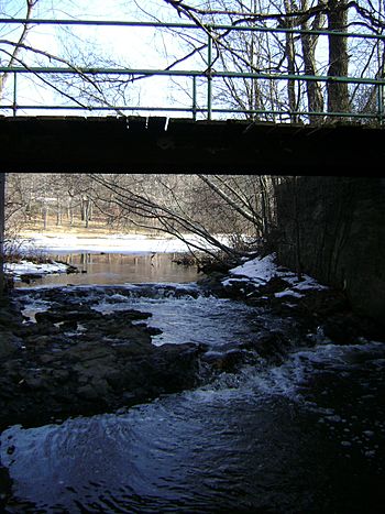
Slippery Rock Brook viewed from under Mountain Ave in Woodland Park
|
|

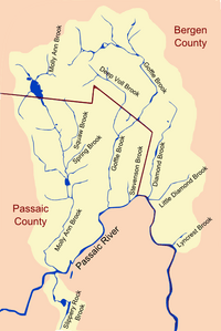
Major Tributaries of the North Bend of the Passaic River
|
|
| Country | United States |
| State | New Jersey |
| County | Passaic |
| Physical characteristics | |
| Main source | Woodland Park, Passaic County, New Jersey, United States 379 ft (116 m) 40°53′23.34″N 74°11′14.39″W / 40.8898167°N 74.1873306°W |
| River mouth | Passaic River Paterson, Passaic County, New Jersey, United States 118 ft (36 m) 40°54′42.8″N 74°11′22.62″W / 40.911889°N 74.1896167°W |
| Length | 2 mi (3.2 km) |
Slippery Rock Brook is a small stream in New Jersey, United States. It flows into the Passaic River. This brook is located in Passaic County. It helps drain water from the western side of First Watchung Mountain. The brook passes through the city of Paterson and the town of Woodland Park.
Journey of Slippery Rock Brook
Slippery Rock Brook starts in Woodland Park. Its source is south of Weasel Drift Road, inside Rifle Camp Park. From there, it flows north into Garret Mountain Reservation.
As it travels, the brook forms a long, natural lake called Barbour Pond. This pond is about 0.3-mile (0.48 km) long and 0.05-mile (0.080 km) wide. After Barbour Pond, the brook turns west for a short distance.
It then helps create two man-made ponds: the New Street Reservoir and Highland Lake. At Highland Lake, the brook turns north again. It flows under Interstate 80 as it enters the city of Paterson.
The last half mile of the brook flows through an urban area. It winds its way to the Passaic River, ending in Pennington Park. The brook's mouth is very close to where another stream, Molly Ann Brook, joins the Passaic River. Slippery Rock Brook joins the Passaic about 300 feet (91 m) upstream from Molly Ann Brook.
Nature Along the Brook
Most of the area right next to Slippery Rock Brook has been developed by cities. However, a big part of the natural area, called the riparian corridor, is still untouched. This untouched section is found within Garret Mountain Reservation.
South of Barbour Pond, the brook flows through a shaded valley. Here, you can find tall yellow birch trees and witch-hazel plants. These trees and shrubs provide shade and a home for wildlife.
Along the banks of the brook, you might also spot beautiful plants like rhododendrons. In May, during the flowering season, you can see bright trout lily flowers. These plants add vibrant colors to the natural environment around the brook.
 | Precious Adams |
 | Lauren Anderson |
 | Janet Collins |

