Molly Ann Brook facts for kids
Quick facts for kids Molly Ann Brook |
|
|---|---|

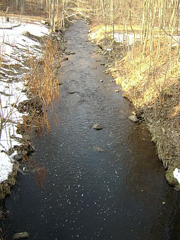
Molly Ann Brook viewed from Squaw Brook Road in North Haledon
|
|

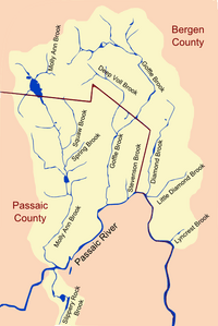
Major Tributaries of the North Bend of the Passaic River
|
|
| Other name(s) | Molly Ann’s Brook |
| Country | United States |
| State | New Jersey |
| Counties | Passaic, Bergen |
| Physical characteristics | |
| Main source | Franklin Lakes, Bergen County, New Jersey, United States 495 ft (151 m) 40°59′34.37″N 74°11′34.15″W / 40.9928806°N 74.1928194°W |
| River mouth | Passaic River Paterson, Passaic County, New Jersey, United States 117 ft (36 m) 40°54′47.26″N 74°11′18.60″W / 40.9131278°N 74.1885000°W |
| Length | 6.75 mi (10.86 km) |
| Basin features | |
| Tributaries |
|
Molly Ann Brook, sometimes called Molly Ann's Brook, is a small river in New Jersey. It flows south between two mountain ranges, First Watchung Mountain and Second Watchung Mountain. This brook travels through Passaic County and Bergen County. It eventually joins the Passaic River. Along its journey, Molly Ann Brook passes through several towns. These include Paterson, Haledon, Prospect Park, North Haledon, and Franklin Lakes.
Contents
A Journey Through Time: History of Molly Ann Brook
Molly Ann Brook has a rich history. Like other nearby rivers, it played a part in the American Revolutionary War. In 1780, it was known as Krakeel Val. The brook flowed near where General Lafayette's troops were stationed. General St. Clair's soldiers camped by the brook in October and November of that year.
How Molly Ann Brook Got Its Name
In the late 1700s, a pioneer family lived near the brook's mouth in Paterson. This was the family of Dirck and Molly Van Houten. Their ninth child, Adreyean, was known as Molly’s Yawn. This Dutch name meant Molly’s son. Since he lived at his parents' home, the brook running through their land became known as Molly Yawn’s Brook. Over time, this name changed to what we know today: Molly Ann’s Brook.
Dealing with Floods
In the early 1900s, Molly Ann Brook was known for its big floods. A very large flood happened in July 1945, affecting four towns. To help prevent future floods, people suggested building overflow tunnels in the late 1950s.
Later, in 1999, the United States Army Corps of Engineers finished a big project. They worked on the lower parts of the brook to control flooding. This project made the brook much deeper and wider. They built channels using concrete and rocks. This helps protect the area from heavy storms.
Where Molly Ann Brook Flows
Molly Ann Brook starts in Franklin Lakes. Its source is south of Franklin Avenue. This is about 2,000 feet west of Goffle Pond. Goffle Pond is where the nearby Goffle Brook begins.
From Golf Course to Reservoirs
After starting, Molly Ann Brook flows through the High Mountain Golf Club. Then, it meets two smaller streams. These streams combine to form Haledon Reservoir. This is a large artificial lake. Below Haledon Reservoir is another man-made lake called Lower Basin Pond. Further downstream, there is also a swimming hole.
Meeting Other Streams
In North Haledon, Molly Ann Brook is joined by its biggest helper, Squaw Brook. Squaw Brook flows north from this meeting point into the town of Wyckoff. About three-quarters of a mile downstream, a tiny stream called Spring Brook joins Molly Ann Brook. This happens just south of Overlook Avenue.
Another small stream then merges with the brook. This stream runs next to Ballentine Drive. It drains part of the western side of First Watchung Mountain in North Haledon. After this, Molly Ann Brook reaches Oldham Pond.
At Oldham Pond, Molly Ann Brook gets another important helper. This is a steep stream that drains the southwestern sides of Mount Cecchino and High Mountain. These are the highest peaks of Second Watchung Mountain.
Through Towns to the Passaic River
Beyond Oldham Pond, one more stream joins Molly Ann Brook. This stream flows east from Second Watchung Mountain. It joins just south of the Haledon-North Haledon border. Here, the brook changes from a suburban setting to an urban one. It flows through Prospect Park, Haledon, and Paterson.
In these urban areas, the brook looks very artificial. It is lined with concrete walls to control floods. Finally, Molly Ann Brook joins the Passaic River in Paterson. This meeting point is about 3,000 feet west of the Great Falls. Molly Ann Brook is the last stream to join the Passaic River before its waters plunge over the impressive Great Falls.
 | Madam C. J. Walker |
 | Janet Emerson Bashen |
 | Annie Turnbo Malone |
 | Maggie L. Walker |

